 2017, Vol. 35
Institute of Oceanology, Chinese Academy of Sciences
Article Information
- WU Lingjuan(吴玲娟), WU Xiaofen(吴晓芬), BAI Tao(白涛)
- Comprehensive analysis of the origin of giant jellyfish near Qinhuangdao in summer
- Chinese Journal of Oceanology and Limnology, 35(5): 1061-1069
- http://dx.doi.org/10.1007/s00343-017-6083-8
Article History
- Received Mar. 31, 2016
- accepted in principle Jun. 16, 2016
- accepted for publication Jul. 27, 2016


2 State Key Laboratory of Satellite Ocean Environment Dynamics, Hangzhou 310012, China
The impacts of global warming and human disturbance appear to be causing an increase in the frequency of giant jellyfish blooms in recent decades (Brodeur et al., 1999; Mills, 2001; Nagai, 2003). For example, the numbers of jellyfish in populations off Hebei Province have increased yearly since 2008 (Zheng et al., 2014), thereby negatively affecting the fishery resources and the safety of beach-goers. Informal statistics indicate that during one giant jellyfish bloom near Qinhuangdao in 2013 (Fig. 1), more than 1 000 beach-goers were stung and at least one child was stung to death by Nemopilema nomurai (Zheng et al., 2014). This event raised serious concern among the public and local government.

|
| Figure 1 Giant jellyfish in an aggregation near Qianshui Bay, Qinhuangdao in August 2013 |
Dominant species of jellyfish known to occur in the Bohai Sea near Qinhuangdao are Rhopilema esculentum, N. nomurai and Aurelia aurita. According to observation of local fishermen, every year, no medusa or larvae of N. nomurai or R. esculentum were observed there during the previous winter and spring, yet mature jellyfish (bell diameter 60–100 cm) can be found in summer in the area (Zheng et al., 2014). Hence, the occurrence of adult N. nomurai and R. esculentum off Qinhuangdao in summer would indicate that they belong to a remote rather than local population. The goal of this study was to determine the possible origin of giant jellyfish aggregations in the area, thus providing information to facilitate the long-term control and prevention of dramatic seasonal increases of jellyfish.
To determine the possible origin of the giant jellyfish off Qinhuangdao, we developed a backward tracking model based on the Lagrangian particle method, which is widely applied to the study of oil spills, green tides and jellyfish blooms (Johnson et al., 2001; Wu et al., 2011, 2015; Gao et al., 2014). Similar research has investigated jellyfish aggregations in the Sea of Japan and the Yellow Sea. Moon et al. (2010) simulated the distribution of N. nomurai in the Yellow Sea and East China Sea using a hydrodynamic version of the Regional Ocean Modeling System (ROMS) that excluded tidal processes. Their results showed approximately 70% of N. nomurai released near the Changjiang (Yangtze) River estuary during spring entered the Sea of Japan in autumn. Luo et al. (2012) arrived at an opposite conclusion using a model that included tides. Zhang et al. (2012) similarly traced the possible origin of jellyfish aggregations off Qingdao, without considering the animal's autonomic (vertical) movement, and concluded that sources may include the waters of Hangzhou Bay, on the Jiangsu coast, and areas adjacent to the Changjiang River estuary.
2 MODEL SETUP 2.1 Model configurationROMS is a three-dimensional, free-surface, terrain-following, numerical ocean model with diverse applications that is widely used by the oceanographic research community (Penven et al., 2001; Fennel et al., 2006). ROMS solves the Reynolds-averaged Navier-Stokes equations using hydrostatic and Boussinesq approximations. Consistent with the location of the giant jellyfish event off Qinhuangdao, three dynamic sub-region models were established according to the multinested technique (Fig. 2a). We applied large-, median and small-domain models to cover the northwestern Pacific Ocean, the East China Sea, and the Bohai Sea, respectively, allowing increasing resolution. The small-domain model had a horizontal grid resolution of 1/120° and six vertical layers. The model topography was derived from the General Bathymetric Chart of the Oceans (GEBCO), with a horizontal resolution of 1′, and corrected using the shoreline contours and depth depicted in Google Earth and a nautical chart. Meteorological forcing used QuikSCAT and ASCAT data for monthly mean wind, salinity and heat fluxes calculated with the Haney equation (Barnier, 1998). The initial and boundary conditions for the large-domain model, including elevation, water current, temperature and salinity, were obtained from Simple Ocean Data Assimilation (SODA, 1990–2010). Tidal effects were included in the small-domain model by adding the tidal elevation to the sea-level height at the open boundaries.

|
| Figure 2 Nested domain of the model (big and small boxes represent the domain of the East China Sea [median domain] and the Bohai Sea [small domain], respectively) and the initial positions of the released particles and the topography of the tracked area |
Without considering its autonomic (vertical) movement, jellyfish may be regarded as passive particles transported by ocean currents. The Lagrangian particle method is used to simulate the movement of particles by random walk mode (Zhang, 2005). Convective and diffusive motions are transformed into the Fokker-Planck equation, and then the displacement of each particle (or simulated trajectory) is determined by solving Lagrange's equation. Backward tracking using the Lagrangian particle method calculates the position of particles by inverse integration in time. Accordingly, we chose this method to trace the likely origins of the giant jellyfish near Qinhuangdao.
2.3 Numerical simulationsKawahara et al. (2006) showed that 13℃ is a critical temperature for the strobilation of N. nomurai and R. esculentum jellyfish, and the waters of the Bohai Sea are known to reach this temperature in May. We designed two numerical experiments to simulate the trajectory of particles released at different water layers and dates, and then traced them backward to May 1. For the first simulation, we released 165 particles at the sea surface near Qinhuangdao on August 15, August 1, July 15 and July 1. For the second simulation, we released particles on August 15 from the surface, middle and bottom water layers.
3 EXAMINATION OF OCEAN CIRCULATION IN THE BOHAI SEATo accurately simulate the spatiotemporal distribution of jellyfish trajectories, we first needed to validate the ocean circulation in the Bohai Sea by applying observational data. Ocean current velocity was filtered by a 24-hour average to remove the tidal signal. Figures 3 and 4 show the values for the residual current velocity. We found that the residual current velocity was relatively low throughout the summer (May–August). One obvious stream flows along the south coast of the Bohai Sea from east to west with a width of ~50km and speed of ~10 cm/s. This stream turns northwards near the western coast of Bohai Bay, and then divides near the Luanhe River estuary. From there, one stream continues northward along the coast of Caofeidian Port, Qinhuangdao, and onward to Liaodong Bay, and the other steam runs through the center of the Bohai Sea and to the middle of Liaodong Bay. In addition, a weak anticyclonic eddy occurs between the two streams. The spatial structure of the residual current was similar from May to August (Fig. 3), although the magnitude was smallest in May, strongest in July, and weak again in August. Taking data for July as an example (Fig. 4), the major direction of the residual current at the surface was northward in Laizhou Bay; by contrast, in the middle water layer, the major direction was southward in the most part of the bay. Furthermore, there is one clockwise gyre in the southwestern part of the bay, and the gyre structure appears similar even in the bottom water layer. In Bohai Bay, there is a strong coastal current in the southern part and a clockwise current from the surface to the bottom in the northern part. In Liaodong Bay, there is an obvious anticyclonic gyre in the surface layer that disappears in the middle water layer and one southwestern compensation current in the bottom water layer. These reported features are consistent with the findings of previous studies (Huang et al., 1998; Zhao and Cao, 1998).

|
| Figure 3 Residual surface current in the Bohai Sea, from May to August |

|
| Figure 4 Monthly mean residual current in the surface (a), middle (b) and bottom (c) water layers of the Bohai Sea in July |
Based on the above-mentioned model-generated velocity fields, we simulated trajectories for the particle paths in the Bohai Sea. Particles released at different dates in summer mostly moved southwestward, and none of the particles were detected beyond 40.1°N (Fig. 5). The simulation shows particles released on August 15 moving southwestward along the isobath, influenced by the current, aggregating near Luanhe River estuary, with some reaching Jingtang Port. From Jingtang Port, some particles moved southwestward to the center of Bohai Bay and reached waters between Feiyan Shoal and new Huanghe (Yellow) River estuary, where they moved toward the shore. Other particles that reached Jingtang Port moved northeastward as a part of an anticyclonic gyre near eastern part of Jingtang Port, which widened their trajectories.

|
| Figure 5 The trajectories of particles released on August 15 (a), August 1 (b), July 15 (c) and July 1 (d), traced backward to May 1 |
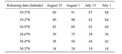
As of May 1, 38% of particles passed through the 38.4°N and 18% for 38.2°N (Table 1). The particles' trajectory from Feiyan Shoal to the new Huanghe River estuary was relatively lengthy owing to the coastal current's high velocity from mid-to late June. The paths of particles released on August 1, July 15 and July 1 were more or less consistent with the path of particles released on August 15. Particles released on August 1 moved closer to the shore between Qinhuangdao and Caofeidian Port and reached Jingtang Port. Fewer (more) particles moved northeastward (southwestward) because abovementioned anticyclonic gyre became weaker. Therefore, more particles released at the surface passed through the 38.6°N, 38.4°N and 38.2°N than other cases (Table 1). From May to early June, particles reached the Zhuangxi tide station, and their predicted path was shorter owing to the weaker coastal current. Some particles released on August 15 and August 1 reached waters between Feiyan Shoal and new Huanghe River estuary, whereas particles released on July 15 and June 1 only reached waters between Feiyan Shoal and the Zhuangxi tide station.
 |
No particles released from the middle and bottom water layers reached waters between the Zhuangxi tide station and the new Huanghe River estuary (Fig. 6), but instead moved either southwestward along the isobath and were retained in the middle layer near Caofeidian Port or moved northeastward to the center of Liaodong Bay and were retained in the bottom water layer.

|
| Figure 6 The trajectories of particles released from the middle (a) and bottom (b) water layers |
Figure 7 depicts backward-tracking distribution scenarios for particles released at the sea surface on August 15. From August 15 to August 1 (Fig. 7a), particles would move mostly southwestward along the 10–20 m isobath from Qinhuangdao to the Luanhe River. From August 1 to July 15 (Fig. 7b), the particle paths would narrow, parallel to the isobath, and reach as far as 39.1°N. From July 15 to July 1, the particles would aggregate in waters south of the Luanhe River (Fig. 7c), and ~89% of the particles crossed the 39.2°N (Table 1). From there, most of those particles would move westward and enter Bohai Bay (Fig. 7d). On June 15, the particles would move continuously westward to the center of Bohai Bay and scatter parallel to the shoreline (Fig. 7e). On May 15, the particles would distribute in the shape of an inverted spoon parallel to the bay's coastline owing to the influence of cyclonic circulation in the southeastern part of Bohai Bay (Fig. 7f); some particles would arrive at the north of the Zhuangxi tide station and the Huanghe River harbor, and 32% of the particles would cross the 38.4°N latitude. From May 15 to May 1 (Fig. 7g), the northern portion of particles would move northward and the southern portion would move continuously southward, and then reach waters near the Zhuangxi tide station. Particles that reach the vicinity of Zhuangxi tide station or Huanghe River harbor would then move along the shoreline, influenced by the strong coastal current between Feiyan Shoal and the new Huanghe River estuary (Fig. 3a–b).

|
| Figure 7 Backward tracking of the particles released on August 15, showing their distributions at the sea surface on August 1 (a), July 15 (b), July 1 (c), June 15 (d), June 1 (e), May 15 (f), and May 1 (g) |
In estimating potential source regions for the giant jellyfish observed off Qinhuangdao in summer, the Lagrangian tracking model provided consistent results. The transport scenarios for particles released on different dates and in different water layers show the particles moving mainly southwestward, and none moving beyond 40.1°N. This general pattern indicates that giant jellyfish observed off Qinhuangdao could not have originated in the more northerly Liaodong Bay. Backward tracking of the particles released on August 15 and 1 show that they move southwestward along the isobath, aggregate near the Luanhe River estuary, and then reach waters near Jingtang Port. Near Jingtang Port, some particles would move southwestward to the central Bohai Bay, arriving in waters between Feiyan Shoal and the new Huanghe River estuary and then moving shoreward. However, other particles near Jingtang Port would move northeastward because of an anticyclonic gyre near the eastern waters of Jingtang Port. The simulated drifting paths were wider for particles released on August 15 than those released on August 1 because of this stronger anticyclonic gyre. The drifting paths were narrower for particles released on July 15 and June 1 because of the disappearance of abovementioned cyclonic gyre. The anticyclonic circulation in the eastern part of Bohai Bay near 38.4°N influenced all particles there, distributing them in the shape of an inverted spoon along the coastline.
Simulations for particles released at the sea surface on August 15 and 1 show them reaching the center of the Bohai Sea as well as waters between Feiyan Shoal and the new Huanghe River estuary. Scenarios for particles released on July 15 and 1 show them similarly reaching the center of the Bohai Sea and waters between Feiyan Shoal and then only as far as the Zhuangxi tide station. Thus, the Lagrangian particle method allowed us to predict that waters of the central Bohai Sea and the area between Feiyan shoal and the new Huanghe River estuary could be the origin of the giant jellyfish aggregations observed off Qinhuangdao in summer.
According to the experimental results, particles released in the middle and bottom water layers moved southwestward along the isobath and were eventually retained near Caofeidian port in the middle layer. In contrast, particles that moved northeastward to the center of Liaodong Bay were retained in the bottom water layer. These additional experimental results indicate that waters near Caofeidian Port and in the middle Liaodong Bay may also be a source of the jellyfish.
Qin et al. (1985) examined sediment distribution in the Bohai Sea during the early 1980s. They reported that fine-grained sediment from the Huanghe River is distributed mainly in the southern part of Bohai Bay and the western part of Laizhou Bay, as well as along a narrow strip between the old to new Huanghe River estuary and Qinhuangdao; conversely, coarse grains are distributed mainly on either side of the strip. A study by Qiao et al. (2010) used data collected in 2007 to reveal the distribution of grain-size and the transport patterns of seafloor sediments in the Bohai Sea. Those authors reported a prevalence of sandy-mud sediment between Feiyan Shoal and the new Huanghe River estuary (parallel to the shoreline of the Huanghe River delta); this describes a benthic environment conducive to the attachment and growth of jellyfish polyps. In contrast, a prevalence of silty-sand and muddy-sand sediments in the shoal at Liaodong Bay and at the center of the Bohai Sea are not favorable environments for jellyfish polyps. Although the Huanghe River estuary has been diverted from 1980 to 2007, the benthic environment between Feiyan Shoal and the new Huanghe River estuary is conducive to the attachment and growth of jellyfish polyps, while the benthic environment between middle of Liaodong Bay and Caofeidian is not. The simulated paths of particles traced backward from the middle and bottom water layers likewise show that these waters could not be the origin of giant jellyfish. As demonstrated by Qiao et al. (2010), the benthic environment of the central Bohai Sea is not conducive to the attachment and growth of polyps, which further supports the conclusion that the central portion of Bohai Sea is an unlikely origin of the jellyfish.
Observational data (Zheng et al., 2014).indicate that the species of giant jellyfish found in the southeastern portion of Bohai Bay and in the Huanghe River estuary match the jellyfish species found off Qinhuangdao in summer. Moreover, the number of jellyfish gradually decreases moving northward from Bohai Bay to waters off Qinhuangdao Hence, the available observational data also support our conclusions that giant jellyfish found near Qinhuangdao in summer probably originate in waters between Feiyan Shoal and the new Huanghe River estuary.
A giant jellyfish bloom observed near Qingdao in the Yellow Sea was shown to originate mainly from the Changjiang River estuary (Zhang et al., 2012). Pending the findings of further field studies, we suspect that waters near river estuaries with fine-grained sediments and rich nutrients are most conducive to the attachment and growth of giant jellyfish polyps.
6 CONCLUSIONIn recent years, jellyfish blooms in coastal waters of the Bohai Sea off Qinhuangdao have included the dominant species N. nomurai, R. esculentum and Aurelia aurita. The cnidoblasts of N. nomurai are toxic, and, in 2013, beach visitors were frequently stung, which led to strong concerns among the public and in local government. The larvae of N. nomurai and R. esculentum were not found in the area during the previous winter and spring, however. Therefore, we developed a backward particle-tracking model to simulate the possible trajectories of jellyfish medusa in the Bohai Sea and conducted a series of numerical simulations to identify the possible origin of the giant jellyfish observed near Qinhuangdao. The experimental results show that passive particles (representing jellyfish) released at the surface layer at different dates in summer had consistent trajectories. Particles released at the sea surface on August 1 and 15 could be traced back to the center of the Bohai Sea and to waters between Feiyan Shoal and the new Huanghe River estuary (parallel to the Huanghe River delta). Particles released on July 1 and 15 were similarly traced back to the center of the Bohai Sea and to waters between Feiyan Shoal and then only to the Zhuangxi tide station. Particles released in the middle and bottom water layers could be traced back only to the middle of the more northerly Liaodong Bay. Sand deposition in the Liaodong Bay, central part of Bohai Sea and near Caofeidian Port, creates a benthic environment that is not conducive to the attachment and growth of jellyfish polyps. Considering the numerical simulation results, the distribution characteristics of the sediment, and observational data for giant jellyfish in the Bohai Sea, we propose that giant jellyfish observed off Qinhuangdao in summer originated in waters between Feiyan shoal and the new Huanghe River estuary.
7 ACKNOWLEDGEMENTWe thank the Hebei Bohai Ocean & Fisheries Science Research Institute for providing observational data on giant jellyfish. We greatly appreciate the insightful comments provided by the editor and two anonymous reviewers and thank for useful suggestion from Dr. LI Rui and Dr. XU Jiangling.
| Barnier B. 1998. Forcing the ocean. In: Chassignet E P, Verron J eds. Ocean Modeling and Parameterization. Kluwer Academic, The Netherlands. p. 45-80. |
| Brodeur R D, Mills C E, Overland J E, Walters G E, Schumacher J D, 1999. Evidence for a substantial increase in gelatinous zooplankton in the Bering Sea, with possible links to climate change. Fisheries Oceanography, 8(4): 296–306. Doi: 10.1046/j.1365-2419.1999.00115.x |
| Fennel K, Wilkin J, Levin J, Moisan J, O'Reilly J, Haidvogel D. 2006. Nitrogen cycling in the Middle Atlantic Bight: results from a three-dimensional model and implications for the North Atlantic nitrogen budget. Global Biogeochemical Cycles, 20(3): GB3007, http://dx.doi.org/10.1029/2005GB002456. |
| Gao S, Huang J, Bai T, Cao Y J, Xu J L, 2014. Study on the ensemble forecast of oil spilled sources. Marine Sciences, 38(3): 42–45. |
| Huang D J, Su J L, Zhang L R, 1998. Numerical study of the winter and summer circulation in in the Bohai sea. Acta Aerodynamica Sinica, 16(1): 115–121. |
| Johnson D R, Perry H M, Burke W D, 2001. Developing jellyfish strategy hypotheses using circulation models. Hydrobiologia, 451(1): 213–221. |
| Kawahara M, Uye S I, Ohtsu K, Iizumi H, 2006. Unusual population explosion of the giant jellyfish Nemopilema nomurai (Scyphozoa:Rhizostomeae) in East Asian waters. Marine Ecology Progress Series, 307: 161–173. Doi: 10.3354/meps307161 |
| Luo X F, Wei H, Wang Y H, 2012. Processes influencing jellyfish particle tracking in the yellow sea and East China Sea. Oceanologia et Limnologia Sinica, 43(3): 635–642. |
| Mills C E, 2001. Jellyfish blooms:are populations increasing globally in response to changing ocean conditions?. Hydrobiologia, 451(1-3): 55–68. |
| Moon J H, Pang I C, Yang J Y, Yoon W D, 2010. Behavior of the giant jellyfish Nemopilema nomurai in the East China Sea and East/Japan Sea during the summer of 2005:a numerical model approach using a particle-tracking experiment. Journal of Marine Systems, 80(1-2): 101–114. Doi: 10.1016/j.jmarsys.2009.10.015 |
| Nagai T, 2003. Recovery of fish stocks in the Seto Inland Sea. Marine Polluttion Bulletin, 47(1-6): 126–131. Doi: 10.1016/S0025-326X(03)00100-0 |
| Penven P, Lutjeharms J R E, Marchesiello P, Roy C, Weeks S J, 2001. Generation of cyclonic eddies by the Agulhas Current in the lee of the Agulhas Bank. Geophysical Research Letters, 28(6): 1 055–1 058. Doi: 10.1029/2000GL011760 |
| Qiao S Q, Shi X F, Wang G Q, Yang G, Hu N J, Liu S F, Liu Y G, Zhu A M, Li C X, 2010. Discussion on grain-size characteristics of seafloor sediment and transport pattern in the Bohai Sea. Acta Oceanologica Sinica, 32(4): 139–147. |
| Qin Y S, Zhao Y Y, Zhao S L. 1985. Geology in Bohai Sea. Science Press, Beijing, China. p. 1-232. |
| Wu L J, Cao C H, Huang J, Cao Y J, Gao S, Bai T, 2011. Numerical tracing simulation on green tides in the Yellow Sea for contingency forecast. Marine Sciences, 35(6): 44–47. |
| Wu L J, Gao S, Liu G Y, Bai T, 2015. Study on the ensemble forecast of large jellyfish drift in the coastal waters of Qingdao. Marine Forecasts, 32(2): 62–71. |
| Zhang H Y, Zhao L, Wei H, 2012. Origin of the giant jellyfish in Qingdao offshore in summer. Oceanologia et Limnologia Sinica, 43(3): 662–668. |
| Zhang X Y. 1996. Ocean Outfall Modeling-Interfacing Near and Far Field Models with Particle Tracking Method. United States: Massachusetts Institute of Technology. Ph. D. thesis. p. 1-126. |
| Zhao B R, Cao D M, 1998. Dynamic analysis and numerical modeling of forming mechanisms of winter circulations in the Bohai Sea. Oceanologia et Limnologia Sinica, 29(1): 86–96. |
| Zheng X R, Li Y, Rao Q H, Mu J D, 2014. Analysis of the reasons for the explosive growth of large jellyfish in the coastal waters of Qinhuangdao. Hebei Fisheries(2): 16–20. |
| Zheng X R, Li Y, Zhang H P, Mu J D, Yang C C, 2014. Investigation of macro-jellyfish biomass in the Hebei coast. Hebei Fisheries(1): 15–18, 42. |