 2017, Vol. 35
Institute of Oceanology, Chinese Academy of Sciences
Article Information
- ZHENG Yang(郑洋), YU Ge(于格)
- Spatio-temporal distribution of vegetation index and its influencing factors-a case study of the Jiaozhou Bay, China
- Chinese Journal of Oceanology and Limnology, 35(6): 1398-1408
- http://dx.doi.org/10.1007/s00343-017-6062-0
Article History
- Received May. 5, 2016
- accepted in principle Jul. 11, 2016
- accepted for publication Aug. 30, 2016


2 Key Laboratory of Marine Ecology and Environmental Sciences, Ministry of Education, Qingdao 266100, China
Climate change and human activities have exerted a profound impact on the global ecosystems and environment. The ocean accounts for more than 80% of the heat absorption, since its heat capacity (net heat absorption) is 1 000 times higher than that of the atmosphere (Domingues et al., 2008). Therefore, the ocean plays an essential role in climate regulation. Meanwhile, there is an increasing extent of intervention by human activities in the natural ecosystems and environment. Due to land-use conversion, local changes in the ecological function of land have led to irreversible damage to the ecosystems and environment on a regional scale (Huang et al., 2012; Wang et al., 2013).
The coastal zone is an area characterized by intense interaction between land and sea, high sensitivity to regional environmental changes, and concentrated human activities (Hou et al., 2010; Wang et al., 2012). During the sea-land-air interactions, both climate change and human activities play significant roles in regional environmental change in the coastal zones. In other words, the sea-land climate change (natural factor) and land-use change (human factor) jointly influence the status and trends of regional environmental quality in the coastal zones (Aich et al., 2016; Bateman et al., 2016; Nguyen et al., 2016).
Establishing accurate, objective, and exercisable response relationships between appropriate indicators is a common method for quantitative analysis of regional environmental change and the driving mechanism. The spatio-temporal distribution of vegetation and growth activity can reflect the integrated status of environmental quality on a regional scale (Machwitz et al., 2015). Thus, the relationship between regional environmental change and vegetation response can be used to assess regional environmental change (Petrosillo et al., 2013; Wen et al., 2015). Normalized difference vegetation index (NDVI) is an accurate and synthetic indicator for the status, sensibility, and adaptability of regional vegetation. NDVI has been used as one of the major indicators to characterize the regional environmental quality (Yang et al., 2012; Eckert et al., 2015; White et al., 2016).
In the scenario of increasing impacts by global climate change and human activities, coast zones appear to be a special habitat type and vegetation distribution area. Studying the spatio-temporal patterns of vegetation change and the driving mechanism in coastal zones (Zeng and Chen, 2010) is an important work for understanding the ecological effect of vegetation in coastal cities. Such work can provide evidence for mitigating the negative effects of human activities on vegetation and adapting coastal cities to the sea-land climate change. However, the existing literature mainly focuses on vegetation classification, environmental conditions, and dynamic landscape changes in coastal zones, with the perspective remaining mostly on description of phenomena (Cui and Shi, 2012; Yang et al., 2012; Eckert et al., 2015). Studies have rarely examined the trends and the spatio-temporal patterns and long-term trends of vegetation cover change in coastal zones, especially with regard to the driving mechanism (Scherner et al., 2013).
The Jiaozhou Bay is a semi-closed bay formed by the Yellow Sea extending into the inland in the southwestern Shandong Peninsula, China (35°35′– 37°09′N, 119°30′–121°00′E). Six urban districts and four county-level cities of Qingdao are distributed around the bay. Human activities, such as rapid urbanization, industrialization, and wetland construction, have posed enormous stress on the Jiaozhou Bay. Additionally, land-use change has led to a significant decrease of vegetation within a distance of 30 km apart from the coastline (Gao et al., 2008; Liu et al., 2010). The Jiaozhou Bay can be used as an example to reveal the spatio-temporal patterns of vegetation change in the coastal zones, particularly the sea-land gradient features.
In this study, we divided the coastal zone around Jiaozhou Bay into three regions according to the distance to the bay: the coastal region, the coastalinland transition region, and the inland region. We analyzed the regional spatio-temporal distribution of NDVI, as an indicator for the change of the coastal environment. Additionally, sea-land climate change and land-use change were taken into consideration to reveal the relationship of vegetation with natural and socio-economic factors in the coastal zone. The study clarified the process of vegetation spatio-temporal vegetation change and identified the influencing factors, laying a solid foundation for vegetation protection and management in the coastal zones.
2 MATERIAL AND METHOD 2.1 Data sourcesThe basic remote sensing data used to calculate vegetation indicator in this study were Landsat TM data (1983–2014), including Landsat 4-5 MSS (1983), Landsat 4-5 TM (1984–2002, 2004–2007, and 2009), and Landsat 8 (2013 and 2014). Data of 2003, 2008, 2011, and 2012 were missing for Landsat 4-5 TM, amounting to 127 pictures. The spatial resolution of Landsat 4-5 TM and Landsat 8 imagery was 30 m, and Landsat 4-5 MSS provided an 80-m spatial resolution.
2.2 Study area classificationIn this study, we classified the administrative divisions of the coastal zone around Jiaozhou Bay into three regions (coastal, coastal-inland transition, and inland) by the distance to the bay (Fig. 1). The classification was based on the QMALRH (2011), the QMUPB (2008), and the administrative units (six districts and four county-level cities). The coastal region comprised six urban districts of Qingdao City, i.e., Shinan, Shibei, Licang, Chengyang, Huangdao, and Laoshan. The Laoshan District, which is relatively far from Jiaozhou Bay, was categorized into the coastal region because of its importance in the urbanization process of Qingdao. The coastal-inland transition region comprised three subcities: Jiaozhou, Jiaonan, and Jimo; The inland region comprised two subcities: Laixi and Pingdu. Moreover, we combined the districts of Shinan, Shibei, Licang, Laoshan, and Chengyang into a major region, i.e., the east coast.

|
| Figure 1 Regional division of the coastal zone around Jiaozhou Bay, China |
To analyze the trends in land-use changes, we selected remote sensing images without or with minimum clouds and captured in the mature season of vegetation (July–October). Seven basic images were selected on September 18, 1986, August 31, 1991, September 27, 1995, September 8, 2000, September 22, 2005, July 15, 2009, and August 27, 2013, respectively. A total of six land use types were classified: crop land, forest land, grass land, waters, construction land, and unused land (Fig. 2).

|
| Figure 2 Current land-use map of the coastal zone around Jiaozhou Bay, China (2013) |
As of 2013, cropland covered an area of 7 797 km2, which was the matrix type of land use in the coastal zone around Jiaozhou Bay. Construction land covered an area of 2 371 km2, followed by forest land with an area of 410 km2 (Fig. 3). From 1986 to 2013, land use has changed greatly in the coastal zone, with land-use transfer in an area of 2 567 km2, that is, ~23% of the coastal zone and the surrounding inland areas. Transfer of cropland into construction land, which contributed to 66% of the transferred land area, was the main type of land-use transfer (Fig. 4).

|
| Figure 3 Trends in land-use change of the coastal zone around Jiaozhou Bay, China (1986–2013) |

|
| Figure 4 Land-use change map of the coastal zone around Jiaozhou Bay, China (1986–2013) |
In order to reflect the trends and spatial patterns of vegetation change, we performed the following procedures on the basis of calculating pixel NDVI values. First, the pixel NDVI values were averaged to obtain the mean NDVI (mNDVI, per unit area), and analyze the temporal changes in NDVI. Second, the pixel NDVI values were analyzed by categorical statistics in combination with the results of land-use classification, to obtain the spatial distribution of NDVI composition. Lastly, the spatial distribution of NDVI trends was calculated and analyzed by the Mann-Kendall method (Kisi and Ay, 2014).
(1) Pixel NDVI
A NDVI distribution map of the study area was obtained according to Eq.1:
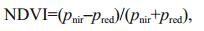 (1)
(1)where pnir is the near-infrared band and pred is the infrared band.
Annual NDVI values were obtained using maximum value composites (White et al., 2016) (Eq.2). This method is advantageous in further reducing the interference of atmosphere, clouds, and solar elevation angle with the calculation results (White et al., 2016). The pixel-based maximum annual NDVI values were calculated using ArcGIS.
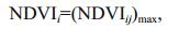 (2)
(2)where NDVIi is the NDVI value in the i-th year and NDVIij is the NDVI value on the j-th day in the i-th year.
(2) NDVI per unit area
The mNDVI was chosen to characterize regional vegetation cover and growth conditions (Liu et al., 2014). Here the unit area refers to a pixel, that is, 30 m×30 m for TM images (Eq.3):
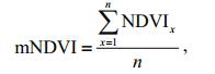 (3)
(3)where n is total number of pixels.
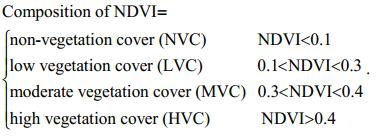
(3) Spatial composition of NDVI
The pixel NDVI values were averaged on the time scale of 1984–2014 to obtain the annual mean. Then the NDVI was ranked to four levels according to the Land Use Map of the Coastal Zone around Jiaozhou Bay and Surrounding Inland Areas(1986, 1995, 2005, 2013):
(4) Spatial distribution of NDVI trends
The Mann-Kendall non-parametric test does not require the sample to follow a certain distribution and is not subject to interference by few outliers or missing values (Liu et al., 2010). Therefore, this test has flexible requirements of data and is used extensively in ecology (Liu et al., 2010; Cui and Shi, 2012; Kisi and Ay, 2014). In this study, we employed the MannKendall test to generate the distribution map of NDVI trend.
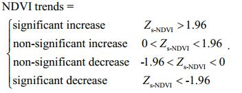
In the Mann-Kendall non-parametric test (Kisi and Ay, 2014), the NDVI values of each pixel for 1983– 2014 were taken as a time series of data, and the statistical quantity Zs was used as the NDVI decrease index for unit pixel. The cut-off value to determine the significance of NDVI trend was |Zs|=1.96 (confidence level < 0.05). The trends of NDVI were divided into the following four types as follows:
In contrast to the short-term impacts of extreme natural disasters in the sea area, sea-land climate change exerts a long-term impact on the land vegetation in the coastal zone around Jiaozhou Bay. Thus, we selected average daily average temperature and average annual precipitation as the indicators to reflect the sea-land climate changes in the Jiaozhou Bay.
The basic meteorological data used to calculate the climate change were mainly derived from the National Meteorological Center of China Meteorological Administration (http://www.cma.gov.cn/) and the Jiaozhou Bay Station of the Institute of Oceanology, Chinese Academy of Sciences (Qingdao, China). According to the data from meteorological stations in the sea and land areas of Jiaozhou Bay, we divided the coastal zone around Jiaozhou Bay using the Thiessen polygon method and obtained the spatial distribution of meteorological stations in the study area. The area weight method was used to calculate daily precipitation (or temperature) in the coastal zone around Jiaozhou Bay using the following formula:
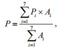 (4)
(4)where P is daily precipitation in the coastal zone around Jiaozhou Bay including the land and sea areas, unit: mm (or ℃ for temperature); Pi is daily precipitation of meteorological station in the land and sea areas, unit: mm (or ℃ for temperature); Ai is the area with the meteorological station, unit: km2.
3 RESULT 3.1 Spatio-temporal changes of NDVI in the coastal zone 3.1.1 Interannual changes in mNDVIThe mNDVI values ranged from 0.32 (1983) to 0.47 (1995) in the coastal zone, with an average annual of 0.39 for 1983–2014. The results of regional average and annual regression analysis revealed a weakly reducing trend of mNDVI over the past 31 years and the slope of the regression line was -0.000 6 (Fig. 5). Correlation analysis was performed on results of land-use change in the coastal zone and interannual change in NDVI. Based on the relationship between land-use change and vegetation cover change, the level of mNDVI changes was related to the degree of urbanization in the coastal zone (R=0.63, P < 0.1).

|
| Figure 5 Temporal trend of mean normalized difference vegetation index (mNDVI, per unit area) in the coastal zone around Jiaozhou Bay, China (1986– 2013) |
Among the three regions around Jiaozhou Bay, the coastal region, which was associated with the highest rate of urbanization (almost 30% construction land), had the lowest average annual mNDVI (0.29). The coastal-inland transition region had higher average annual mNDVI than the coastal zone (0.40 vs. 0.29). In the transition region, agricultural land such as cropland constituted a high proportion ( > 80%), of the area, while construction land took a low proportion ( < 15%). The total land area of the inland region was mainly constituted by agricultural land such as cropland ( > 86%), where average annual mNDVI reached the highest level. Contiguous cropland of higher grade was mainly distributed in the central and western plains around Jiaozhou Bay. For 1983–2014, the spatial distribution of average annual mNDVI showed a sea-land gradient, with gradual increases from coastal to inland areas. The regional divisions ranked: coastal region < coastal-inland transition region < inland region.
The analysis of interannual changes revealed a declining trend in the temporal change rate of mNDVI in various regional divisions. The temporal changes in mNDVI also showed a sea-land gradient and were diminished gradually with increasing distance from the sea. This result suggests that the changes in mNDVI were constantly slowing down with the progression of urbanization. Spatially, the level of mNDVI changes ranked: coastal region > coastalinland transition region > inland region.
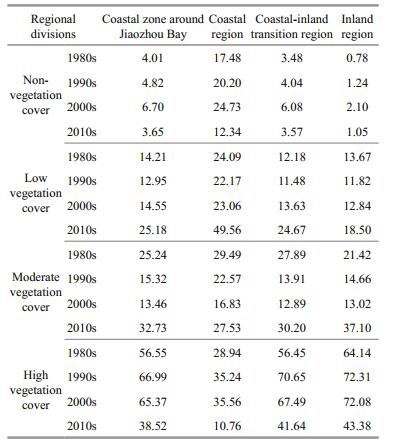
3.2 Spatial changes of NDVI composition in the coastal zoneThe temporal trend of NDVI composition in the coastal zone around Jiaozhou Bay is shown in Table 1. The area ratio of non-vegetation cover (NVC) first increased before decreasing, whereas the area ratio of low vegetation cover (LVC) exhibited an upward trend, with a remarkable increase (73%) after the 2000s. The area ratio of moderate vegetation cover (MVC) displayed a trend of increasing after decreasing, opposite to that of NVC. The area ratio of high vegetation cover (HVC) was been greatly reduced (42%) after a small rise in the coastal zone.
|
The spatial distribution of NDVI composition displayed significant spatial variability in the coastal zone (Fig. 6): NDVI gradually increased from the original central districts of various administrative divisions to the distant agricultural land or natural vegetation. In other words, NDVI gradually expanded outwards with central districts as the core, forming a circular or semi-circular gradient of "NVC/LVCLVC-MVC".

|
| Figure 6 Distribution map of normalized difference vegetation index (NDVI) composition in the coastal zone around Jiaozhou Bay |
NVC was distributed mainly in the original central districts and various coastal functional areas around Jiaozhou Bay. These functional areas included salt industry area in the northwest, tidal flat culture area in the north, port construction area in the east and south, and industrial town construction area along the coast. It is worth noting that newly added construction land due to sea reclamation and the adjacent areas were also the main distribution area of NVC, such as the high-tech zone in the north of the bay and the Qianwan Port in Huangdao near the mouth of the bay.
LVC was distributed mainly inside and around the original central districts in various administrative divisions. Moreover, LVC was observed in scattered towns with lower green levels, bare and sparsely vegetated lands in Daze Mountain in Pingdu and west of Laoshan Mountain in the Laoshan District, and water bodies (mountain water reservoirs and ponds). For the coastal region around Jiaozhou Bay, LVC was distributed in the areas of Laoshan bordering the districts of Shinan and Shibei, in the vicinity of the Huangdao District of Qingdao Municipality. MVC was located mainly in the periphery of LVC area in various central districts, major urban and rural roads such as the Jiqing and Qinglan Expressway, and forestry areas such as Mountain Lao. HVC was mainly distributed in forestry and agricultural areas.
Furthermore, the gradient change of vegetation cover was characterized by gradual increases from coastal to inland areas. The distribution of NDVI therefore showed a typical trend of increasing from coastal to inland areas. The composition of NDVI concerning the area ratio of different types of vegetation cover shows substantial differences across the regional divisions around Jiaozhou Bay (Table 1). The area ratio of NVC ranks coastal region (10% or higher) > coastal-inland transition region (3%–7%) > inland region (0.5%–3.2%). For the area ratio of LVC, the coastal region was markedly higher than the other two regions. There were no significant differences in the area ratio of MVC between the three regions around Jiaozhou Bay. A significant stratification was present in the area ratio of HVC between the coastal and coastal-inland transition regions, and the value was markedly lower than the latter region.
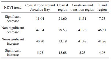
3.3 Spatial distribution of NDVI trends in the coastal zoneAcross coastal zone around Jiaozhou Bay, there was no obvious difference in the area ratio between the NDVI increase and decrease areas (including significant and non-significant trends) from 1983 to 2014 (Table 2). NDVI increase and decrease areas totally constituted 47.63% and 53.37% of the total area of the coastal zone, respectively. Significant increase of NDVI took place in a markedly smaller area than significant decrease of NDVI, 5.93% vs. 11.04% of the total land area of the coastal zone.
|
The spatial distribution of NDVI trends in the coastal zone is illustrated in Fig. 7. Significant decrease of NDVI was mainly found in the eastern plain on the east coast of Jiaozhou Bay, coastal area around Laoshan Mountain, district area of Huangdao to west of the S208 provincial highway, shore area of the Dagu River watershed, central districts in the coastal-inland transition and inland regions, and provincial highways (along highways and intersection regions). Significant increase of NDVI mainly occurred in coastal areas around Jiaozhou Bay and natural and cultural landscape protection areas such as Daze Mountain in Pingdu, Laoshan Mountain in Qingdao, and Dazhu and Xiaozhu Mountains in Jiaonan. Non-significant reduction of NDVI was distributed mainly in agricultural land or natural vegetation transition zone surrounding the significant decrease area. Non-significant increase of NDVI is distributed mainly in agricultural production areas in plains.

|
| Figure 7 Distribution map of normalized difference vegetation index (NDVI) trends in the coastal zone around Jiaozhou Bay |

|
| Figure 8 Schematic of the mechanism underlying the environmental impact of natural and human factors in the coastal zone around Jiaozhou Bay |
The above results reveal that NDVI trends showed a circular or semi-circular gradient of spatial change from the original central districts of various administrative divisions to the distant agricultural land or natural vegetation, i.e., "significant/nonsignificant increase – significant decrease – nonsignificant decrease – non-significant increase".
Moreover, the NDVI trends exhibited different responses to regional development in the newly added construction land due to sea reclamation. Specifically, there was a trend of significant increase in the NDVI values of newly added construction land in the hightech zone in the north of the bay. In contrast, significant decrease of NDVI values occured in large areas of the Qianwan Port in Huangdao and the adjacent areas near the mouth of the bay.
Over the past three decades, urban development has resulted in substantial NDVI changes in more than ~10% area of the administrative divisions of Qingdao. Meanwhile, the area ratio of significant decrease area was markedly larger than that of significant increase area of NDVI. The area ratio of marked monotonous NDVI changes varied substantially with regional divisions and ranked coastal region > coastal-inland transition region > inland region. This result indicates that a sea-land decrease in the area of regions underwent significant changes (including significant increase and decrease) in the vegetation.
4 DISCUSSIONIn order to identify out and quantify the main cause of NDVI changes in the coastal zone around Jiaozhou Bay, we performed a Pearson correlation analysis on natural factors (average annual temperature and total annual precipitation of sea and land areas) and human factors (rate of urbanization).Owing to the limitations of data acquisition, the duration and frequency of time series data used in this analysis were inconsistent. Therefore, we generated data samples of two correlated variables, (NDVI1, y1), (NDVI2, y2), (NDVI3, y3), …, (NDVIn, yn), by permutation and combination of data in accordance with the time series. Next, we calculated the Pearson coefficients for NDVI and variables Y (mainly involving average annual temperature of the land and sea areas, total annual precipitation of the land and sea areas, and rate of urbanization) as follows:
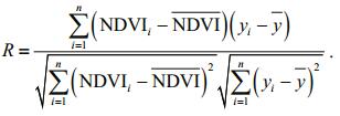 (5)
(5)The positive and negative correlations between NDVI and variables Y were determined as follows:
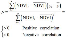 (6)
(6)The following findings were obtained by Pearson correlation analysis between the NDVI in various regional divisions of the coastal zone around Jiaozhou Bay and the indicators (average annual temperature and total annual precipitation) of sea-land climate change:
In the coastal region, the NDVI was significantly correlated with air temperature (R=0.55, P < 0.01), while its correlation with annual precipitation was lower (R=0.33, P < 0.1). The NDVI and the climatic factors in the sea and land areas were correlated negatively. These indicate that the sea-land climate change exerts a certain negative impact on the vegetation growth in the land area.
With regard to the regional distribution of the correlation, there were lower correlations between NDVI and climatic factors (temperature and precipitation) in the coastal-inland transition region (R=0.30 and 0.23, respectively) and inland region (R=0.36 and 0.03, respectively) compared with the coastal region. That is, sea-land climate change exerts a stronger impact on vegetation cover in the coastal region around Jiaozhou Bay, while the impact is less significant for vegetation cover in the non-coastal coastal-inland transition region and inland region.
Agricultural crops and urban artificial vegetation are the major vegetation types in the coastal zone around Jiaozhou Bay. Since the growth of vegetation mainly depends on irrigation water in this area, the precipitation changes exerts little impact on the vegetation compared to temperature changes.
4.2 Impact of land-based human activities on NDVI 4.2.1 Negative impact of land-use change on NDVIThe results of Pearson correlation analysis in regional divisions revealed that the NDVI was significantly negatively correlated with the rate of urbanization in the coastal region (R=0.61, P < 0.01). However, there were poor correlations between these two indicators in the coastal-inland transition region (R=0.03) and inland region (R=0.10) around Jiaozhou Bay.
According to the spatial distribution of NDVI changes and combined with the trends of land-use change in the coastal zone around Jiaozhou Bay, we have found that the significant reduction of NDVI mainly occurred in construction land newly added and extended along the coastline towards the inland over the period of 1983–2014. The range of construction land has been constantly expanding in the coastal region, along with several large-scale revolutions of urban development over the past three decades, such as the eastward migration of municipal government, the "Two-Point – One-Ring" Deployment on the east and west coasts of Jiaozhou Bay, and the development of the High-Tech Zone in the north and the Blue Silicon Valley in the east. The above construction land has been taking place of agricultural land or natural vegetation land, posing significant negative effects on the ecological stability of regional vegetation.
Sea reclamation is a unique way to expand construction land in the coastal zone, which exerts a significant impact on the NDVI. First, sea reclamation project results in land-use transfer from seawater to construction land. Meanwhile, there is an increasing trend in the NDVI in local areas, as the NDVI of construction land is much higher than that of seawater. Second, the land newly added by sea reclamation is used mostly for construction of port (e.g., Qianwan Port in Huangdao) and industry (e.g., high-tech zone in the north) around Jiaozhou Bay. The newly developed area is often larger than the reclaimed area. Therefore, the adjacent areas of sea reclamation project are often developed into construction land, resulting in the lower vegetation cover in the above areas.
4.2.2 Positive impact of ecological engineering on NDVIWith regard to the spatial distribution of significant increase area of NDVI, the coastal region can be divided into two parts: one is the new urban green space such as parks and green belts along roads in urbanized areas; the other is the original dense vegetation area, such as Mt. Lao. These vegetation areas constitute the majority of NDVI increase area in the coastal region around Jiaozhou Bay.
In terms of the distribution of the NDVI increase area, the current ecological engineering constructed in Qingdao is related to the NDVI increase, such as the green renovation project in old districts and the "Green Mountain" ecological project in Laoshan District. In order to limit the adverse effects arising from the expansion of urban construction land on the reduction of agricultural production land, Qingdao is gradually building complex urban and rural ecological space comprising crop land, forest land, park land, grass land, and waters including territorial water bodies and the sea. Further, strictly limiting the new reclamation engineering plays a positive role in the increasing trend of NDVI in the coastal region.
Thus, the positive effect of the ecological engineering on the NDVI increase to some extent can constrain and offset the negative effects of rapid urbanization in the study area. The ecological engineering plays an important role in building the vegetation ecological security framework in the coastal zone around Jiaozhou Bay.
4.3 Comprehensive analysisVegetation, as an important type of resources in the ecosystem, holds an irreplaceable position in the regional ecological security system and indicates the condition of regional ecological security. Land vegetation cover in the coastal zone around Jiaozhou Bay demonstrates a certain response relationship to sea-land climate change and land-based human activities. However, within a certain time scale (1983–2014 in the present study, i.e., a rapid urbanization stage), the impact of land-based human activities is slightly greater than that of sea-land climate change for land vegetation cover.
With respect of natural factors, the sea has a high heat capacity value and thus plays a major regulatory role in the process of climate change. Given that all radiactive dielectrics are constant, the atmospheric temperature slowly rises at a lower level than the temperature rise on the land surface because of the slow response of the sea (Kevern, 2009; Dudley et al., 2016). This regulatory role of the sea has a significant impact on the differentiation of climate change in coastal zones. Meanwhile, sea-land transition inevitably occurs in coastal zones. Different physical properties of the sea-land underlying surface, in the presence of sea-land transition and division, result in certain sea-land humidity zonality. Under the combined effect of the above two factors, climate change shows significant sea-land gradient features in the coastal zone around Jiaozhou Bay, and this effect is gradually strengthened with a decrease in the distance toward the sea. The vegetation index, which sensitively responds to climate change, also exhibits a typical sea-land gradient under the effect of sea-land gradient features of climate change.
With respect of human factors, as construction land with high imperviousness is gradually replaced with natural land, the original vegetation types and cover in urban areas are constantly reduced during urbanization. This impact is more significant in coastal cities where land resources are scarce. The natural habitats of coastal vegetation gradually decay or disappear, the spatial distribution of which displays significant spatial decreases from coastline around Jiaozhou Bay to inland. Sea reclamation achieves land resources from the sea while changing the original vegetation cover in peripheral areas: it is one of the major construction activities leading to significant vegetation decay in coastal cities. Meanwhile, with increasing importance attached to the natural regulatory role of vegetation, the proportion of artificial greenery has been gradually increased in the process of urban reconstruction, this has become an effective way to restore vegetation cover in urban areas. The effect of land-based human activities has shown dual character for vegetation cover in the coastal zone around Jiaozhou Bay. Over the study period of 1983–2014, significant decrease of NDVI mainly occurred in newly added and expanded construction land. Owing to the continuous implement of ecological engineering, the NDVI trends also displayed significant increase to varying degrees in partial areas of the coastal zone.
5 CONCLUSIONIn this study, we found that vegetation cover, in terms of NDVI, exhibited a sea-land gradient under the impact of urbanization in Jiaozhou Bay over the period 1984–2014. The vegetation cover spread towards the sea and decayed around the sea, representing a unique pattern in coastal zone. Under the influence of land-based human activities and sealand climate change, the vegetation cover was remarkably changed in the coastal region around Jiaozhou Bay. Compared with inland cities, the contradiction was more evident between the construction land expansion and moderate or high vegetation cover in the coastal cities, which exhibited a sea-land gradient extending around the coastline to the inland. The above progress has accelerated the environment change in the coastal region and intensified the vulnerability of regional coastal environment.
Both sea-land climate change and land urbanization are dynamic processes. Along with the acceleration of global climate change and future urbanization, the pattern of vegetation cover change will continue to undergo significant changes in the coastal zone around Jiaozhou Bay. In the context of global warming, sealand climate change characterized by temperature rises exerts a typical negative impact on vegetation in the coastal zone. The range of distribution, abundance, and seasonal activities of plants may have changed for adaptation to climate change. Meanwhile, the level of vegetation cover will be further reduced due to intense and frequent land-based human activities, thereby exerting a stronger negative impact in the coastal zone compared to the inland zone.
During the progress of urbanization, it is essential to identify the inherent patterns of spatial-temporal changes in coastal urban vegetation, develop positive ecological policies, and build a vegetation ecological security framework suitable for the characteristics of coastal resources. These strategies will buffer the negative eco-environmental impacts arising from sealand climate change and human activities on land, in order to achieve the balance of regional development and ecological benefits.
| Aich V, Liersch S, Vetter T, Fournet S, Andersson J C M, Calmanti S, van Weert F H A, Hattermann F F, Paton E N, 2016. Flood projections within the Niger River Basin under future land use and climate change. Science of The Total Environment, 562: 666–677. Doi: 10.1016/j.scitotenv.2016.04.021 |
| Bateman I, Agarwala M, Binner A, Coombes E, Day B, Ferrini S, Fezzi C, Hutchins M, Lovett A, Posen P, 2016. Spatially explicit integrated modeling and economic valuation of climate driven land use change and its indirect effects. Journal of Environmental Management, 181: 172–184. Doi: 10.1016/j.jenvman.2016.06.20 |
| Cochrane K, De Young C, Soto D, Bahri T. 2012. Climate change implications for fisheries and aquacultureoverview of current scientific knowledge. Jia Y, Guo S, Zhu Y Q, Luo S T, Trans. China Agriculture Press, Beijing, China. 10p. (in Chinese) |
| Cui L L, Shi J, 2012. Urbanization and its environmental effects in Shanghai, China. Urban Climate, 2: 1–15. Doi: 10.1016/j.uclim.2012.10.008 |
| Domingues C M, Church J A, White N J, Gleckler P J, Wijffels S E, Barker P M, Dunn J R, 2008. Improved estimates of upper-ocean warming and multi-decadal sea-level rise. Nature, 453(7198): 1090–1093. Doi: 10.1038/nature07080 |
| Dudley P N, Bonazza R, Porter W P, 2016. Climate change impacts on nesting and internesting leatherback sea turtles using 3D animated computational fluid dynamics and finite volume heat transfer. Ecological Modelling, 320: 231–240. Doi: 10.1016/j.ecolmodel.2015.10.012 |
| Eckert S, Hüsler F, Liniger H, Hodel E, 2015. Trend analysis of MODIS NDVI time series for detecting land degradation and regeneration in Mongolia. Journal of Arid Environments, 113: 16–28. Doi: 10.1016/j.jaridenv.2014.09.001 |
| Gao Z H, Yang D F, Qin J, Xiang L H, Zhang K, 2008. The land-sourced pollution in the Jiaozhou Bay. Chinese Journal of Oceanology and Limnology, 26(2): 229–232. Doi: 10.1007/s00343-008-0229-7 |
| Hou X Y, Zhang A D, Wang C Y, Wang Q X, Ying L L, 2010. Progress of studies on coastal land-based non-point source pollution. Progress in Geography, 29(1): 73–78. |
| Huang Y F, Li F Y, Bai X M, Cui S H, 2012. Comparing vulnerability of coastal communities to land use change:analytical framework and a case study in China. Environmental Science & Policy, 23: 133–143. Doi: 10.1016/j.envsci.2012.06.017 |
| Kevern C, Cassandra D Y, Doris S, Tarub B. Overview of current scientific knowledge. In: Kevern C ed. Climate Change Implications for Fisheries and Aquaculture. China Agriculture. Press, China. p. 10. |
| Kisi O, Ay M, 2014. Comparison of Mann-Kendall and innovative trend method for water quality parameters of the Kizilirmak River, Turkey. Journal of Hydrology, 513: 362–375. Doi: 10.1016/j.jhydrol.2014.03.005 |
| Liu Q P, Yang Y C, Tian H Z, Gu L, Zhang B, 2014. Spatialtemporal difference of vegetation changes in built-up areas in China during the period of rapid urbanization. Journal of Natural Resources, 29(2): 223–236. Doi: 10.11849/zrzyxb.2014.02.004.(inChinesewithEnglishabstract) |
| Liu Y L, Wang Q, Bi J Z, Zhang M M, Xing Q G, Shi P, 2010. The analysis of NDVI trends in the coastal zone based on Mann-Kendall test:a case in the Jiaodong Peninsula. Acta Oceanologica Sinica, 32(3): 79–87. |
| Machwitz M, Gessner U, Conrad C, Falk U, Richters J, Dech S, 2015. Modelling the gross primary productivity of west Africa with the Regional Biomass Model RBM+, using optimized 250 m MODIS FPAR and fractional vegetation cover information. International Journal of Applied Earth Observation and Geoinformation, 43: 177–194. Doi: 10.1016/j.jag.2015.04.007 |
| Nguyen T T X, Bonetti J, Rogers K, Woodroffe C D, 2016. Indicator-based assessment of climate-change impacts on coasts:a review of concepts, methodological approaches and vulnerability indices. Ocean & Coastal Management, 123: 18–43. Doi: 10.1016/j.ocecoaman.2015.11.022 |
| Petrosillo I, Semeraro T, Zaccarelli N, Aretano R, Zurlini G, 2013. The possible combined effects of land-use changes and climate conditions on the spatial-temporal patterns of primary production in a natural protected area. Ecological Indicators, 29: 367–375. Doi: 10.1016/j.ecolind.2013.01.025 |
| Qingdao Municipal Administration of Land, Resources & Housing. 2011. The Qingdao municipal land use plan(2006-2020). Qingdao Municipal Government Release 22-90, 30 December 2011, http://www.fdzy.gov.cn/fdzy/contentAction.do?itemID=6360. Accessed on 2011-12-31. (in Chinese) |
| Qingdao Municipal Urban Planning Bureau. 2008. The Qingdao City Master Plan (2006-2020). Qingdao Municipal Government Release 1-29, 20 October 2008, http://upb.qingdao.gov.cn/qdupb/news/2008102115425947254.shtml. Accessed on 2008-10-21. (in Chinese) |
| Scherner F, Antunes Horta P, de Oliveira E C, Carlos Simonassi J, Hall-Spencer J M, Chow F, Nunes J M C, Barreto Pereira S M, 2013. Coastal urbanization leads to remarkable seaweed species loss and community shifts along the SW Atlantic. Marine Pollution Bulletin, 76(1-2): 106–115. Doi: 10.1016/j.marpolbul.2013.09.019 |
| Wang J, Hong H S, Zhou L M, Hu J Y, Jiang Y W, 2013. Numerical modeling of hydrodynamic changes due to coastal reclamation projects in Xiamen Bay, China. Chinese Journal of Oceanology and Limnology, 31(2): 334–344. Doi: 10.1007/s00343-013-2109-z |
| Wang N, Zhang L Q, Yuan L, Cao H B, 2012. Research into vulnerability assessment for coastal zones in the context of climate change. Acta Ecologica Sinica, 32(7): 2248–2258. Doi: 10.5846/stxb201109291437.(inChinesewithEnglishabstract) |
| Wen L, Saintilan N, Yang X H, Hunter S, Mawer D, 2015. MODIS NDVI based metrics improve habitat suitability modelling in fragmented patchy floodplains. Remote Sensing Applications:Society and Environment, 1: 85–97. Doi: 10.1016/j.rsase.2015.08.001 |
| White D C, Lewis M M, Green G, Gotch T B, 2016. A generalizable NDVI-based wetland delineation indicator for remote monitoring of groundwater flows in the Australian Great Artesian Basin. Ecological Indicators, 60: 1309–1320. Doi: 10.1016/j.ecolind.2015.01.032 |
| Yang F, Matsushita B, Fukushima T, Yang W, 2012. Temporal mixture analysis for estimating impervious surface area from multi-temporal MODIS NDVI data in Japan. ISPRS Journal of Photogrammetry and Remote Sensing, 72: 90–98. Doi: 10.1016/j.isprsjprs.2012.05.016 |
| Zeng H, Chen X, 2010. An analysis on eco-environmental effect of vegetation in urbanized areas. Ecology and Environmental Sciences, 19(11): 2737–2742. Doi: 10.3969/j.issn.1674-5906.2010.11.039 |