Institute of Oceanology, Chinese Academy of Sciences
Article Information
- RAN Weimin, LUAN Xiwu, LU Yintao, LIU Hong, YANG Jiajia, ZHAO Yang, HE Wenchang, YAN Zhonghui
- Formation and evolution of the tertiary carbonate reefs in the Madura Strait Basin of Indonesia
- Journal of Oceanology and Limnology, 37(1): 47-61
- http://dx.doi.org/10.1007/s00343-018-7394-0
Article History
- Received Dec. 28, 2017
- accepted in principle Feb. 8, 2018
- accepted for publication Apr. 11, 2018
2 Evaluation and Detection Technology Laboratory of Marine Mineral Resources, Qingdao National Laboratory for Marine Science and Technology, Qingdao 266071, China;
3 Qingdao Institute of Marine Geology, Qingdao 266071, China;
4 Petro China Hangzhou Research Institute of Geology, Hangzhou 310023, China;
5 China Petroleum Pipeline Engineering Co., Ltd. (Engineering), Langfang 065000, China;
6 China University of Petroleum, Qingdao 266071, China
Reefs, are mound-like marine biogenic carbonate rocks, formed over a long period of time by coral and other marine organisms through physical, chemical and biochemical reactions (Read, 1985). Requirements for growth conditions for coral reefs (i.e., that they flourish in sea water with temperature of approximately 20–30℃ salinity of 27–40, and water depth of 0–50 m, as well as abundant sunlight and relatively weak hydrodynamic forcing at the same time) (Nayoan et al., 1981; Fontaine et al., 1987; Handford and Loucks, 1993; Jin et al., 2013), we can reconstruct paleo-sedimentary environment, thus giving guidance for restoring paleo-landforms and environments in geological history (Yu et al., 2004; Eberli et al., 2004; Wu et al., 2009; Zhu et al., 2015).
Reefs are an important component of carbonate hydrocarbon reservoirs (Wei et al., 2006; Zou et al., 2015). Reef limestones, are mainly composed of aragonite and calcite, with a decrease in pores in protistan skeletons in the rock structure; therefore, reefs show an excellent physical condition with a high level of porosity, permeability and saturation, which contributes to the formation of large oil and gas reservoirs (Wilson, 2002, Gu et al., 2009). Total hydrocarbon reserves of major reef oilfields amount to more than 40×108 t; therefore, research on reefs has been a hot issue for oil and gas exploration all over the world (Wei et al., 2006; Zou et al., 2015).
Reef reservoirs with huge reserves have been found in Canada and the Gulf of Mexico (Zou et al., 2015). Studies of the Bahamas Banks off North America have greatly improved the knowledge of sedimentation and diagenesis of reef carbonate systems (Grammer et al., 1993). A large oil and gas region found in Xinjiang province, which is trapped by Paleozoic reefs, holds reserves of 10×108 t of oil equivalent, and the natural gas reserves of the whole reef show several trillion steres (Wei et al., 2006). In addition, Paleozoic reef reservoirs with enormous reserves have been discovered in the Sichuan Basin in China. Due to favorable reef-building conditions in the South China Sea, 12 basins containing Cenozoic carbonate reefs have been found, some of which have oil and gas reservoirs (Xu et al., 2012; Fan, 2015; Li et al., 2015; Zhu et al., 2015). Detailed theory researches have been conducted on the types, spatial-temporal distribution, controlling factors of the carbonate reefs in South China Sea (Yang et al., 2017a, b). Similar to the South China Sea in terms of environmental conditions, many Cenozoic carbonate reefs in southeast Asia have been explored (Kusumastuti et al., 2002; Satyana, 2002, 2005; Sharaf et al., 2005). This paper aims to give a further understanding on reef research through the analysis of the growth and evolution, distribution characteristics, development types and models of Tertiary carbonate reefs in the Madura Strait Basin (MSB) in Indonesia. Hopefully this paper can help oil and gas exploration in the future.
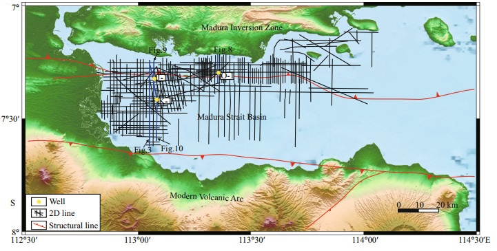
2 REGIONAL GEOLOGICAL SETTINGSoutheast Asia, located at the junction of three big plates (i.e., the Eurasian plate, the Indian plate, and the Pacific plate), is one of the most active regions of tectonic movement and ocean current movement on Earth (Fig. 1). That is why, currently, a large number of marine geological and physical oceanography experts are attracted and pay attention to studies on this hotspot. In this paper, the study area commonly referred to as the MSB (Fig. 2) is part of the East Java Basin, which is situated along the southeast margin of Eurasia (Hamilton, 1979; Tapponnier et al., 1986; Hall, 1996, 1997). The northern margin of the MSB is defined by a structurally complex zone called the 'Madura inversion zone', which was first interpreted as a major backthrust that runs the length of Java Island (Simandjuntak and Barber, 1996); this study reported that it became active in Early Miocene time, and some segments are currently still active and bounded to the south by the east-west trending Southern Mountains volcanic arc, which was built on a Gondwana-derived continental fragment (Zhu et al., 2004; Kopp et al., 2006; Smyth et al., 2007; Clements et al., 2009; Clements and Hall, 2011). The MSB is situated between these two major tectonic elements.

|
| Fig.1 Location of the study area (red box) within southeast Asia Main and relative regional tectonic units are marked by black solid lines and dotted lines, respectively. EJ-WS: East Java-West Sulawesi; MI: Madura Island; MVA: modern volcanic arc; SMA: Southern Mountains arc; BI: Bali Island; LI: Lombok Island; SI: Soembawa Island. The East Java Basin is limited by the green polygon. |
|
| Fig.2 Location of the Madura Strait Basin Main micro-tectonic units have been separated by two red solid lines and several triangles based the two main thrust structures. The three yellow dots represent three wells: J-1, K-1 and O-1. The blue lines represent the interpreted seismic lines shown in this paper. |
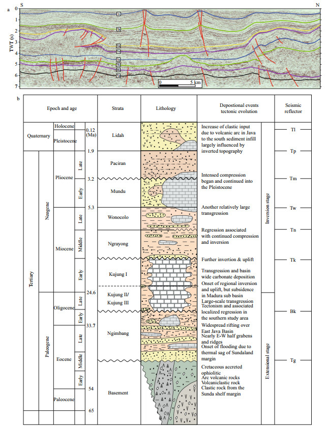
In the Middle Eocene, the Indo-Australian plate started subducting beneath Sundaland, which created the NE-SW trending back arc rift basin in the East Java Basin. The direction of subduction of the Indo-Australian plate changed in the Oligocene and changed the orientation of the rift basin to E-W direction. At the same time, it caused transgression and further inundation in the study area. Basin-wide marine carbonate sediments deposited and many coral reefs developed due to the suitable environment of the southern MSB. However, large scale thrusting was considered to have taken place in the Middle Miocene (~15 Ma) or later throughout the East Java Basin (Clements et al., 2009) due to the collision and extrusion between the Indo-Australia plate and the Eurasian plate. Normal faults formed in the early stage transited into reversed faults and became positive inversion structures. Since the late Pliocene (at approximately 3.5–2 Ma), the collision between the Indo-Australian plate and the northern arc had a long-distance impact on the East Java area, which formed a wide-spread fold and thrust structures. It can be recognized as an obvious Pliocene angular unconformity in the study area. Therefore, the tectonic activities in the study area can be simply divided into two parts during the Cenozoic age: an earlier and continuous extensional rift stage, and a later and successive extrusion inversion stage (Hall, 2002, 2012; Clements et al., 2009; Clements and Hall, 2011; Sevastjanova et al., 2011; Hall and Sevastjanova, 2012) (Fig. 3).
|
| Fig.3 Structural framework interpretation of regional south-north cross profile across the MSB (location in Fig. 2) and a schematic stratigraphic division of the Madura Strait Basin (modified from Matthews and Bransden, 1995; Rutley, 2001; Kusumastuti et al., 2002; Sharaf et al., 2005) |
After nearly one hundred years of geological survey and oil and gas exploration, a number of large and small oil and gas fields have been discovered in the MSB (Sevastjanova et al., 2011; Yang et al., 2011). In addition, many researchers and oil explorers are attracted by this kind of carbonate reservoir, which is either composed of reefs or bioclasts (Kusumastuti et al., 2002; Sharaf et al., 2005). Although the area of such reservoir is relatively small, they have greater oil and gas outputs due to their superior physical properties. Carbonate rock reservoirs usually preserve the geometry of the primary reef growth. This paper will analyze and study carbonate reefs that developed in the Madura Straits Basin, i.e., 'traditional' reefal buildups during the Late Oligocene to Early Miocene, as well as planktonic foraminiferal grainstone accumulations in Early Pliocene times.
3 DATA AND METHODTo describe the distribution, characteristics, depositional environment and other properties of reefs in the study area, over 4 500 km of 2D seismic data (Fig. 2) of variable quality gathered from 1980 to 2000 and carried out by the China National Petroleum Corporation (CNPC) and other foreign companies (Santos and CUE) are used. The seismic profiles basically covered most of the MSB. Parts of the 2D seismic data were reprocessed for 2006–2010. The sampling interval is 4 milliseconds. The well petrophysical data were obtained from the CNPC laboratories and oil companies, including Santos and Cue Energy Resources in Australia. The time-depth relationship, which is used to calculate the depth and thickness of the strata, is corrected by VSP (vertical seismic profiling) data and corrected synthetic seismogram data.
4 WELL CORE CHARACTERISTICS OF TWO DIFFERENT TYPES OF CARBONATE REEFSTwo periods carbonate reefs are discussed in this paper: one was in the early Pliocene, which accumulated in the Mundu Formation, and the other in the Late Oligocene to Early Miocene, which grew during the deposition of the Kujung Formation. The Mundu Formation is mainly composed of bioclastic grainstone, wackestone and packstone and has been intensely bioturbated. After analysing the lithostratigraphy, biostratigraphy and paleo-environments of the core data, we think the Mundu Formation was deposited in a marine shelf environment ranging from the outer shelf facies to the upper bathyal facies. Carbonate bio-framework grains are principally composed of open marine planktonic foraminifera, particularly of Globigerina and other minor carbonate framework components, including small benthonic foraminifera, abraded larger foraminifera, red algae, echinoderm and other organic fragments.
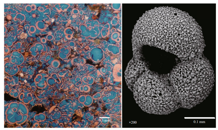
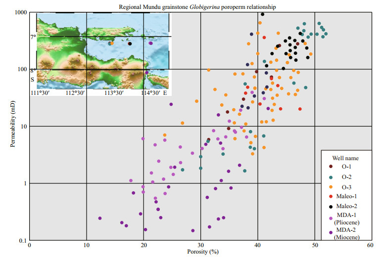
The thin section of the well-sorted Globigerina foraminifera grainstone (Fig. 4) shows that the Mundu Formation has tremendous intragranular and intergranular porosity. Total porosity of the Mundu carbonate rock can reach more than 40%. Well core data from the Globigerina grainstone of the Mundu Formation are shown in a permeability-porosity cross graph (Fig. 5). It shows remarkably high porosity, with an average of approximately 30%, and also high permeability from 10 mD to 1 Darcy. For the above reasons, the Mundu Formation contains unique reservoirs, and many oil and gas have been discovered in the formation in the MSB over the past 15 years (Triyana et al., 2007; Ni et al., 2016; Arifin et al., 2017).
|
| Fig.4 Thin section image of Mundu grainstone (left) and scanning electron microscope (SEM) image of Globigerina foraminifera (right) |
|
| Fig.5 The cross-sectional graph of regional Mundu Globigerina grainstones porosity-permeability Different colour dots represent samples that are taken from diverse wells and sections. |
During the Late Oligocene to Early Miocene, basin-wide carbonate sediments were deposited in the study area, called Kujung Formation. The Kujung Formation is mainly limestone, composed of bioclastic wackestone and packstone, and characteristically includes a relatively high percentage of lime mud matrix, with minor dolomitic limestone, dolostone and calcareous dolostone. The Kujung carbonate rock is mainly in reefal facies, composed of a coral framework, larger foraminifera, red algae, echinoderm plates, and other minor carbonate bioclasts. The Kujung Formation was deposited in a shallow marine shelf environment that ranged from inner neritic proximal facies to shelf slope distal facies, as inferred from the lithostratigraphy, biostratigraphy and paleo-environments of the core data.
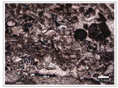
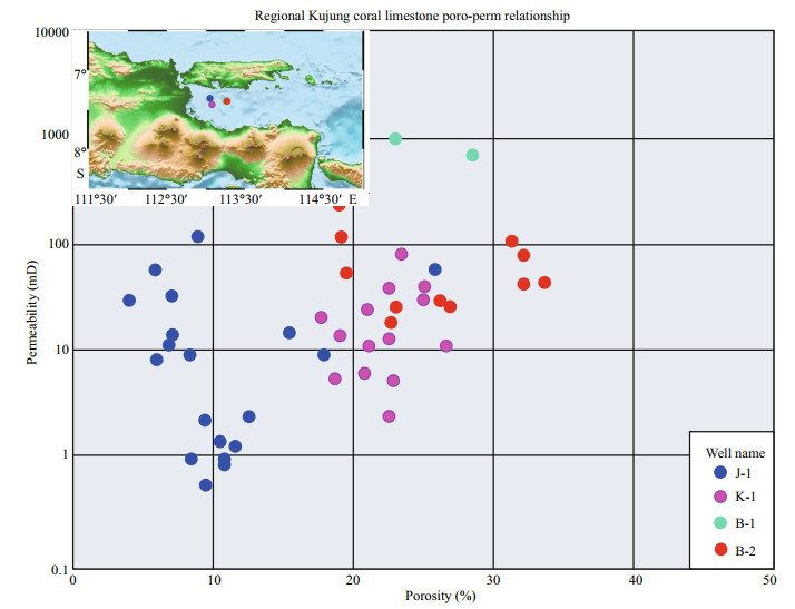
The thin section images of the Mundu grainstone (Fig. 4) and the Kujung limestone (Fig. 6) show that the reservoir properties of Kujung limestone are slightly worse than Mundu grainstone. The Kujung limestone has an abundant amount of recrystallized lime mud or calcite cement, and lacks the large number of Globigerina foraminifera of the Mundu Formation. A permeability-porosity cross plot of core data of Kujung limestones is shown in Fig. 7. It shows overall lower porosity and permeability than the Mundu Formation. The porosity of Kujung limestone usually varies from 15% to 35%, whereas permeability is mostly below 100 mD. Thus, with regard to the permeability and porosity of two kinds of carbonate rocks, the petrophysical properties of the Mundu reservoir (especially for grainstone) are slightly better than those of the Kujung reservoir.
|
| Fig.6 Thin section image of the Kujung coral-limestone |
|
| Fig.7 Cross-plot of Kujung coral limestones porosity-permeability Different colour dots represent samples from different wells and sections. |
Bubb and Hatlelid (1978) classified reefs into four types based on their shape: barrier reefs, which are linear and usually grow off the gradually sloped sea bottom; shelf-margin reefs, which usually accumulate at the shelf edge in the form of a string of beads; patch reefs, which grow on submarine small high structures in offshore shallow seas and form various shapes; and pinnacle reefs, which are usually small and tower shaped. Vail et al. (1977) and Brown and Fisher (1980) indicated that the characteristics of seismic facies reflect partially sedimentary facies, especially for different seismic parameters between adjacent elements. Shapes, sizes and depositional environment of the reefs were interpreted from 2D seismic data. There are two main types of reefal seismic facies in the Tertiary in the study area, with different reflection characteristics.
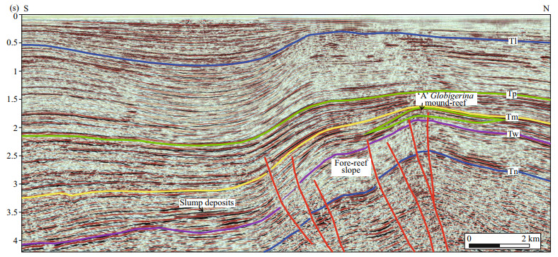
The Mundu Formation carbonate sequences correspond to the interval between seismic markers Tm and Tw. The profile of Fig. 8, which is through the O mound-reef, shows obviously different reflection characteristics in upper and lower parts of the Mundu sequence, as it has high amplitudes, high continuity, parallel reflections, and low and medium frequencies. The thickness of the O mound-reef reaches over 0.2 s two-way time, and the Mundu thickness to the south is slightly larger than that to the north. The O mound-reef displays an asymmetrical mounded shape structure, causing the southern phase axis to be lower than that of the north. Based on the evidence, we have deduced that the O mound-reef initially developed on the margin of the northern platform. Over the O mound-reef to the north, the upper strata displayed a thick middle part and thin flanks onlapping both sides of the Mundu sequence, which caused a small basin to be blocked by the high O mound-reef. The upper sequence draped over the top of the O mound-reef, which caused both sides of the stratigraphic unit to onlap its flanks. An interesting phenomenon on the south side of the O mound-reef is a restricted unit with discontinuous and disorderly reflections and terminated by Tm at the base of the slope, which caused a parallel quadrilateral with stratigraphic units on the upper part of the slope (fore-reef unit on Fig. 8). We inferred that this is likely erosional debris from the O mound-reef that was transported by a tidal or coastal branch. In addition, discontinuous and strong reflections in the interior and the bottom of O mound-reef were identified. The obvious horizontal axis (flat spot) between Tm and Tw inside the O mound-reef is probably an interface of different fluids. Of course, there were also some small mound-reefs controlled by the reverse faults on the south edge of the inversion zone in the western part of the study area, and the faults break through the Mundu Formation. Similar to the O mound-reef, we do not discuss these details (Fig. 9).

|
| Fig.8 Interpretation of 2D seismic profile across the 'O' Globigerina mound-reef The location of the seismic profile is marked in Fig. 2. The O mound-reef is located between the Tw and Tm reflectors, highlighted by black arrow. The interfaces of the light blue and purple lines represent the different fluids contact. The progradational reflection configuration in front of the O mound-reef represents the fore-reef slump deposits. In addition, the onlap reflection configuration behind the O mound-reef shows the back-reef lagoon. |
|
| Fig.9 Interpretation of 2D seismic profile across the 'A' Globigerina mound-reef similar to the 'O' mound-reef The reverse faults break through the Tw and Tm reflectors. |
The Late Eocene-Early Oligocene Kujung formation is a giant sequence of basin-wide carbonate deposition between seismic markers Tk and Bk. On the seismic-profile of Fig. 9, which passes through the J and B reefs, the Kujung units display high amplitudes, high continuity, internally weak parallel reflections, and low and medium frequencies, which are markedly different from its overlying stratigraphic units, which display a weak amplitude, medium continuity, internally weak parallel reflections, and a high and medium frequency. Due to the large burial depth of the Kujung sequence, which locally reaches more than 6s, and the relatively poor quality of the deep profiles, the results are uncertain reflection characteristics for seismic marker Bk.
It can be determined from the profile that the J reef displays an asymmetrical mounded shape (not exactly the same as the O mound-reef), where the northern part of the phase axis is lower than that of the south, while the B reef displays a symmetrical mounded shape to the south of the J reef. Compared to the J reef, which is flat and small, the B reef is taller and bigger. According to the J reef, which is located to the south of the B reef and was developed on a flat platform, we conclude that the J reef was developed on the margin of the platform, and the interpreted reversed fault marked in Fig. 10 was an older normal fault that controlled northern basin deposition. The thickness of the B reef could reach more than 1.1 s for two-way time, but the J reef only reached approximately 0.6 s TWT. It could be simply observed that the upper sequence drapes over the top of both reefs, where both sides of the stratigraphic units onlap the flanks. Although the deeper part of the seismic profile is of poorer quality than the upper part profile, we could still identify that the B reef and the small J reef both display chaotic seismic reflection configurations in the upper part of the sequence in its interior, but they present discontinuous, parallel and strong seismic reflection configurations in the lower part of the sequence. These seem to be significantly different from the O mound-reef in the Mundu Formation, with all kinds of seismic reflection characteristics, including high amplitude, discontinuous continuity, internally strong parallel reflection, and low and medium frequency in the entire O mound-reef. One reason is likely that the components of the reef framework structure are different, which is shown by the planktonic foraminifera grainstone in the O mound-reef but mainly 'reefal' wackestone in the J reef. It is inferred that the other reason could be that reefs contain different fluids with diverse densities, solubilities and viscosities, which can be verified by good logging and geochemical experiments. The slightly upturned Bk axis at the bottom of the B reef was interpreted as small ancient landform uplift due to the observed appropriate water depth for the growth of coral reefs in the late Oligocene.

|
| Fig.10 Interpretation of the 2D composite seismic profile across the 'B' and 'J' coral reefs The B and J reefs have been marked by black arrows. |
|
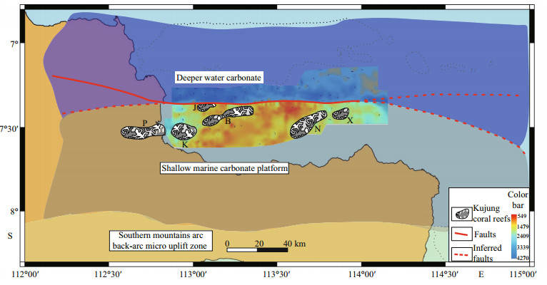
| Fig.11 Stratigraphic thickness map between Tk and Tg All of the identified Kujung coral reefs that developed at the extensional stage are marked with a special pattern. Interpreted depositional environments are shown by different shadow areas. The main fault and its possible extension directions are shown with red lines. |
Detailed analysis of seismic facies gave us insights in the shape, size, and developmental position for the types of reefs that developed during the Tertiary age in the study area. Some reefs grew on an open, flat platform and others developed on the edge of the platform. Undoubtedly, the developmental positions caused diverse types and components of reefs mentioned above. Next, we will discuss and restore the paleo-environments of the above-mentioned reefs by analyzing and studying tectonic evolution and basin development.
6 DISCUSSIONThe study area is known as a back-arc basin, where tectonic-sedimentary evolution may be divided into two stages: back-arc rift and depression basin. The India-Australia plate is subductting beneath Java Island along the Java trench, which was not the position and extension direction of the current. Smyth et al. (2007) indicated that the modern basement of Java Island is composed of the northern Sundaland continental shelf edge, mid-Cretaceous accreted ophiolitic, arc rocks and a southern terrane of Archean continental crust. The southern Archean continental crust was separated from Western Australia, and after a long period of north-ward continental drift before the Cretaceous, it collided and merged with Sundaland, resulting in the cessation of the pre-Cenozoic NE-SW trending subduction and a later retreat of the Cenozoic E-W trending subduction. It was since the middle Eocene that the Cenozoic sedimentary basin, such as the MSB, started to fill with Cenozoic sediments. All reefs discussed above developed after this.
Wilson (1975) first proposed a model of the sedimentary environments of marine carbonate rocks, dividing the carbonate sedimentary environment into nine facies from the transitional zone to the deep marine zone. The 1980 volume of AAPG published a comprehensive and systematic series of textbooks on the seismic facies of clastic and carbonate rocks in marine strata. However, Fontaine et al. (1987) noted that it is unrealistic and difficult to identify all facies in seismic profiles because of seismic resolution restrictions. Consequently, this study will be based on these basic models of sedimentary facies, in combination with the above identified seismic facies and well core facies to restore ancient landforms and the cause of Tertiary reef growth and evolution.
As a result of subduction of the India-Australia plate, the formation of the widely distributed Sunda-Banda volcanic arc occurred at an active continental margin, which created back-arc extensional basins. The MSB, including the whole East Java Basin represents one of these back-arc basins, filled with thick fluvial and lacustrine sediments of the Ngimbang Formation, which were mainly derived from the Sunda shelf. Although the southern volcanic arc had begun to intrude and uplift the upper continental crust, the large number of braided streams that developed on the margin of the Sunda shelf made great contributions to the sediments fill of the basin. A series of NW-SE trending large normal faults in the northern part of the MSB controlled early deposition. From the late Eocene to the early Oligocene, Longley (1997) considered that the subduction direction of the India-Australia plate changed to the north with the counter clockwise rotation of the Eurasian plate, and we infer that this shifted the structural trend of the study area towards the E-W direction. Early normal faults also changed to nearly E-W and were continuously active. Meanwhile, the occurrence of a large-scale transgression in the study area had happened, which caused basin-wide carbonate deposition. This begs the question of the existence and development of the J and B reef described above during this period.
From our perspective, the rapid increase in sea level rise is the most significant reason for the basin-wide carbonate deposition, especially in the southern part of the study area. The continuously active E-W faults moved to the north (i.e., growth faults), which probably limited the transportation of fluvial and lacustrine sediments to the south. Additionally, the source of the supply rate for sediments from the Sunda shelf during this period is not very clear and needs to be further studied. In addition to the above two reasons, the southern continuous uplift of the volcanic arc resulted in the uplift of the basin, especially in the southern part of the study area.
6.1 The formation of the B and J coral reefs in Late Oligocene to Early MioceneBy means of a stratigraphic thickness analysis to restore the sedimentary facies of the Kujung carbonate strata and the growing paleo-environment of the B and J reefs. Also the stratigraphic thickness map between the Tk and Tg seismic markers to reflect the regional deposition at the extensional stage in the study area. In the southern part depositional thickness was thinner than in the northern part of the MSB, suggesting that the paleo-topography in the south was higher than in the north. In addition, a series of E-W trends for normal faults located on the most obvious dividing line for thickness variations separated the study area into two parts, which also indicated that the sedimentary center was to the north of the MSB during the extended period of the back-arc basin.
Our analysis in the last section indicated that the B reef was located on a relatively flat place, and the J reef was situated on the margin of a flat region to the north of the B reef. To summarize, suggesting that the B reef developed on a carbonate open platform, and the J reef north of the B reef grew on the margin of the same platform. On the other hand, from the core analysis of well K-1, commonly small-sized benthonic foraminifera, including larger forms and miliolids from the lower Kujung section, could be seen where the well penetrated the top of the Kujung strata. In addition, several planktonic and a few other components, such as echinoids, Mollusca and algal debris, are also noted in this section and indicate that the B reef generally grew on high-energy, shallow marine carbonate platforms within the inner neritic. Sharaf et al. (2005) and Kusumastuti et al. (2002) have shown that facies relationships for late Oligocene to early Miocene platform carbonates in southeast Asia limit the scale of seismic resolutions. These studies indicated that the B reef and the Porong reef near the B reef might be pinnacle reefs that grew in isolation in shallow waters to the south of the North Madura platform, which is located north of the modern Madura Island.
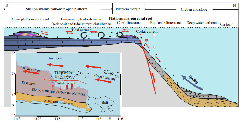
After many years of exploration and extensive coverage of seismic data in the study area, we have a more comprehensive understanding of regional geology, particularly regarding the discovery of the J reef, which we determined was located on the margin of the flat platform north of the B reef. We came to a conclusion that the J reef belongs to the platform margin reef and was controlled by the E-W trend of normal faults during its growth stage (Fig. 12). Meanwhile, the asymmetrical dome shape of the J reef corresponded to a paleo-environmental setting with a gentle side to the north and a steep side to the south. It is widely known that the modern Indonesian throughflow extends from the Pacific Ocean to the Indian Ocean through the Java Sea, which branches into the study area due to the influence of seabed topography (Gordon et al., 2003; Shinoda et al., 2012). We inferred that the branch coastal current parallel to the southern Sunda arc and the tidal current both might impact growing reefs located on the platform in the study area. Consequently, the J coral reef on the gentle platform of the south grew and developed better than that on the steep slope of the north. Specifically, we suppose that once the J reef to the south with the steep side met good hydrodynamic conditions, poor conditions to the north with a gentle side broke. However, the north side of J reef was compressed and broke intensely by the later reversed faults, which causes the north side is steeper than the south side. We infer that the J coral reefs must belong to the type reefs with strong anti-wave abilities based on the description of the cutting sample from well J-1 at a depth with Kujung limestone, which has microcrystalline properties that are firm and predominantly hard with a tight porosity. This properly corresponded to the abovementioned high-energy shallow marine carbonate platform margin. From our perspective, the southern continuous magmatic activity might be the reason for the uplift and formation of the southern platform in the MSB.
|
| Fig.12 The growth and development model of the open platform reef and the platform margin reef in the study area Red circles with a cross represent coastal currents, and the red arrows represent the tidal current. All the Kujung carbonate reefs developed to the south of the E-W trend for normal faults on the shallow marine platform. Bali Island, Madura Island and other adjacent small islands (black dotted lines in the small illustration) were shallow marine platforms. Additionally, except for the Southern Mountains arc, most of the other places in East Java were characterized by marine environments in Late Oligocene to Early Miocene. |
The sedimentary depocenter in the northern part of the study area was chiefly controlled by the E-W synsedimentary faults during the extension stage. We suppose that the sedimentary center possibly extended northward to the edge of the North Madura platform during the Paleogene. However, the study area experienced a regional structure inversion along the E-W faults from the Middle Miocene until now. The original sedimentary depocenter were uplifted, and the original highs became the new lows. In addition, the study area developed a thick deeper marine sequence, with a depositional environments ranging from middle neritic to upper bathyal in the Middle to Late Miocene. Samples of the K-1 well from the Ngrayong and Wonocolo core segments contained common to abundant and relatively diverse plankton (i.e., foraminifera and deep-water benthonic taxa such as Bolivina, Bulimina, and Hoeglundina).
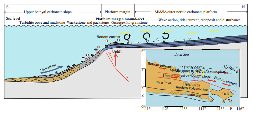
The position and environment of the O mound-reef are shown in Fig. 13. Some ideas for the formation of the Mundu Globigerinae grainstone were summarized by Triyana et al. (2007). He stated that most researchers generally considered that the northern inversion structure changed into the middle-outer neritic in the Early Pliocene (approximately 50–200 m water depth). In addition, the water depth south of the O mound-reef gradually transitioned into upper bathyal (approximately 200–500 m). However, some researchers have different views on the formation and evolution of Globigerinae grainstone reefs: Schiller et al. (1994) thought that the Mundu Formation was a series of contourite 'shore drift objects' controlled by persistent currents and different waterpower; and Ni et al.(2016) maintained that the Mundu Globigerinae grainstone was controlled by bottom currents. Considering the large number of Globigerinae that accumulated on the southern edge of the high inversion structure and the lithofacies that changed from grainstone to packstone and wackestone along the high inversion structure and the carbonate slope, we inferred that the 'hidden' inverted structure was the primary reason for the formation of mound-reefs. What's more, the South China Sea branch current, which has been regarded as an important branch of Indonesian throughflow, flows to the Java Sea from west to east through Karimata Strait (Fang et al., 2010; Du and Fang, 2011). And some data indicated that the paleocurrent flew from west to east in Early Pilocene (Ni et al., 2016). Consequently, we infer that the bottom current, wave action and tidal current played an accelerated role in the sorting and redeposition of the accumulation and evolution of grainstone reefs. In contrast with the J reef, which was located on the edge of the platform and controlled by original normal faults, the O mound-reef was influenced by the inversion faults, which did not break through the overlying Mundu strata. The water depth was divided into shallow water and relatively deep water by the O mound-reef. We identified thick middle strata thinning on both sides of the backreef zone, which may be lagoon facies restricted by the O mound-reef and the inversion structure. In addition, we inferred that the slope of progradational reflection identified from the cross O mound-reef seismic profiles might be a platform foreslope facies. We certainly assumed that it contained carbonate clastic particles, reef debris and several other algae, which mostly came from high platforms and the O mound-reef. Then, the O mound-reef stopped accumulating under poor conditions, because of the further uplift and inversion, and was finally buried by later sediments.
|
| Fig.13 The growth and evolution model for platform margin reefs in the study area, where the reef is controlled by the inversion structure but does not penetrate the upper sequence Red circles with a cross represent bottom current, and the red arrows represent the E-W trend. In addition, the yellow arrows represent the wave action and the tidal current in the middle-outer neritic. |
The abovementioned growth and evolution models for the Kujung coral reefs and the Mundu Globigerina mound-reefs are based on modern classical theory researches of reefs formation (Bubb and Hatlelid, 1978; Fontaine et al., 1987; Gu et al., 2009; Jin et al., 2013; Yang et al., 2016). And the inferred coastal current and bottom current in the models accord with the modern Indonesian throughflow, the South China Sea branch current and referenced data of paleocurrent. The upwelling and the tidal current have an effect on the fore-reef slope and back-reef platform differently. Based on the above analysis, the paleo-hydrodynamics model is reasonable and reliable.
6.3 Importance for hydrocarbon explorationAccording to the previous narrative, we have described and analysed two main reef types in the study area: platform margin reef and open platform reef. The late Oligocene to early Miocene reefs that were mostly located to the south of the E-W original normal faults were deeper carbonate reservoir rooks, and the early Pliocene reefs that were mainly located on the southern edge of the inversion structures were the second reservoir rocks. After many years of exploration and development, the late Oligocene to early Miocene reefs on the southern platform were mostly discovered and non-commercial, but the seismic data from the study area suggested that there are a number of stratigraphic and structural traps in Late Miocene-Pliocene sequences along the E-W inversion structure; these should be preserved below the thrust of the overlying strata.
7 CONCLUSIONReefs in Tertiary sequences show excellent reservoir characteristics, with high levels of porosity, permeability and saturation, which contribute to the formation of large oil and gas reservoirs in the study area.
The tectonic evolution of the Madura Strait Basin has a primary influence on the formation and evolution of two kinds of Tertiary reefs. Second, wave actions, tidal currents and other ocean currents play an accelerated role in the sorting, rounding and redeposition of the accumulation and evolution of reefs. According to the Madura Strait Basin seismic interpretation and core data, carbonate reefs are both found in the Late Oligocene to Early Miocene and Early Pliocene strata. In addition, these reefs can be divided into four types based on types, growth time, developmental position and main controlling factors: (a) open platform coral reef of the Late Oligocene to Early Miocene, (b) platform margin coral reef controlled by normal faults in Late Oligocene to Early Miocene, (c) platform margin Globigerina mound-reef controlled by the "hidden" inversion structure of the Early Pliocene, and (d) platform margin Globigerina mound-reef controlled by the thrust fault of the Early Pliocene.
Finally, we hypothesize that the formation and evolution of reefs in the study area have coral worms or marine planktons (i.e., Globigerina) that first gathered on the relatively high topography, similar to what we identify in the seismic profiles, or on the margin of the platform; then, these organisms pursued large-scale reproduction and rapid accumulation in suitable living environments, such as shallow water, relatively low-energy hydrodynamic waters, and waters with moderate temperatures and salinity. It was because of the continuous subsidence or uplift in the study area that the coral reefs and the Globigerina mound-reefs stopped accumulating under extremely adverse environments; the remnants of the skeleton structures were well buried by later sediments, which finally formed paleo-reefs in the deep underground.
8 ACKNOWLEDGEMENTThe authors wish to thank the Hangzhou Research Institute of Geology's research team and Evaluation and Detection Technology Laboratory of Marine Mineral Resources in Qingdao research team for their contributions and the approval of this publication.
Arifin M T, Ferguson A. 2017. Reservoir characterization using seismic attributes and inversion analysis of Globigerina Limestone reservoir, Madura Strait, Indonesia. In: Proceedings of the 41st Annual Convention Indonesian Petroleum Assocation. IPA, Jakarta. p.1-16.
|
Brown L F Jr, Fisher W L. 1980. Seismic stratigraphic interpretation and petroleum exploration: interpretation of depositional systems and lithofacies from seismic data.In: AAPG Continuing Education Course Note Series.AAPG, McLean, VA. p.1-125.
|
Bubb J N, Hatlelid W G. 1978. Seismic stratigraphy and global changes of sea level, part 10:seismic recognition of carbonate buildups. AAPG Bulletin, 62(5): 772-791.
|
Clements B, Hall R, Smyth H R, Cottam M A. 2009. Thrusting of a volcanic arc:a new structural model for Java. Petroleum Geoscience, 15(2): 159-174.
DOI:10.1144/1354-079309-831 |
Clements B, Hall R. 2011. A record of continental collision and regional sediment flux for the cretaceous and palaeogene core of SE Asia:implications for early Cenozoic palaeogeography. Journal of the Geological Society, 168(5): 1 187-1 200.
DOI:10.1144/0016-76492011-004 |
Du Y, Fang G H. 2011. Progress on the study of the Indonesian Seas and Indonesian throughflow. Advances in Earth Science, 26(11): 1 131-1 142.
|
Eberli G P, Masaferro J L, Sarg J F. 2004. Seismic Imaging of Carbonate Reservoirs and Systems. AAPG Memoir, 81(81): 1-9.
|
Fan X J. 2015. Control sedimentation characteristics of upper Permian Changxing formation in Yuanba area and its control action for reservoir. Journal of Southwest Petroleum University (Science & Technology Edition), 37(2): 39-48.
(in Chinese with English abstract) |
Fang G H, Susanto R D, Wirasantosa S, Qiao F L, Supangat A, Fan B, Wei Z X, Sulistiyo B, Li S J. 2010. Volume, heat, and freshwater transports from the South China Sea to Indonesian seas in the boreal winter of 2007-2008. Journal of Geophysical Research:Oceans, 115(C12): C12020.
DOI:10.1029/2010JC006225 |
Fontaine J M, Cussey R, Lacaze J, Lanaud R, Yapaudjian Y. 1987. Seismic interpretation of carbonate depositional environments. AAPG Bulletin, 71(3): 281-297.
|
Gordon A L, Susanto R D, Vranes K. 2003. Cool Indonesian throughflow as a consequence of restricted surface layer flow. Nature, 425(6960): 824-828.
DOI:10.1038/nature02038 |
Grammer G M, Ginsburg R N, Swart P K, McNeill D F, Jull A J T, Prezbindowski D R. 1993. Rapid growth rates of syndepositional marine aragonite cements in steep marginal slope deposits, Bahamas and Belize. Journal of Sedimentary Petrology, 63(5): 983-989.
|
Gu J Y, Ma F, Ji L D. 2009. Types, characteristics and main controlling factors of carbonate platform. Journal of Palaeogeography, 11(1): 21-27.
(in Chinese with English abstract) |
Hall R, Sevastjanova I. 2012. Australian crust in Indonesia. Australian Journal of Earth Sciences, 59(6): 827-844.
DOI:10.1080/08120099.2012.692335 |
Hall R. 1996. Reconstructing Cenozoic SE Asia. Geological Society, London, Special Publications, 106(1): 153-184.
DOI:10.1144/GSL.SP.1996.106.01.11 |
Hall R. 1997. Cenozoic plate tectonic reconstructions of SE Asia. Geological Society, London, Special Publications, 126(1): 11-23.
DOI:10.1144/GSL.SP.1997.126.01.03 |
Hall R. 2002. Cenozoic geological and plate tectonic evolution of SE Asia and the SW Pacific:computer-based reconstructions, model and animations. Journal of Asian Earth Sciences, 20(4): 353-431.
DOI:10.1016/S1367-9120(01)00069-4 |
Hall R. 2012. Late Jurassic-Cenozoic reconstructions of the Indonesian region and the Indian Ocean. Tectonophysics, 570-571: 1-41.
DOI:10.1016/j.tecto.2012.04.021 |
Hamilton W. 1979. Tectonics of the Indonesian Region. United States Government Printing Office, Washington, USA.
|
Handford C R, Loucks R G. 1993. Carbonate Depositional Sequences and Systems Tracts——Responses of Carbonate Platforms to Relative Sea-Level Changes:Chapter 1. AAPG Special Volumes, 168: 3-41.
|
Jin Z K, Shi L, Gao B S, Yu K H. 2013. Carbonate facies and facies models. Acta Sedimentologica Sinica, 31(6): 965-979.
(in Chinese with English abstract) |
Kopp H, Flueh E R, Petersen C J, Weinrebe W, Wittwer A, Scientists M. 2006. The Java margin revisited:evidence for subduction erosion off Java. Earth and Planetary Science Letters, 242(1-2): 130-142.
DOI:10.1016/j.epsl.2005.11.036 |
Kusumastuti A, Van Rensbergen P, Warren J K. 2002. Seismic sequence analysis and reservoir potential of drowned Miocene carbonate platforms in the Madura Strait, East Java, Indonesia. AAPG Bulletin, 86(2): 213-232.
|
Li Q F, Miao S D, Jiang Q C, Wang T S, Xu A N, Zhai X F. 2015. Sedimentary characteristics and reef-forming model of Changxing Formation in Panlongdong Section of Xuanhan, Sichuan. Journal of Jilin University (Earth Science Edition), 45(5): 1 322-1 331.
(in Chinese with English abstract) |
Longley I M. 1997. The tectonostratigraphic evolution of SE Asia. Geological Society, London, Special Publications, 126(1): 311-339.
DOI:10.1144/GSL.SP.1997.126.01.19 |
Matthews S J, Bransden P J E. 1995. Late Cretaceous and Cenozoic tectono-stratigraphic development of the East Java Sea basin, Indonesia. Marine and Petroleum Geology, 12(5): 499-510.
DOI:10.1016/0264-8172(95)91505-J |
Nayoan G A S, Arpandi, Siregar M. 1981. Tertiary carbonate reservoirs in Indonesia. In: Energy Resources of the Pacific Region. AAPG, McLean, VA. p.133-145.
|
Ni J E, Sun L C, He J, Jiang B Z, Wang H Q, Wang L, Guo L N. 2016. Characteristics of globigerinid limestone reservoirs of bottom current deposition in Gas Field A of Madura Strait, Indonesia. Oil & Gas Geology, 37(5): 773-778.
(in Chinese with English abstract) |
Read J F. 1985. Carbonate platform facies models. AAPG Bulletin, 69(1): 1-21.
|
Rutley D W. 2001. Quantitative seismic reservoir characterisation:A model-based approach for the Sampang PSC, East Java, Indonesia. Exploration Geophysics, 32(3-4): 275-278.
|
Satyana A H. 2002. Oligo-Miocene reefs: east Java's giant fields. In: Sidi F H, Setiawan A eds. Proceedings of Giant Field and New exploration concepts seminar. Indonesian Association of Geologists (IAGI), Jakarta. p.45-62.
|
Satyana A H. 2005. Oligo-Miocene carbonates of Java, Indonesia: tectono-volcanic setting and petroleum implications. Proceedings of the 30th Annual Convention.Indonesian Petroleum Association (IPA), Jakarta. 1: 217-249.
|
Schiller D M, Seubert B W, Musliki S, Abdullah M. 1994. The reservoir potential of globigerinid sands in Indonesia.Proceedings of the 23rd Annual Convention. AAPG, McLean, VA. 1: 189-212. http://archives.datapages.com/data/ipa/data/023/023001/189_ipa023a0189.htm
|
Sevastjanova I, Clements B, Hall R, Belousova E A, Griffin W L, Pearson N. 2011. Granitic magmatism, basement ages, and provenance indicators in the Malay Peninsula:insights from detrital zircon U-Pb and Hf-isotope data. Gondwana Research, 19(4): 1 024-1 039.
DOI:10.1016/j.gr.2010.10.010 |
Sharaf E, Simo J A, Carroll A R, Shields M. 2005. Stratigraphic evolution of Oligocene-Miocene carbonates and siliciclastics, East Java Basin, Indonesia. AAPG Bulletin, 89(6): 799-819.
DOI:10.1306/01040504054 |
Shinoda T, Han W Q, Metzger E J, Hurlburt H E. 2012. Seasonal variation of the Indonesian throughflow in Makassar Strait. Journal of Physical Oceanography, 42(7): 1 099-1 123.
DOI:10.1175/JPO-D-11-0120.1 |
Simandjuntak T O, Barber A J. 1996. Contrasting tectonic styles in the Neogene orogenic belts of Indonesia. Geological Society, London, Special Publications, 106(1): 185-201.
DOI:10.1144/GSL.SP.1996.106.01.12 |
Smyth H R, Hamilton P J, Hall R, Kinny P D. 2007. The deep crust beneath island arcs:inherited zircons reveal a Gondwana continental fragment beneath East Java, Indonesia. Earth and Planetary Science Letters, 258(1-2): 269-282.
DOI:10.1016/j.epsl.2007.03.044 |
Tapponnier P, Peltzer G, Armijo R. 1986. On the mechanics of the collision between India and Asia. Geological Society, London, Special Publications, 19(1): 113-157.
DOI:10.1144/GSL.SP.1986.019.01.07 |
Triyana Y, Harris G I, Basden W A, Tadiar E, Sharp N C. 2007.The maleo field: an example of the Pliocene Globigerina bioclastic limestone play in the East Java Basin, Indonesia.In: Proceedings of the 31st Annual IPA Convention.Indonesian Petroleum Association, Jakarta. p.45-61. http://archives.datapages.com/data/ipa_pdf/078/078001/pdfs/IPA07-G-115.htm
|
Vail P R, Mitchum R M Jr, Thompson Ⅲ S. 1977. Seismic stratigraphy and global changes of sea level: part 3.Relative changes of sea level from coastal onlap: section 2. Application of seismic reflection configuration to stratigrapic interpretation. In: Seismic Stratigraphy-Applications to Hydrocarbon Exploration. AAPG, McLean, VA. p.63-81.
|
Wei P S, Liu Q X, Zhang J L, Chen Q L, Zhang H Q. 2006. Re-discussion of relationship between reef and giant oilgas fields. Acta Petrolei Sinica, 27(2): 38-42.
(in Chinese with English abstract) |
Wilson J L. 1975. The stratigraphy of carbonate deposits. In: Wilson J L ed. Carbonate Facies in Geologic History.Springer, New York. p.20-55. https://link.springer.com/chapter/10.1007%2F978-1-4612-6383-8_2
|
Wilson M E J. 2002. Cenozoic carbonates in Southeast Asia:implications for equatorial carbonate development. Sedimentary Geology, 147(3-4): 295-428.
DOI:10.1016/S0037-0738(01)00228-7 |
Wu S G, Yuan S Q, Zhang G C, Ma Y B, Mi L J, Xu N. 2009. Seismic characteristics of a reef carbonate reservoir and implications for hydrocarbon exploration in deepwater of the Qiongdongnan Basin, northern South China Sea. Marine and Petroleum Geology, 26(6): 817-823.
DOI:10.1016/j.marpetgeo.2008.04.008 |
Xu H, Sun J, Liao J, Dong G, Liu J Q, Song H Y. 2012. Bioherm petroleum reservoir types and features in main sedimentary basins of the South China Sea. Journal of Earth Science, 23(6): 828-841.
DOI:10.1007/s12583-012-0293-y |
Yang F Z, Luo L, Jia D, Zhu H Q, Wu L, Li X. 2011. Cenozoic tectonic evolution of the East Java Basin, Indonesia. Geological Journal of China Universities, 17(2): 240-248.
(in Chinese with English abstract) |
Yang Z, Zhang G X, Zhang L, Wu S G, Zhu Y H, Qiang K S, Yan W. 2017a. The Spatial and Temporal Distributions of Miocene Carbonate Platform in Xisha Sea Area and Its Reservoir Model. Acta Geologica Sinica, 91(6): 1 360-1 373.
(in Chinese with English abstract) |
Yang Z, Zhang G X, Zhang L, Yan W, Lin Z, Luo S B, Qian X. 2017b. The style and hydrocarbon prospects of reefs in the Beikang Basin, southern South China Sea. Geology in China, 44(3): 428-438.
(in Chinese with English abstract) |
Yang Z, Zhang G X, Zhang L. 2016. The evolution and main controlling factors of reef and carbonate platform in Wan'an Basin. Earth Science, 41(8): 1 349-1 360.
(in Chinese with English abstract) |
Yu K F, Zhao J X, Collerson K D, Shi Q, Chen T G, Wang P X, Liu T S. 2004. Storm cycles in the last millennium recorded in Yongshu Reef, southern South China Sea. Palaeogeography, Palaeoclimatology, Palaeoecology, 210(1): 89-100.
DOI:10.1016/j.palaeo.2004.04.002 |
Zhu D C, Pan G T, Mo X X, Duan L P, Liao Z L. 2004. The age of collision between India and Eurasia. Advance in Earth Sciences, 19(4): 564-571.
(in Chinese with English abstract) |
Zhu W L, Wang Z F, Mi L J, Du X B, Xie X N, Lu Y C, Zhang D J, Sun Z P, Liu X Y, You L. 2015. Sequence stratigraphic framework and reef growth unit of Well Xike-1 from Xisha Islands, South China Sea. Earth Science-Journal of China University of Geosciences, 40(4): 677-687.
(in Chinese with English abstract) DOI:10.3799/dqkx.2015.055 |
Zou C N, Zhai G M, Zhang G Y, Wang H J, Zhang G S, Li J Z, Wang Z M, Wen Z X, Ma F, Liang Y B, Yang Z, Li X, Liang K. 2015. Formation, distribution, potential and prediction of global conventional and unconventional hydrocarbon resources. Petroleum Exploration and Development, 42(1): 14-28.
DOI:10.1016/S1876-3804(15)60002-7 |
 2019, Vol. 37


