 2020, Vol. 38
Institute of Oceanology, Chinese Academy of Sciences
Article Information
- LIU Xuehai, LIU Yongzhi, CAO Wei, SUN Chengjun
- Water characteristics of abyssal and hadal zones in the southern Yap Trench observed with the submersible Jiaolong
- Journal of Oceanology and Limnology, 38(3): 593-605
- http://dx.doi.org/10.1007/s00343-019-8368-6
Article History
- Received Dec. 27, 2018
- accepted in principle Feb. 20, 2019
- accepted for publication Jun. 10, 2019


2 Laboratory for Regional Oceanography and Numerical Modeling, Pilot National Laboratory for Marine Science and Technology(Qingdao), Qingdao 266237, China;
3 Key Laboratory of Marine Science and Numerical Modeling, Ministry of Natural Resources, Qingdao 266061, China
The Yap Trench is an important segment of the arcuate trench system in the Northwest Pacific, linking the waters in Mariana-Caroline basins (Kaneko et al., 1998). The length of the trench is ~700 km with a maximum depth ~8 527 m (Fujioka et al., 2000). Previous studies mainly focused on morphology and tectonics of the trench (Fujioka et al., 2000; Kobayashi, 2004), and so far, the hydrodynamic observation and studies are rare.
Johnson and Toole (1993) and Kawabe and Taira (1998) proposed that there are three types of deep watermass in the Northwest Pacific. The bottom salty and oxygen-rich water is referred to as Lower Circumpolar Water (LCPW); the water lying above LCPW is referred to as North Pacific Deep Water (NPDW); and the water marked by a minimum salinity above the NPDW is Antarctic Intermediate Water. Usually the water exceeding 3 000 m is defined as abyssal water (Macdonald et al., 2009; Hautala, 2018). The abyssal water in Mariana-Caroline regions is from LCPW, with the inflow of LCPW into the East Mariana Basin (EMB) and a partial outflow to the West Mariana Basin (Uehara and Taira, 1990; Johnson and Toole, 1993; Yanagimoto and Kawabe, 2007; Huang et al., 2018). Siedler et al. (2004) found that the channels at the Yap-Mariana Junction and Caroline Ridge were essential for the exchange of deep water such as water flowing to East Caroline Basin (ECB) from EMB. Using observations by the submersible Jiaolong system, Liu et al. (2018) studied the watermass properties and deep currents in the northern Yap Trench, and suggested that the deep water originates from EMB and ECB as a part of the west propagating LCPW. However, the deep circulation and water properties in the southern Yap Trench remain unrevealed. Besides, the understanding in the hadal zone, which is below 6 000 m, is absent.
The water linkage between the southern Yap Trench and the northern part is obstructed by a sill at a depth of ~5 000 m (as shown in Fig. 1). Consequently, the properties of abyssal and hadal water in the two parts maybe have some differences. This means the local characteristics exists in the southern Yap Trench. Because the southern trench connects the Caroline Basin, the hydrodynamic investigation in the trench is helpful for identification of the water transportation and deep circulation in Mariana-Caroline regions. Additionally, the investigation addressed here is also important for understanding the local biologicalchemical processes and material exchange with adjacent basins and trenches.

|
| Fig.1 Bathymetry and observation stations of the No. 38 Cruise a. the bathymetry of the Yap Trench and adjacent areas. SYT: the southern Yap Trench; NYT: the northern Yap Trench; MT: Mariana Trench; CB: Caroline Basin; MB: Mariana Basin; PB: Philippine Basin. The rectangle indicates the cruise area in SYT; b. the local bathymetry and the cruise area in SYT. C01–C04: the stations observed with ship-based CTD. Jiaolong dives at D148–D152. Section-C and Section-D are transects along two kinds of observation stations. |
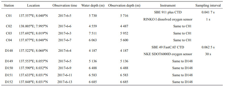
We conducted the investigation in the northern Yap Trench mainly by the submersible Jiaolong in No. 37 of Chinese Ocean Cruises (Liu et al., 2018). As the first deep-sea manned submersible in China (Liu et al., 2010), Jiaolong has made hundreds of deep dives (maximum down to 7 062 m in Mariana Trench in 2012) in the South China Sea, Pacific, and Indian Ocean for multidisciplinary explorations (Li, 2017). Jiaolong and its mother ship equip tens of instruments including the conductivity-temperature-depth profiler (CTD). The information of instruments used in this study is listed in Table 1.
|
In this paper, using the observations in an applied cruise of the submersible Jiaolong (No. 38 of Chinese Ocean Cruises), we aim to study the water characteristics, geostrophic flow and turbulent mixing of abyssal and hadal zones in the southern Yap Trench. The paper is organized as follows. The data and methods used are described in Section 2. Section 3 displays the results and the analysis of water characteristics, geostrophic flow and turbulent mixing. A brief discussion and conclusion are presented in Section 4 and Section 5, respectively.
2 DATA AND METHOD 2.1 The study regionThe Yap Trench is separated into the northern and southern parts by a sill at 9°N at the depth of around 5 000 m (Fig. 1). The southern part forms an important segment of an arc trench system in the Western Pacific. The maximum depth reaches 8 527 m in the central basin according to the topography from the General Bathymetric Chart of the Oceans (GEBCO_2014). This topography dataset has a resolution of 30 arc-second interval grid, access from the web (http://www.gebco.net/data_and_products/gridded_bathymetry_data/). Across the trench at around 8°N, the study area is located in the middle of the southern Yap Trench and in the southern margin of the Philippine Sea Plate.
In this paper, only abyssal and hadal water is studied. The range for an abyss is 3 000–6 000 m, and below that, the hadal zone is defined.
2.2 Observations and data processingThe No. 38 Cruise was conducted in the southern Yap Trench from June 3 to June 14, 2017, which is an applied oceanic scientific expedition of the deep-sea manned submersible Jiaolong with the R/V Xiangyanghong 09 as its mother ship, lead by China Ocean Mineral Resources R & D Association and financially supported by the National Key Basic Research Program of China.
As shown in Fig. 1b, nine observation sites were deployed across the abyssal trench along slope in a zonal direction overall. Among them, four casts (C01, C02, C03, and C04) were conducted using mainly ship-based CTD and dissolved oxygen sensors, and five dives of Jiaolong (D148, D149, D150, D151, and D152) were observed using a set of CTD and dissolved oxygen sensor to obtain vertical profiles of temperature, salinity, and dissolved oxygen. Table 1 shows the information of the instruments, geographical positions, observation periods, and casting or diving depths. The maximum depth was 4 487–5 952 m for ship-based CTD observation and 4 187–6 685 m for Jiaolong dives, and all dives reached the sea bottom. C01, D148, D149, D150, and D151 were located in the west slope of the trench, C03 was in the central region, and C04, C04, and D152 were at the east slope. Situated in the flank of the trench, D148 and C02 had the shallowest bottom and observation depths.
The observation data were reprocessed with SBE (Sea-Bird equipment) Data Processing Software V7.2 to obtain the values of temperature, salinity, density, and concentration of dissolved oxygen in a 1-m interval depth grid by the cubic spline interpolation in vertical after manually eliminating abnormal values. Only the data during lowering process are used in the study. The accuracy of SBE 911 Plus CTD is 0.001℃ for temperature and 0.000 3 S/m for conductivity, and that of SBE 16 Plus CTD is 0.005℃ for temperature and 0.000 5 S/m for conductivity. The equation of state is Thermodynamic Equation of Seawater 2010 (TEOS-10), which is implemented with Gibbs Sea Water (GSW) Oceanographic Toolbox (GSW, http://www.teos-10.org/).
2.3 Computation of geostrophic flowsThe meridional geostrophic flows at transects of Section-C and Section-D were computed from observed CTD data using the thermal wind relation:
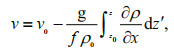 (1)
(1)where v and v0 are geostrophic velocities at the depth z and at the reference level z0, respectively; g is the gravitational acceleration; f is the Coriolis parameter; ρ and ρ0 is the potential density and characteristic potential density, respectively.
In this paper, the reference level is 3 000 m according to previous abyssal studies and adjacent trenches and basins (Johnson and Toole, 1993; Taira et al., 2005; Huang et al., 2018; Liu et al., 2018). At this weak circulation level, the meridional geostrophic velocity across transects Section-C and Section-D is set to be zero, hence we treated the calculated flows relative to the level as the geostrophic flows at abyssal and hadal depths. The geostrophic flow and volume transport were estimated from the observations by Jiaolong-carried CTD and ship-based CTD, respectively.
2.4 Computation of diapycnal mixingTurbulent diapycnal mixing were computed using the Thorpe method (Thorpe, 1977) from CTD data. The turbulence dissipation rate ε and the vertical diapycnal diffusivity K are formulated by:
 (2)
(2) (3)
(3)where the ratio of the Ozmidov scale to the Thorpe overturn scale c =0.8 (Dillon, 1982), the mixing efficiency m =0.2 (Osborn, 1980); N is the buoyancy frequency obtained from CTD data (Klymak et al., 2008); d is the Thorpe scale which is defined as the root-mean-square of all displacements between the real depth for a measured density and the depths in a reordered steady density profile within a complete overturn. The overturn is detected by comparing the original and sorted density profiles. Here, the tests are implemented using the method of a previous study (Yang et al., 2016) to remove the spurious overturns.
The average dissipation rate ε and diapycnal diffusivity K over a depth range H are as follows:
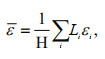 (4)
(4)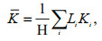 (5)
(5)where Li, εi, and Ki are the depth range, dissipation rate and diapycnal diffusivity of the i-th overturn within the range H, respectively. Here, H is set to be 300 m. The above turbulent mixing values are computed from 3 000 m to the maximum CTD casting or diving depths of nine stations.
3 RESULT AND ANALYSIS 3.1 Structure of abyssal water observed by shipbased CTDFigure 2 shows the vertical profiles of temperature and potential temperature θ3 (referred to 3 000 dbar), salinity, potential density σ3 (potential density referred to 3 000 dbar) and dissolved oxygen in the abyssal zone of the trench between 3 000 m and 6 000 m observed by ship-based instruments.

|
| Fig.2 Vertical profiles below 3 000 m at stations C01–C04 observed with ship-based instruments a. temperature and potential temperature θ3 referred to 3 000 dbar; b. salinity; c. potential density σ3 referred to 3 000 dbar (potential density minus 1 000 kg/m3); d. concentration of dissolved oxygen (1 mL/L=22.4/32 mg/L). |
The temperature gradually decreases to the minimum values 1.453–1.463℃ at around 4 500 m from 1.576–1.595℃, and then continually increases with depth due to adiabatic pressure. The maximum temperature is observed as 1.572℃ at 5 716 m of C01, 1.607℃ at 5 952 m of C03, and 1.558℃ at 5 600 m of C04. Obviously, at the critical depth from the abyss to the hadal zone, the temperature surpasses that at 3 000 m. In a layer of 3 000–3 300 m, the order of the mean temperatures is C01 > C04 > C03 > C02. From 3 500 to 4 300 m, the overall order turns to be C02 > C04 > C03 > C01. This indicates that in the top 1 300 m abyssal water, the temperature on the west trench slope decreases more than that on the east slope. In the ~150 m layer below ~4 500 m where temperature steadily keeps the minimum temperature, C01, on a steeper slope, has the highest temperature, and C03, near the central of the trench, is the coolest. This suggests that the temperature over the central trench is depressed more than that at the flank. This is similar to the phenomena in the Challenger Deep of the Mariana Trench (Huang et al., 2018). At lower depths, temperature increases to the almost same in the three stations. On the other hand, the comparison for depths with the same temperature shows that C02 has the shallowest level for isotherm in the upper ~300 m layer but the deepest below the layer. From ~4 500 m to ~5 300 m, the isotherm level is shallower at C01 and deeper at C04.
The potential temperature decreases continually with depth (Fig. 2a). At the reference level, θ3 is 1.572–1.599℃. The minimum is 1.243℃, appearing in the lowest layer of abyss at C03. The cooling is obvious in the top 1 500 m and very small in the next ~1 000 m. Below 5 500 m, temperature is steady. Similar to the real temperature, potential temperature varies differently at four stations. The profiles show that from 3 000 m to 4 500 m, potential temperature decreases less at a flank station C02 and more at a central station C03, which is same as the aforementioned for real temperature. In the top 300 m layer, C02 is colder than other stations. However, C01 is the coolest in the next 1 000 m where the slope is steep. Below 4 500 m, the potential temperature at C03 varies less than that at the flank stations. The pattern of the isotherm level for potential temperature is the same to that for the real temperature.
The profiles of salinity present a similar pattern to those of potential temperature (Fig. 2a & b). From the reference level to the maximum depth, salinity continually increases to 34.682 at more than ~5 500 m from 34.655–34.657. There is an obviously increase in the top ~1 600 m and a slight rise for deeper water. In addition, C02 is more saline than those of other stations at 3 000–3 400 m but evolves into less saline in the next ~1 000 m layer, in which C01 is more saline. This means that the isohaline at C02 is shallower in the first 400 m and deeper in the layer from 400 m to 1 400 m than other stations, and in this layer C01 has shallower isohaline. Generally, the central station C03 is less saline at the isobar levels in abyss.
Potential density has the similar patterns to those of salinity and potential temperature both in vertical and in horizontal. At 3 000 m, the density σ3 is 41.441–41.447 kg/m3, and then increases to 41.510 kg/m3 at ~4 700 m. Below the depth, the increase is very small (0.003 kg/m3 totally). At the isobar levels in the upper 300 m, C02 is denser than other stations. Between 3 600 m and 4 300 m, the density is highest at C01 and least at C02. Below 4 700 m, C04 has higher densities and C03 has lower. From an isopycnal perspective, C02 is shallower for a density less than 41.459 kg/m3, but its isopycnal is deeper for the potential density exceeding 41.468 kg/m3. Overall, C3 has the relatively deep isopycnal. This means that the isopycnal of abyssal water is depressed in the central region of the trench.
The content of dissolved oxygen increases with depth. In the upper 1 600 m, the continuous increase is apparent (from ~2.90 mL/L to ~3.41 mL/L). It is indicated from Fig. 2a–d that the saline, cold, and dense water is rich in oxygen. Therefore, the pattern for profiles of oxygen is consistent with those of salinity, potential density, and potential temperature (oxygen-rich corresponding to cold). As shown in Fig. 2d, C02 has more oxygen than other stations between 3 000–3 400 m but less content in the next ~1 000 m layer, in which C01 is relatively rich in oxygen. In addition, below ~4 800 m, the oxygen content decreases obviously with the depth increase at the stations.
In summary, the conventional CTD observation displays the abyssal water characteristics for different regions across the trench, and the spatial patterns are consistent for temperature, salinity, density, and oxygen content. Their spatial structures are directly related to geostrophic flow and turbulent mixing, which are investigated in following sections.
3.2 Water characteristics in abyssal and hadal zones observed by JiaolongFigure 3 presents the profiles of potential temperature θ3, salinity, potential density σ3 and dissolved oxygen at abyssal and hadal depths in the trench observed by Jiaolong instruments.

|
| Fig.3 Vertical profiles below 3 000 m along Section-D observed by Jiaolong-carried instruments a. potential temperature θ3 referred to 3 000 dbar; b. salinity; c. potential density σ3 referred to 3 000 dbar (potential density minus 1 000 kg/m3); d. concentration of dissolved oxygen. In the panels, dash lines indicate locations and depths of dives. |
Above 5 500 m, four elements have the similar variation with depth. Potential temperatures decrease monotonously and the others increase continually. This means the deeper water is more saline, colder, denser, and oxygen-richer. The vertical changes are marked between 3 000–4 500 m, which is consistent with the observed by ship-based CTD. From ~1.60℃, θ3 decreases to 1.25℃ at ~5 300 m at D151 and ~5 000 m at D152. Below the depths, the value decreases only 0.007℃, indicating that potential temperature varies very little in hadal water and lower abyss. From 34.664 at 3 000 m, salinity increases to the maximum value 34.685 at ~5 300 m. Below the depth it keeps steady even though there is a very little drop at hadal depths. σ3 increases to ~41.515 kg/m3 at ~5 000 m from ~41.448 kg/m3, and keeps homogeneous in the hadal zone. From ~3.5 mL/L, dissolved oxygen increases to over 3.95 mL/L (with a maximum ~4.0 mL/L at the depth of ~4 800 m) below ~4 600 m, and then decrease obviously below ~5 400 m with a minimum of 3.5 mL/L.
Additionally, although there is a difference in the oxygen content between the observed by casting and that by Jiaolong using different sensors, their distribution patterns are identical. Two kinds of observations show that oxygen increases with depth, and the cold, saline, and dense water is relatively rich in oxygen. This has been observed in adjacent trenches and basins (Johnson and Toole, 1993; Kaneko et al., 1998; Kato and Kawabe, 2009; Huang et al., 2018; Liu et al., 2018). In particular, using Jiaolong-carried instruments, we observed that the oxygen is poorer in the hadal zone than that in the abyssal layer lying above the zone. This is probably related to the shortage of oxygen supplement from LCPW. Besides, the higher biomass in the near-bottom and hadal zones (Ichino et al., 2015) needs more consumption of oxygen. The observation demonstrates spatial variability. The contours of potential temperature, salinity, and potential density in Section-D are depressed over the trench between 3 000 m and ~4 200 m, in which the isotherm, isopycnal and isohaline at the western flank are shallower than those over the central trench. This was observed by shipbased CTD. Among the layers of ~4 500–5 500 m in the trench, the isolines are tilting and lift from west to east. Below 5 500 m, the difference is not obvious across the trench, so the potential temperature, salinity and potential density are uniformly distributed in the hadal zone.
In summary, the observation of submersible Jiaolong presents similar spatial pattern with ship-based CTD, reveals that the isolines of potential temperature, salinity and potential density are depressed over the central trench. In hadal zone, these elements are homogeneous, but the oxygen content decreases.
3.3 Characteristics in θ-S diagram and abyssal watermassFigure 4a & b present the θ-S scatter diagrams below the reference level observed by ship-based and Jiaolong-carried CTDs. The diagrams show that the abyssal and hadal water becomes colder and more saline with the increasing of depth, with the exception of hadal and near-hadal depths. In Fig. 4a for shipbased CTD, both of potential temperature and salinity have the very small rate of change when θ3 drops to ~1.245℃ below ~5 500 m (as shown in Fig. 2a & b). This is also observed by Jiaolong as indicated in Figs. 4b, 3a & 3b. Moreover, Fig. 4b shows that in hadal zone, potential temperature keeps homogeneous and salinity decreases a little.

|
| Fig.4 The θ-S scatter diagram with σ3 contours overlain The panes show distributions of the potential temperature θ3 referred to 3 000 dbar and salinity at different potential density layer below 3 000 m, observed by ship-based CTD (a) and Jiaolong-carried CTD (b), respectively. |
The relation of potential temperature versus salinity with potential density contours overlain shows the spatial difference between stations zonally across the trench. For the fact that a lower potential temperature corresponds to a higher salinity for abyssal water, the difference of the relation at different stations is not distinct in the diagrams. Even so, some small difference enlarges the spatial disparity in isopycnal. For the ship-based observation, at the same θ3 between ~1.59℃ and ~1.47℃, the salinity at C04 is highest, resulting in denser water and shallower isopycnal. In general, the central station C03 has a relatively low salinity at a same temperature, consequently lowering the density and deepening the isopycnal. For observations of Jiaolong (Fig. 4b), at the same depth, the water at D148 is relatively cold and saline, and D150 has higher temperature and lower salinity. This indicates that above 4 200 m, the isopycnal is shallower at the flank than in the central trench.
3.4 Geostrophic flows and water transportFigure 5a shows the meridional geostrophic flows at Section-C estimated from temperature and salinity observed by ship-based CTD. From C01 to C04, the flows basically travel southward except for the upper ~1 800 m layer (C01–C03) in which there is weak northward flow (< 1 cm/s). Between ~4 000 m and ~5 000 m, the southward flows are relatively strong (in 2–3 cm/s). From C04 to C02, the east flank of the trench shows northward flows with a maximum velocity of 3.3 cm/s.

|
| Fig.5 Meridional geostrophic flows relative to the reference level in abyss crossing transects a. along Section-C calculated from observations of ship-based CTD; b. along Section-D calculated from observations of Jiaolong. Positive and negative values correspond to northward and southward currents, respectively. CTD casts and Jiaolong dives are indicated by dash lines. |
Figure 5b presents the flows along Section-D estimated from observations of Jiaolong. At the west flank, the flows travel southward in the whole abyssal column. In the bottom layer at D149 on the steep slope, the velocity is the highest (with a maximum of 13.5 cm/s). From a west station D150 to D152 on the east slope, the southward flows gradually become to be in an opposite direction. Above ~3 700 m, the east of ~137.6°E shows a weak northward flow. Between ~3 700–4 700 m, the flows become northward at ~137.8°E. Below the layer, the flows are basically southward in the west of ~137.8°E and northward in the east with a maximum speed of 2.5 cm/s at depths close to the hadal zone.
Both contours show that the meridional geostrophic flows are southward in the west and northward in the east. This opposing pattern suggests the cyclonic circulation in abyss. With consideration of the spatial difference between D148–D149 and C01, the strong flows occurred on the west slope according to Jiaolong's observations, while this pattern was not presented in Section-C. Jiaolong can observe in deeper water than the conventional method to obtain hadal flows, but it has no observation in the central area, resulting in a certain discrepancy in estimated flows between two methods. Nevertheless, they show a similar pattern for the flows.
With the results shown in Fig. 5, we estimated the geostrophic transports from the reference level to abyssal depths at Section-C and Section-D (Fig. 6a). Along section-C, the net volume in northward keeps increasing with depth and reaches the maximum of ~0.26 Sv at ~4 000 m. The volume reaches zero at ~4 500 m and increases to ~0.8 Sv (the positive means southward) at the maximum observation depth ~5 950 m. At Section-D, the net transport keeps close to zero in the first 500 m and then continually increases to ~1.74 Sv at 6 000 m. In hadal zone, the transport reaches the maximum ~1.77 Sv at ~6 500 m and then decreases slightly to ~1.75 Sv at the maximum diving depth of 6 685 m.

|
| Fig.6 Meridional geostrophic transports across transects estimated between 3 000 m and abyssal depths a. the volume transports at Section-C observed by ship-based CTD and at Section-D observed by Jiaolong; b. the transport at the transect D149–D152 estimated from Jiaolong CTD and the transport between C01 and D152 observed by ship-based CTD. The northward is positive. |
For the difference in width and locations between two sections, their variations in the net transport are similar but somewhat different. We computed the transport along two close transects: D149–D152 for Jiaolong and C01–D152 for ship-based CTD (Fig. 6b). The panel shows two identical profiles of transport volumes. In the central part across the trench, the net transport is close to zero at the layer above 3 500 m, and below the level, it keeps increasing with depth. In the hadal zone, the southward transport is balanced by the northward.
In summary, the meridional geostrophic flows in abyssal and hadal zones are southward in the western part of the southern Yap Trench and opposite in the eastern. In the main region of the trench, the net transport of abyssal water is southward. The net transport of the hadal water decreases to zero.
3.5 Diapycnal mixingThe estimated dissipation rate and eddy diffusivity of abyssal water at C01–C04 and D148–D152 are shown in Figs. 7 & 8. The magnitude of dissipation rate and diffusivity is ε~O (10-8–10-6 W/kg) and K~O (10-3–10-1 m2/s), respectively.

|
| Fig.7 Profiles of average dissipation rate ε over a depth range H =300 m a. computed from observations by ship-based CTD at the four stations; b. computed from observations of Jiaolong-carried CTD at the five stations. |

|
| Fig.8 Profiles of average diapycnal diffusivity K over a depth range H =300 m a. computed from observations by ship-based CTD at the four stations; b. computed from observations of Jiaolong-carried CTD at the five stations. |
At the stations of ship-based observation, the average dissipation rate is almost constant in the upper ~1 400 m layer. Below 4 100 m, the average dissipation increases with depth. At the deepest water, the rate reaches ~7.8×10⁻⁸ W/kg. C03 has the highest dissipation rate above 4 700 m except for ~4 100–4 400 m. The diapycnal diffusivity presents the similar pattern to the dissipation rate. The average diffusivity increases a little in the first ~700 m. After a slight decrease, the diffusivity strengthens continually from 3 700 m to 5 900 m and reaches the maximum of ~1.1×10⁻²m2/s. Generally, the water on the steep slope and the deeper abyssal water in the central trench show relatively strong mixing.
At stations of Jiaolong dives, the magnitude of dissipation rate and diffusivity is same as those of C01–C04. Generally, the mean values are higher in deeper water. Above 5 200 m, both the dissipation rate and diffusivity are relatively low at D151 where the topography is flat, while those at locations on the steep slope are quite high and weaken the stratification (shown in Fig. 3). This corresponds to the depressions of isolines of potential temperature, salinity, and potential density over the central trench as shown in Fig. 3. Compared with the results at stations C01– C04, we found that the mixing is active in the hadal water on the steep slope, especially at the near-bottom zone where the geostrophic flows are strong and the gradient of potential density is weak.
In summary, the dissipation rate and diffusivity keep almost constant in the upper layer and then increase with depth. The turbulent mixing is strong on the steep slope and hadal zone where the strong geostrophic flows and small gradient of potential density exist.
4 DISCUSSION 4.1 Comparison of water properties in the southern Yap Trench with the northernThe observations reveal that in the southern Yap Trench, the water obviously becomes colder, denser, more saline more oxygen with the depth increase between 3 000 m and ~4 500 m, and below this layer, the rate of change is very small but the oxygen content decreases obviously. The vertical patterns are consistent to the observed in the northern Yap Trench (Liu et al., 2018). This indicates that two parts of Yap Trench have the same or similar properties of watermass. In addition, the isolines of temperature, salinity, and density are depressed over the central trench, and in hadal zone. This phenomenon was observed in the Challenger Deep of the Mariana Trench (Huang et al., 2018). However, different spatial patterns were shown in the north of the trench by Liu et al. (2018), where the isopycnal continually becomes deeper from the western side of the trench to the eastern side. These differences lead to the different patterns for geostrophic transport. In the southern trench, the abyssal circulation is cyclonic with the southward flows in the western area and the northward in the eastern, and the net transport is southward. While in the northern trench, the route of LCPW is northward. Additionally, the circulation in the Challenger Deep is cyclonic (Taira et al., 2004; Huang et al., 2018). Johnson (1998) reported that the cyclonic sense of circulation is often evident in trenches of the Pacific.
Comparison shows the similar pattern of diapycnal mixing in the south and north of the Yap Trench. The magnitude of dissipation rate and diffusivity in the southern trench is same to that in the north (Liu et al., 2018). In both areas, the dissipation changes little at the depth range of 3 000–4 500 m, in the deeper layer, the diapycnal mixing increases with depth, and the enhancement of mixing weakens water stratification in the deeper abyssal and hadal zone. Besides, the mixing is strong along the slopes in the two areas of the trench. The strong mixing seems to be related to the geostrophic flows and internal tide dissipation analyzed in the north trench by Liu et al. (2018). Additionally, our findings agree largely with the measurements by Huang et al. (2018) in the Challenger Deep.
4.2 The origin of the abyssal and hadal water in the Southern Yap TrenchPrevious studies proved that the deep water in trenches and basins of Mariana-Caroline regions including the northern Yap Trench is from LCPW (Siedler et al., 2004; Huang et al., 2018; Liu et al., 2018). The same characteristics of the abyssal watermass is cold, saline, and rich in oxygen, indicating that the abyssal water in the southern Yap Trench is linked to adjacent water by deep flows, which is of LCPW. Although in the past, no observation was conducted in the abyss of the southern Yap Trench, Kaneko et al. (1998) found a broad isopycnal depression and suggested that a part of the westward flow at the Mariana Basin enters the Caroline Basin via the Yap Trench based on the observation of watermass at about 7°N and other sections in the west North Pacific. Studies by Kawabe et al. (2003) and Siedler et al. (2004) also proved the connection between the Yap Trench and two basins where the deep water below NPDW is of LCPW.
On the other hand, the flow of LCPW is blocked by sills in trenches and basins, and the downwelling water is difficult to reach the depths below 6 000 m. Furthermore, the salinity and oxygen content decrease in hadal water (seen in Figs. 2d, 3c–d & 4b), so they are lower in the observed hadal zone than those of LCPW. This suggests that the hadal water in the Southern Yap Trench maybe is the isolated local water rather than LCPW. Nevertheless, based on this local observation and very few previous studies, we cannot make sure whether the hadal water in the trench is of LCPW or isolated local water.
5 CONCLUSIONBased on the observations of ship-based CTD and the manned submersible Jiaolong, we analyzed the water characteristics, geostrophic transport and turbulent mixing in abyssal and hadal zones of the southern Yap Trench. The conventional CTD observation presented the results for the depth less than 6 000 m at stations covering the trench slope and the central area, while the submersible conducted observation from the sea surface to the sea bed below 6 000 m along the slope of the hadal trench. Two kinds of observation obtained the consistent and mutually complementary results.
The similar spatial patterns for temperature, salinity, density and oxygen content are shown. The abyssal water is cold, saline and oxygen rich. In hadal zone, the potential temperature and potential density keep almost homogeneous, with a little decrease in salinity and a distinct reduction in the content of oxygen. Results show that the isolines of potential temperature, salinity and potential density are depressed over the central trench in abyss. At the steep slope where the stratification is weakened, the dissipation rate and diffusivity are relatively large. The diapycnal mixing is enhanced in the near-bottom zone and also active in the hadal water.
In abyssal and hadal zones of the southern Yap Trench, the estimated meridional geostrophic flows are southward in the western part and northward in the eastern. In the main region of the trench, the water transport is ~1.74 Sv and southward in the range of 3 000–6 000 m. Below 6 000 m, the southward transport is balanced by the northward. This suggests existence of cyclonic circulation.
The analysis of properties of watermass indicates that the abyssal water in the southern Yap Trench is of LCPW, and suggests that the hadal water seems to be of the isolated local water rather than LCPW. However, the existed studies are still not enough to verify the attribution of the watermass. Moreover, the connections and water exchanges of the southern Yap Trench to adjacent trenches and basins such as the northern Yap Trench, Caroline Basin, and Mariana Basin are to be studied with more observations, in order to reveal the origins and flow paths of the abyssal and hadal water in the trench.
6 DATA AVAILABILITY STATEMENTThe data that support the findings of this study, described in Section 2.2, are available from the National Deep Sea Center, Ministry of Natural Resources of China but restrictions apply to the availability of the data, which were used under license for the current study, and so are not publicly available. However, data are available from the first author of this paper upon reasonable request and with permission of the National Deep Sea Center, Ministry of Natural Resources of China.
7 ACKNOWLEDGMENTWe thank the crews and scientists aboard R/V Xiangyanghong 09 and the submersible Jiaolong for data acquisition and sample collections in the No. 38 of Chinese Ocean Cruises. We acknowledge the National Deep Sea Center, Ministry of Natural Resources of China for providing observation data of Jiaolong. We thank Dr. YANG Jichao, Dr. WANG Chunsheng, and Dr. LU Bo for their cooperation and helps in data sharing. We also thank the anonymous reviewers for providing valuable suggestions.
Dillon T M. 1982. Vertical overturns:a comparison of Thorpe and Ozmidov length scales. Journal of Geophysical Research, 87(C12): 9 601-9 613.
DOI:10.1029/JC087iC12p09601 |
Fujiwara T, Tamura C, Nishizawa A, Fujioka K, Kobayashi K, Iwabuchi Y. 2000. Morphology and tectonics of the Yap Trench. Marine Geophysical Research, 21(1-2): 69-86.
DOI:10.1023/A:1004781927661 |
Hautala S L. 2018. The abyssal and deep circulation of the Northeast Pacific Basin. Progress in Oceanography, 160: 68-82.
|
Huang C J, Xie Q, Wang D X, Shu Y Q, Xu H Z, Xiao J G, Zu T T, Long T, Zhang T C. 2018. Seasonal variability of water characteristics in the Challenger Deep observed by four cruises. Scientific Reports, 8: 11 791.
DOI:10.1038/s41598-018-30176-4 |
Ichino M C, Clark M R, Drazen J C, Jamieson A, Jones D O B, Martin A P, Rowden A A, Shank T M, Yancey P H, Ruhl H A. 2015. The distribution of benthic biomass in hadal trenches:A modelling approach to investigate the effect of vertical and lateral organic matter transport to the seafloor. Deep Sea Research Part Ⅰ:Oceanographic Research Papers, 100: 21-33.
DOI:10.1016/j.dsr.2015.01.010 |
Johnson G C, Toole J M. 1993. Flow of deep and bottom waters in the Pacific at 10°N. Deep Sea Research Part Ⅰ:Oceanographic Research Papers, 40(2): 371-394.
DOI:10.1016/0967-0637(93)90009-R |
Kaneko I, Takatsuki Y, Kamiya H, Kawae S. 1998. Water property and current distributions along the WHP-P9 section (137°-142°E) in the western North Pacific. Journal of Geophysical Research:Oceans, 103(C6): 12 959-12 984.
DOI:10.1029/97JC03761 |
Kato F, Kawabe M. 2009. Volume transport and distribution of deep circulation at 165°W in the North Pacific. Deep Sea Research Part Ⅰ:Oceanographic Research Papers, 56(12): 2 077-2 087.
DOI:10.1016/j.dsr.2009.08.004 |
Kawabe M, Fujio S, Yanagimoto D. 2003. Deep-water circulation at low latitudes in the western North Pacific. Deep Sea Research Part Ⅰ:Oceanographic Research Papers, 50(5): 631-656.
DOI:10.1016/S0967-0637(03)00040-2 |
Kawabe M, Taira K. 1998. Water masses and properties of 165°E in the western Pacific. Journal of Geophysical Research:Oceans, 1031(C6): 12 941-12 958.
|
Klymak J M, Pinkel R, Rainville L. 2008. Direct breaking of the internal tide near topography:Kaena Ridge, Hawaii. Journal of Physical Oceanography, 38(2): 380-399.
DOI:10.1175/2007JPO3728.1 |
Kobayashi K. 2004. Origin of the Palau and Yap trench-arc systems. Geophysical Journal International, 157(3): 1 303-1 315.
DOI:10.1111/j.1365-246X.2003.02244.x |
Li X Z. 2017. Taxonomic research on deep-sea macrofauna in the South China Sea using the Chinese deep-sea submersible Jiaolong. Integrative Zoology, 12(4): 270-282.
DOI:10.1111/1749-4877.12254 |
Liu F, Cui W C, Li X Y. 2010. China's first deep manned submersible, JIAOLONG. Science China Earth Science, 53(10): 1 407-1 410.
DOI:10.1007/s11430-010-4100-2 |
Liu Y Z, Liu X H, Lv X Q, Cao W, Sun C J, Lu J, Wang C S, Lu B, Yang J C. 2018. Watermass properties and deep currents in the northern Yap Trench observed by the Submersible Jiaolong system. Deep Sea Research Part Ⅰ:Oceanographic Research Papers, 139: 27-42.
|
Macdonald A M, Mecking S, Robbins P E, Toole J M, Johnson G C, Talley L, Cook M, Wijffels S E. 2009. The WOCEera 3-D Pacific Ocean circulation and heat budget. Progress in Oceanography, 82(4): 281-325.
DOI:10.1016/j.pocean.2009.08.002 |
Osborn T R. 1980. Estimates of the local rate of vertical diffusion from dissipation measurements. Journal of Physical Oceanography, 10(1): 83-89.
DOI:10.1175/1520-0485(1980)010<0083:EOTLRO>2.0.CO;2 |
Siedler G, Holfort J, Zenk W, Müller T J, Csernok T. 2004. Deep-water flow in the Mariana and Caroline Basins. Journal of Physical Oceanography, 34(3): 566-581.
DOI:10.1175/2511.1 |
Taira K, Kitagawa S, Yamashiro T, Yanagimoto D. 2004. Deep and bottom currents in the challenger Deep, Mariana Trench, measured with super-deep current meters. Journal of Oceanography, 60(6): 919-926.
DOI:10.1007/s10872-005-0001-y |
Taira K, Yanagimoto D, Kitagawa S. 2005. Deep CTD casts in the challenger deep, Mariana trench. Journal of Oceanography, 61(3): 447-454.
DOI:10.1007/s10872-005-0053-z |
Thorpe S A. 1977. Turbulence and mixing in a Scottish Loch. Philosophical Transactions of the Royal Society A:Mathematical, Physical and Engineering Sciences, 286(1334): 125-181.
DOI:10.1098/rsta.1977.0112 |
Uehara K, Taira K. 1990. Deep hydrographic structure along 12°N and 13°N in the Philippine Sea. Journal of the Oceanographical Society of Japan, 46(4): 167-176.
DOI:10.1007/BF02125577 |
Yanagimoto D, Kawabe M. 2007. Deep-circulation flow at mid-latitude in the western North Pacific. Deep Sea Research Part Ⅰ:Oceanographic Research Papers, 54(12): 2 067-2 081.
DOI:10.1016/j.dsr.2007.09.004 |
Yang Q X, Zhao W, Liang X F, Tian J W. 2016. Threedimensional distribution of turbulent mixing in the South China Sea. Journal of Physical Oceanography, 46(3): 769-788.
DOI:10.1175/JPO-D-14-0220.1 |