 2020, Vol. 38
Institute of Oceanology, Chinese Academy of Sciences
Article Information
- WANG Fan, WANG Jianing, XU Lijun, ZHANG Xiangguang, YAN Shefeng, CHEN Yonghua
- The development of a new real-time subsurface mooring
- Journal of Oceanology and Limnology, 38(4): 1080-1091
- http://dx.doi.org/10.1007/s00343-020-0144-0
Article History
- Received Apr. 2, 2020
- accepted in principle Apr. 26, 2020
- accepted for publication Mar. 3, 2020


2 Laboratory for Ocean and Climate Dynamics, Qingdao National Laboratory for Marine Science and Technology, Qingdao 266000, China;
3 Institute of Acoustics, Chinese Academy of Sciences, Beijing 100190, China;
4 University of Chinese Academy of Sciences, Beijing 100049, China
Observing the ocean in real-time plays a crucial role in ocean and climate researches and predictions. From the 1980s, satellite remote sensing realized near real-time observation of sea surface ocean properties, such as water temperature and salinity. In the 1990s, surface mooring buoy realized real-time transmissions of ocean temperature and salinity at the depth usually shallower than 500 m using inductive coupling communication, and meteorological parameters at the air-sea interface. One successful example is the Tropical Atmosphere and Ocean/Triangle Trans-Ocean Buoy Network (TAO/TRITON) buoy array in the tropical Pacific (Ando et al., 2017). The real-time data obtained from TAO/TRITON buoys make a significant contribution to the improvement of El Niño and Southern Oscillation (ENSO) prediction. However, the present prediction skill of ENSO at the short lead-time still needs improvement, as it is often the case that different models predict different or even opposite pictures (Barnston et al., 2012). Further realization of real-time recovery of ocean data at greater depth is regarded as an effective method to solve this problem. Besides usage in ENSO prediction, the assimilation of real-time subsurface and deep layer data could improve the prediction skill of ocean models (e.g., Hoteit et al., 2010; Köhl, 2015), the outputs of which are useful to many marine applications, including shipping, fishing, ocean emergent search and rescue, and pollution monitoring.
Subsurface mooring is a valuable and practical fixed platform for obtaining continuous ocean properties (e.g., temperature, salinity, and velocity) at several depths over the water column, which already help us improve the understanding of ocean variability and its underlying driving mechanisms (e.g., Wang et al., 2016; Song et al., 2018; Gao et al., 2019; Ma et al., 2019; Zhang et al., 2020). All the sensors equipped on the subsurface moorings are located below the surface, which makes constraints on the real-time data transmission through satellite. Traditionally, data collected by subsurface moorings can be retrieved after the entire system is recovered.
To satisfy the demand for real-time acquiring the subsurface data, scientists are looking for a cost-effective method. Morrison et al. (2000) developed an autonomous profiling instrument platform called McLane Moored Profiler (MMP), with the underwater inductive coupling modem providing real-time communication between the carried sensors on the MMP and a surface buoy or seabed node. Send et al. (2013) developed a winch-driven profiling system (called SeaCycler) that can be deployed on the top of deep moorings. This system contains a drive mechanism at 150–200 m, which periodically shifts a large sensor float and a small communication float tethered above it to the surface and back down. Tian et al. (2015) developed a timed communication buoy system (TCBS) that can be integrated into the main float of subsurface moorings. The TCBS first acquires observed data through the inductively coupled link and then releases a communication float, which rises to the sea surface and transmits sensor data by satellite. In summary, the present underwater data transmissions are based mainly on the inductive coupling communication with the cable.
In the recent five years, we developed a new and cost-effective real-time subsurface mooring (RTSM). The RTSM system mainly contains a traditional subsurface mooring subsystem with a small surface communication buoy, an acoustic communication subsystem, and a satellite communication subsystem. The subsurface and deep data observed by moored sensors are transmitted to the surface buoy first through wireless acoustic communication, and then to the office through the satellite. Since 2016, RTSMs have been implemented successfully in the Scientific Observing Network of the Chinese Academy of Sciences (CASSON) in the western Pacific. The objective of this paper is to illustrate the system design (Section 2), the development process and sea trial (Section 3), and applications in research studies (Section 4) of RTSMs. Conclusions are present in Section 5.
2 SYSTEM DESIGN 2.1 Subsurface mooring subsystemThe design of RTSM is refined year by year according to the performance of sea trials (to be discussed in Section 3). The following description of the RTSM is based mainly on its latest version. The subsurface mooring subsystem comprises the surface communication buoy, the main float, several groups of glass floatation spheres, and the bottom anchor connected by the Kevlar cable (Fig. 1a).

|
| Fig.1 A schematic picture of the real-time subsurface mooring system (a), and a closer look at the surface communication buoy with satellite and slave acoustic modems (b), the main float with two ADCPs in connection with client acoustic modem (c), and the deep CTD and current meter in connection with compact client acoustic modem (d) |
The surface communication buoy is used to receive data from underwater sensors and then to send data to the office. It consists of one glass floatation sphere, polyurea-coated hollow glass bead float, and stainless-steel bracket (Fig. 1b). Satellite modem and antenna, surface slave acoustic modem, and power-supply battery are packaged into the interior of the glass floatation sphere and are adapted to a vacuum enclosure. The transducer connecting with the surface acoustic modem is mounted on the bottom of the stainless-steel bracket. To avoid the diving of the surface buoy, we set the net buoyancy of the surface buoy to be about 30 kg and the surplus length of Kevlar cable between the surface buoy and the main float to be about 250 m.
The main float is equipped with one upward- and one downward-looking 75 kHz acoustic Doppler current profilers (ADCPs), and is generally deployed at ~500 m depth. The bracket of the main float is adapted to be equipped with a client acoustic modem and its power-supply battery (Fig. 1c). Besides ADCPs, other measurement sensors, such as temperature-conductive-depth (CTD) and current meter, are also mounted on the Kevlar cable at depths between the surface float and the near-bottom acoustic releasers. At one or several typical depths, a group of one CTD and one current meter is connected with a compact client acoustic modem to realize the real-time data transmission function (Fig. 1d). This compact modem can be clamped on the Kevlar cable.
2.2 Acoustic communication subsystemUnderwater acoustic communication is an effective method for wireless remote data transmission in the water and is adopted in our RTSMs. The acoustic communication subsystem consists of the surface slave acoustic modem, one client acoustic modem in connection with two ADCPs, and one or several compact client acoustic modems, each of which is in contact with one CTD and one current meter.
First, we need to ascertain the frequency band for underwater acoustic communication. When acoustic signals propagate in the water, the energy transmission loss in decibel (TL) can be expressed as follows,
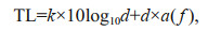 (1)
(1)where k is spread coefficient and is usually set to 2 when the signal propagation is assumed as sphere spread, d denotes communication distance, and α(f) represents absorption coefficient that is a function of the acoustic signal frequency (f). When f is less than 50 kHz, α(f) is expressed as the Thorp formula:
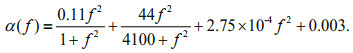 (2)
(2)Equations 1 and 2 suggest that the value of TL increases with increasing f and increasing d (Baggeroer, 1984). Thus, we should select the frequency from the band of relatively small values. On the other hand, the underwater communication rate is positively proportional to the frequency (Baggeroer, 1984). To warrant the relatively high communication rate, we thus cannot choose a very small frequency. Based on the above considerations, we thrashed out a suitable compromise frequency of 9–15 kHz.
Next, we determine the modulation for underwater acoustic communication. Underwater acoustic communication suffers low bandwidth utilization, poor energy efficiency, and multipath and noisy environment in the underwater channel. Both the reliability and energy efficiency of the modem should be considered. We thus adopt two modulations together, including Multiple Frequency-Shift Keying (MFSK) and Quadrature Phase-Shift Keying (QPSK). MFSK modulation has high reliability and a low communication rate in the underwater data transmission, and the situation is reversed for QPSK modulation. For the frequency band of 9–15 kHz, MFSK modulation has only a 320-bps communication rate. In contrast, QPSK modulation has a 6 000-bps rate with the usage of a bi-directional Turbo equalization technique (Xi et al., 2018). However, the power outputs of the transmitting modem are comparable for MFSK (80 Watts) and QPSK (100 Watts) modulations when accomplishing a maximum 7 km data transmission with a (9–15)-kHz frequency band. This suggests that QPSK modulation affords better rate band ratio and energy efficiency, which are 18.75 times and 15 times higher than that of MFSK modulation. The detailed parameters of MFSK and QPSK are given in Table 1.

The combined scheme of MFSK and QPSK modulations for transmitting data works in the following way (Fig. 2). The QPSK modulation only transmits observation data, while the MFSK modulation transmits not only the observation data but also the communication handshake command. One record of observation data will first be divided into several small QPSK data frames. If any QPSK frame transmission error occurs, the receiver will return the error frame ID to the sender, and the error QPSK frame will be sent once again. If the error remains occurring, the QPSK frame will be further divided into several MFSK subframes, and the modem will send data with MFSK modulation. For example, a record of one-hour velocity profile data observed by two ADCPs is divided into 12 QPSK frames, and when necessary, each QPSK frame is further divided into 12 MFSK subframes.

|
| Fig.2 The combined scheme of MFSK and QPSK modulations for transmitting observation data |
To ensure the reliability of data transmission, a simple but effective handshake strategy, i.e., the check-retransmission mechanism is applied to reduce the transmission error rate. According to the strategy, the underwater acoustic modem is the client node, while the surface acoustic modem on the buoy is the slave node. When any observation data from the underwater instrument is conveyed to the client node, the client node will wake from hibernation and trigger a data transmission process that combines the two modulations mentioned above. The process is demonstrated in Fig. 3. The data transmission includes three stages. In the first stage, the client node sends a Request To Send (RTS) command to the slave node, and if the slave node wakes up and confirms the command, it returns a Confirm To Send (CTS) command to the client node. When the client node receives the CTS correctly, it sends observation data to the slave node through QPSK modulation. Then the slave node does the Cyclic Redundancy Check (CRC) and returns the acknowledgment (ACK) to the client node. If the slave node successfully receives the data, the data are demodulated through QPSK and are sent to the satellite modem. If the slave node fails in receiving the whole data, the mechanism goes to the second stage. In the second stage, if any frame error occurs, the slave node returns the number of the error frame. The client node only resends the error frame through QPSK modulation to the slave node. Then the slave node does the CRC again and returns the ACK to the client node. If the slave mode still fails in receiving the whole data, the mechanism goes to the third stage. In the third stage, if any frame error still occurs, the client node further divides the frame into several subframes and sends the subframes through MFSK modulation. Then the slave node repeats the CRC but no longer returns the ACK to the client node. If there still exists any error, this record of data is left alone.

|
| Fig.3 The data transmission process between the underwater client acoustic modem and surface slave acoustic modem RTS: Request To Send; CTS: Confirm To Send; CRC: Cyclic Redundancy Check; ACK: Acknowledgment; MFSK: Multiple Frequency-Shift Keying; QPSK: Quadrature Phase-Shift Keying. |
The acoustic communication subsystem can afford real-time transmission of multiple instruments data through acoustic modem networks. Given that the frequency band (9–15 kHz) of the modem is insufficient to support various pairs of modem communication simultaneously, a time division multiple access method is applied. In each data transmission cycle, the client modem in connection with two ADCPs transmit data first according to the process shown in Fig. 3, and then the surface slave modem sends a data transmission command to other client modems one by one, which afterward send the data to the surface modem through QPSK modulation sequentially.
2.3 Satellite communication subsystemIn our RTSMs, we use the Iridium or Beidou satellite to transmit data from the surface buoy to the office. The Iridium satellite system is a wireless communication network providing a robust suite of data services to any destination anywhere on earth. It comprises three principal components, including the satellite network, the ground network, and the subscriber modems. Iridium has two types of transmission services, including Short Burst Data (SBD) and Router-Based Unrestricted Digital Internetworking Connectivity Solutions (RUDICS). The SBD applies to the transmission of short data messages, while the RUDICS applies to large data transfers. Given that there was only one RTSM in 2016, we used the Iridium SBD service to send data to the email address. In 2017 and 2018, the number of our RTSMs increased to 10 sets, resulting in a significant increase in data amount. Thus, we used RUDICS instead of SBD.
We also use China self-developed Beidou satellite to transmit data in RTSMs. Beidou satellite system can provide positioning, short message telecommunication, and timing services globally. The amount of data transmission by the single Beidou SIM card is 78 bytes per minute, while the total data amount of two ADCPs is about 2 700 bytes per hour. This suggests that the single SIM card needs more than half an hour to transmit all data back in the one-hour cycle, which cannot be applied in our RTSMs due to high power consumption. To solve the above problems, we developed a multi-card Beidou satellite modem consisting of 16 card slots. These slots are stacked two layers to save the volume of the modem. The observed data are first divided into several small segments and then are transmitted back simultaneously using multiple SIM cards. After the server receives all segmental data, these data will be jointed to the original record again. Two ADCPs data of one hour can be transmitted back in about 3 minutes through the multi-card Beidou modem.
3 DEVELOPMENT PROCESS AND SEA TRIAL 3.1 Year 2016In 2016, the first version of RTSM was developed and then successfully deployed at the equator of 142°E on 10 December 2016. In this version, one transducer and three hydrophones are equipped on the surface communication buoy to warrant a high signal noise power rate at the receiving end, and one underwater acoustic modem is connected with two ADCPs. The log file shows that more than 96% of underwater acoustic communication succeeded through QPSK modulation at the first stage. The satellite communication scheme adopted Iridium SBD, and the real-time data were sent to the user through email. Figure 4 shows the time-depth variations of real-time transmitted zonal and meridional velocities. This RTSM succeeded in persisting working for more than 260 days from 10 December 2016 to 28 August 2017, suggesting that the full link for real-time data transmission from the underwater sensor to the user is successfully established. During the period from 11 to 20 February 2017, the main float was flowed downward from 400 m to 480 m by the strong upper ocean currents, resulting in the diving of the surface communication buoy and the suspending of real-time transmission of data. This implies that the net buoyancy of the main float needs to be enhanced. Another defect of this version is the lack of continuous transmission on the breakpoint. This leads to the vacancy of real-time data when the surface buoy dives or the satellite signal is weak. The real-time transmission gradually failed due to battery failure since 21 July 2017. The defects in the lack of continuous transmission on the breakpoint, insufficient buoyancy of the main float, and battery failure will be improved.

|
| Fig.4 Time-depth variations of real-time transmitted zonal (U) and meridional (V) velocities observed by ADCPs based on wireless acoustic communication from 10 December 2016 to 28 August 2017 at 0°, 142°E |
In 2017, we made substantial improvements for the RTSM in the following five aspects. First, to avoid diving of surface buoy, we added a group of four glass floatation spheres (~100 kg net buoyancy) at a depth of 20 m shallower than the main float. This adds a net buoyancy of about 100 kg to the main float part. In addition, the surplus length of Kevlar cable between the surface buoy and the main float increases from 150 m to 250 m. Second, the function of continuous transmission on the breakpoint is added to the RTSMs. If the satellite communication fails, the observation data will be stored in the memory card and labeled as failed transmission data. In the next cycle of data transmission, these data will be sent to the satellite in a reversed sequence of time. Third, considering the good performance of underwater acoustic communication in 2016, we only equipped one transducer and one hydrophone on the surface communication buoy to cut the cost. Forth, to realize the real-time transmission of much deeper data, we developed a small-sized compact modem to connect with one CTD and one current meter at about 3 000 m depth. Fifth, given the requirement for large amounts of data transfer, the satellite scheme was changed from Iridium SBD to Iridium RUDICS, which can effectively reduce the satellite communication fee.
In order to examine the performance of RTSMs extensively, we deployed 10 updated RTSMs in the CASSON in the western Pacific at the end of 2017. All RTSMs could transmit three-dimensional velocities in real-time over upper 1 000 m observed by two ADCPs, and one of RTSMs (139°E, 11.6°N) could further realize real-time transmission of pointwise temperature, salinity, and horizontal velocity at about 3 000-m depth. We took the RTSM at 139°E, 11.6°N as an example, and ploted the time-depth variations of its real-time transmitted results (Fig. 5). Although the number of surface hydrophones was reduced to one, more than 95% of underwater communication still succeeded through QPSK modulation at the first stage. The continuous running periods of these RTSMs varied from 124 to 346 days, with an average of 226 days. Benefiting from the enhanced buoyancy in the main float of RTSM and the function of continuous transmission on the breakpoint, more than 90% of observed data were transmitted successfully to the office. In summary, extensive application in the western Pacific further verified the reliability of the whole working procedure of RTSM, and the depth of real-time data was extended to 3 000 m. However, the surface buoy has a high risk of loss due to shipping and/or fishing damages. This restricts the continuous running periods of RTSMs and needs to be optimized in the future.

|
| Fig.5 Time-depth variations of real-time transmitted zonal and meridional velocities (U and V) observed by ADCPs (a–b), deep temperature and salinity (T and S) observed by CTD (c), and deep U and V observed by current meter based on wireless acoustic communication (d) from 7 December 2017 to 17 November 2018 at 11.3°N, 139.6°E |
In 2018, we made further improvements for the RTSMs based on the sea trial performance in 2017, and expanded their functions. Our previous version of RTSM could not realize the real-time transmission of upper ocean temperature and salinity at depths shallower than the main float. Temperature and salinity in the upper layer varied significantly with time and depth, and thus need to be observed by multiple sensors with small depth interval. To realize the real-time transmission of these data, we adopted inductive coupling communication from the view of the cost economy. Therefore, we integrated inductive coupling and acoustic communication subsystems in one RTSM. In this RTSM, two communication subsystems have their independent satellite modems at the surface buoy, and the Kevlar cable between the surface buoy and the main float is replaced by the communication cable. Besides, we got rid of one hydrophone and retained only one transducer in connection with the surface acoustic modem, and replaced two glass floatation spheres with one through packing satellite modem, acoustic modem, and battery together. The above refinements can further cut the cost of RTSM. The Beidou multi-card modem was developed to transmit real-time data in some RTSMs.
We deployed 10 updated RTSMs in the western Pacific at the end of 2018. All RTSMs were able to transmit three-dimensional velocities in real-time over the upper 1 000 m observed by two ADCPs. One of RTSM (130°E, 11°N) could further realize the real-time transmission of pointwise temperature, salinity, and horizontal velocity at about 1 500, 2 000, 3 000, 4 000, and 5 000 m through acoustic communication, and pointwise temperature and salinity from 50 to 350 m with a vertical interval of ~50 m through inductive coupling communication. All real-time transmitted results from the RTSM at 130°E, 11°N are shown in Fig. 6. This mooring continuously runs for 245 days. From June to mid-July 2019, one energetic downwelling eddy occupied the site of this RTSM, resulting in the main float moving downward and the surface buoy diving into the water, and therefore observation data failed to be real-time transmitted back. Fortunately, the function of continuous transmission on the breakpoint resends part of these data afterward. Note that the inductive coupling communication subsystem can only resend the failed transmission data in the latest one week. The continuous running periods of 10 RTSMs varied from 176 to 308 days, with an average of 268 days. The increase in the continuous running period from 2017 to 2018 probably benefits from the reduced size of the surface buoy.

|
| Fig.6 Time-depth variations of real-time transmitted upper ocean temperature and salinity (T and S) observed by CTDs based on inductive coupling communication (a–b); and zonal and meridional velocities (U and V) observed by ADCPs (c–d); deep T and S observed by CTDs, and deep U and V (vectors) observed by current meters based on wireless acoustic communication (e–i) from 5 December 2018 to 7 August 2019 at 11.0°N, 130.0°E |
Through three-year field trials of RTSMs in the western Pacific, the design, communication procedure, and power consumption have been gradually optimized, which enhanced the operation stability and persisting working period of RTSMs. The depth of real-time transmitted data has been extended from 1 000 m to about 5 000 m, and both Beidou and Iridium satellites could be used to transmit data.
4 RESEARCHES ENABLED BY REAL-TIME SUBSURFACE MOORINGRTSMs have high potential values on many aspects of ocean and climate studies. The RTSMs can provide real-time ocean information at the subsurface and deep layers, which, for example, plays a vital role in the ENSO and internal wave predictions. Figure 7a & b shows the time-depth variation of real-time transmitted zonal velocity at the surface obtained from the Ocean Surface Current Analyses Real time (OSCAR) dataset (Bonjean and Lagerloef, 2002) and over 15–800 m observed by two ADCPs from 7 January 2014 to 1 July 2019 at 4.7°N, 140.0°E. Two dominant zonal currents in the upper 800 m have been revealed: the eastward-flowing North Equatorial Countercurrent (NECC) generally lying in the upper 200 m with a maximum speed exceeding 100 cm/s, and the North Equatorial Subsurface Current (NESC) between 200–800 m depths with a maximum speed exceeding 10 cm/s. The depth ranges and velocities of the NECC and NESC varied significantly. The NECC deepened into about 300 m and intensified in flow speed in the El Niño year of 2015, then shoaled and weakened from 2016 to mid-2017, gradually re-deepened and intensified from mid-2017 to 2018, and shoaled and weakened again in 2019. The NESC was featured by eastward-westward oscillation at the intraseasonal timescale. Next, we calculate the lead-lag correlation between the Niño 3.4 index and 11-day running-mean zonal velocities at different depth (Fig. 7c). For the surface zonal velocity obtained from OSCAR, the correlation can reach up to 0.57 with U leading the Niño 3.4 index by 131 days, and then gradually decreases when the U leading time decreases. For the subsurface U obtained from the RTSM, the correlation is 0.54 at 210 m depth when U also leads the Niño 3.4 index by 131 days, and unlike the surface current, the correlation will increase to ~0.70 when theU leading time decreases. The high correlation region is generally located at the boundary layers between the NECC and NESC, corresponding to the thermocline depth. This suggests that the variability of zonal current near the thermocline is a more effective precursor for ENSO than that at the surface layer. This finding is broadly consistent with previous studies (e.g., Clarke, 2014) that suggest the high ability of the thermocline depth in predicting ENSO.

|
| Fig.7 Time-depth variation of zonal velocity (U) at the surface obtained from OSCAR (a) and over 15–800 m observed by ADCPs (b) from 7 January 2014 to 1 July 2019 at 4.7°N, 140.0°E; the lead-lag correlation (color) between the Niño 3.4 index and 11-day running-mean U (c) The correlation for surface current is plotted over 0-30 m depth. A negative lag indicates U leading the Niño 3.4 index, and vice versa. |
An ongoing work evaluated the impact of assimilation of moored currents into an eddy-permitting ocean model based on a low-frequency scale-selective ensemble optimal interpolation scheme (Liu et al., Impact of assimilation of moored velocity data on low-frequency current estimation in northwestern tropical Pacific, submitted to Journal of Geophysical Research: Oceans, under review). The results show that the assimilation of subsurface current efficiently resolved the simulated low-frequency current, and the root mean square error of simulated velocity relative to the moored velocity at 500 m depth was reduced by 47%.
5 CONCLUSIONIn order to realize the real-time transmission of subsurface and deep ocean current and hydrography data, we developed a new type of real-time subsurface mooring (RTSM). The RTSM transmits subsurface and deep ocean data to the surface buoy mainly through underwater acoustic communication, and then to the office through Beidou or Iridium satellite. After the development of RTSM, we conducted extensive sea trials in the western Pacific from 2016 to 2018. These sea trials demonstrate that the full link for real-time data transmission from the underwater sensor to the office has been established successfully, and the underwater acoustic communication with MFSK and QPSK modulations is an effective method for remote data transmission in the water. Based on the performances of RTSM in the open ocean, some substantial improvements were made to enhance their continuous running days, the successful rate of data transmission, and the depth range of real-time data. We found that the continuous running days are related mainly to the size of the surface buoy. Therefore, we used one glass sphere instead of two to construct the surface buoy, packing satellite modem, acoustic modem, and battery together. In 2018, the average continuous running days reached 268 days. To improve the success rate of data transmission, we added the function of continuous transmission on the breakpoint, and decreased the probability of the diving of the surface buoy through increasing the net buoyancy of the main float part and surplus length of Kevlar cable between the surface buoy and the main float. This warrants that more than 90% of observed data can be transmitted effectively back to the office. In order to increase the depth range of real-time data, we developed a small-sized compact acoustic modem to realize the real-time transmission of deep ocean data up to 5 000 m. Besides, we made some efforts on the cost reduction without influencing the communication quality, including that the number of surface transducer and hydrophones decrease from four to one, and the Iridium satellite communication scheme was changed from SBD to RUDICS.
Observing the ocean in real-time is the sought of the oceanographic and climate community. After the achievement of real-time transmissions of surface and upper ocean data in the 1980s and 1990s, scientists have put much effort into the system development in the realization of real-time transmission of subsurface and deep ocean data. In this study, we introduce a new system of RTSM mainly based on underwater acoustic communication. The performance of this RTSM was verified in the continuous run in the western Pacific, and its function has been gradually refined. We further combined underwater acoustic and inductive coupling communications in one RTSM to realize the real-time recovery of nearly full-depth ocean data. It is suggested that the inductive coupling communication is more applicable to the sensor network in the upper ocean with small depth intervals and short transmission distance to the surface. In contrast, acoustic communication is more suitable to the sensor network with large depth intervals and long transmission distance to the surface.
Improving the reliability of ocean circulation and climate predictions requires the continuous real-time data from the subsurface and even deep ocean, which proposes the demand for the RTSM. Our preliminary analysis has demonstrated that the subsurface zonal velocity near the thermocline in the western Pacific is a more effective precursor for ENSO prediction than the surface zonal current. Considering its high cost, the RTSM can be preferentially deployed in the critical regions for the ocean circulation and climate predictions (e.g., Hu and Duan, 2016; Wang et al., 2017; Hu et al., 2019). As a beneficial supplement to the real-time surface buoy and mobile Argo and glider, we hope the RTSM can become a promising component of the global ocean observing system.
6 DATA AVAILABILITY STATEMENTThe OSCAR (Ocean Surface Current Analyses Real time) data are obtained from https://podaac.jpl.nasa.gov/dataset/OSCAR_L4_OC_third-deg. The Niño-3.4 Index is downloaded from https://www.esrl.noaa.gov. The mooring data used here can be accessed freely for research purpose upon request to WANG Fan (fwang@qdio.ac.cn).
7 ACKNOWLEDGMENTWe are sincerely grateful to all the researchers, staff, and the crew of R/V Kexue (Science) for their efforts in the sea trails of the real-time subsurface moorings. We thank three anonymous reviewers for constructive comments.
Ando K, Kuroda Y, Fujii Y, Fukuda T, Hasegawa T, Horii T, Ishihara Y, Kashino Y, Masumoto Y, Mizuno K, Nagura M, Ueki I. 2017. Fifteen years progress of the TRITON array in the Western Pacific and Eastern Indian Oceans. Journal of Oceanography, 73(4): 403-426.
DOI:10.1007/s10872-017-0414-4 |
Baggeroer A. 1984. Acoustic telemetry-an overview. IEEE Journal of Oceanic Engineering, 9(4): 229-235.
DOI:10.1109/JOE.1984.1145629 |
Barnston A G, Tippett M K, L'Heureux M L, Li S H, DeWitt D G. 2012. Skill of real-time seasonal ENSO model predictions during 2002-11: is our capability increasing?. Bulletin of the American Meteorological Society, 93(5): 631-651.
DOI:10.1175/BAMS-D-11-00111.1 |
Bonjean F, Lagerloef G S E. 2002. Diagnostic model and analysis of the surface currents in the tropical Pacific Ocean. Journal of Physical Oceanography, 32(10): 2 938-2 954.
DOI:10.1175/1520-0485(2002)032<2938:DMAAOT>2.0.CO;2 |
Clarke A J. 2014. El Niño physics and El Niño predictability. Annual Review of Marine Science, 6: 79-99.
DOI:10.1146/annurev-marine-010213-135026 |
Gao J, Wang J N, Wang F. 2019. Response of near-inertial shear to wind stress curl and sea level. Scientific Reports, 9(1): 20417.
DOI:10.1038/s41598-019-56822-z |
Hoteit I, Cornuelle B, Heimbach P. 2010. An eddy-permitting, dynamically consistent adjoint-based assimilation system for the tropical Pacific: hindcast experiments in 2000. Journal of Geophysical Research: Oceans, 115(C3): C03001.
DOI:10.1029/2009JC005437 |
Hu J Y, Duan W S. 2016. Relationship between optimal precursory disturbances and optimally growing initial errors associated with ENSO events: implications to target observations for ENSO prediction. Journal of Geophysical Research: Ocean, 121(5): 2 901-2 917.
DOI:10.1002/2015JC011386 |
Hu J Y, Duan W S, Zhou Q. 2019. Season-dependent predictability and error growth dynamics for La Niña predictions. Climate Dynamics, 53(1-2): 1 063-1 076.
DOI:10.1007/s00382-019-04631-5 |
Köhl A. 2015. Influence of assimilating transports and in situ data from the Rapid-MOCHA array into the GECCO2 ocean synthesis. Dynamics of Atmospheres and Oceans, 72: 38-51.
DOI:10.1016/j.dynatmoce.2015.09.001 |
Ma Q, Wang F, Wang J N, Lyu Y. 2019. Intensified deep ocean variability induced by topographic Rossby waves at the Pacific Yap‐Mariana Junction. Journal of Geophysical Research: Oceans, 124(1): 8 360-8 374.
DOI:10.1029/2019JC015490 |
Morrison A T, Billings J D, Doherty K W. 2000. The McLane moored profiler: an autonomous platform for oceanographic measurements. In: Proceedings of OCEANS 2000 MTS/IEEE Conference and Exhibition.IEEE, Providence, RI, USA. p.353-358, https://doi.org/10.1109/oceans.2000.881284. 10.1109/oceans.2000.881284
|
Send U, Fowler G, Siddall G, Beanlands B, Pittman M, Waldmann C, Karstensen J, Lampitt R. 2013. SeaCycler: a moored open-ocean profiling system for the upper ocean in extended self-contained deployments. Journal of Atmospheric and Oceanic Technology, 30(7): 1 555-1 565.
DOI:10.1175/JTECH-D-11-00168.1 |
Song L N, Li Y L, Wang J N, Wang F, Hu S J, Liu C Y, Diao X Y, Guan C. 2018. Tropical meridional overturning circulation observed by subsurface moorings in the Western Pacific. Scientific Reports, 8(1): 7 632.
DOI:10.1038/s41598-018-26047-7 |
Tian C, Deng Z D, Xu X Y, Yang Q X, Zhao W. 2015. Timed communication buoy system: a subsurface mooring system for efficient sensor data recovery. Marine Technology Society Journal, 49(3): 117-126.
DOI:10.4031/MTSJ.49.3.7 |
Wang F, Wang J N, Guan C, Ma Q, Zhang D X. 2016. Mooring observations of equatorial currents in the upper 1000 m of the western Pacific Ocean during 2014. Journal of Geophysical Research: Oceans, 121(6): 3 730-3 740.
DOI:10.1002/2015JC011510 |
Wang J N, Lu Y Y, Wang F, Zhang R H. 2017. Surface current in "hotspot" serves as a new and effective precursor for El Niño prediction. Scientific Reports, 7(1): 166.
DOI:10.1038/s41598-017-00244-2 |
Xi J Y, Yan S F, Xu L J. 2018. Direct-adaptation based bidirectional turbo equalization for underwater acoustic communications: algorithm and undersea experimental results. The Journal of the Acoustical Society of America, 143(5): 2 715-2 728.
DOI:10.1121/1.5036730 |
Zhang Z X, Pratt L J, Wang F, Wang J N, Tan S W. 2020. Intermediate intraseasonal variability in the western tropical Pacific Ocean: meridional distribution of equatorial Rossby waves influenced by a tilted boundary. Journal of Physical Oceanography, 50(4): 921-933.
DOI:10.1175/JPO-D-19-0184.1 |