 2020, Vol. 38
Institute of Oceanology, Chinese Academy of Sciences
Article Information
- CAI Laixing, XIAO Guolin, ZENG Zhigang, ZHANG Xunhua, GUO Xingwei, WANG Shuping
- New insights into marine hydrocarbon geological conditions in the South Yellow Sea Basin: evidence from borehole CSDP-2
- Journal of Oceanology and Limnology, 38(4): 1169-1187
- http://dx.doi.org/10.1007/s00343-020-0068-8
Article History
- Received Jan. 28, 2020
- accepted in principle Mar. 15, 2020
- accepted for publication Mar. 28, 2020


2 Laboratory for Marine Mineral Resources, Pilot National Laboratory for Marine Science and Technology (Qingdao), Qingdao 266237, China;
3 Qingdao Institute of Marine Geology, China Geological Survey, Qingdao 266071, China;
4 Oil Industry Training Center, China University of Petroleum (East China), Qingdao 266580, China
Compared with the Upper and Middle Yangtze blocks containing several supergiant oil-gas reservoirs (Borkloe et al., 2016; Han et al., 2016; Feng et al., 2018; Yang et al., 2018), the South Yellow Sea Basin (SYSB) shows similar tectonic setting and sedimentary strata in the Mesozoic and Paleozoic (Zhang et al., 2015; Pang et al., 2017a, 2018; Wu et al., 2019), but has no industrial breakthrough in marine oil and gas (Zhang et al., 2015, 2019b; Pang et al., 2017a, 2019a; Cai et al., 2019, 2020). Although the predicted total amount of marine hydrocarbons in SYSB can reach (27.50–35.37)×108 t (Hu, 2010; Tan et al., 2018), its oil and gas prospects are still unclear, which has always attracted the attention of petroleum geologists (Yi et al., 2003; Li et al., 2013, 2014; Choi et al., 2015; Cai et al., 2019, 2020; Wu et al., 2019).
Earlier in this decade, the petroleum targets in SYSB shifted from the Mesozoic-Cenozoic continental strata to the Mesozoic-Paleozoic marine strata, acting on the proposal of "the second round of oil and gas exploration in China" (Liu, 2002) and the continuous breakthroughs in marine oil and gas exploration in South China (Korsch et al., 1991; Ma et al., 2008, 2017; Wei et al., 2008; Xie et al., 2013; Borkloe et al., 2016; Chen et al., 2017; Yang et al., 2018). Much research work focusing on hydrocarbon geological conditions has been carried out while conducting geophysical investigations in this sea area, including the plate-tectonic mechanism and tectono-thermal evolution (Xu et al., 2009; Hao et al., 2010; Zhang et al., 2015; Pang et al., 2017b; Zhao et al., 2017), hydrocarbon source rocks (Cao et al., 2009; Xiao et al., 2017; Cai et al., 2019; Chen, 2019; Pang et al., 2020b), reservoir characteristics (Zhang et al., 2016; Cai et al., 2020) and source-reservoir-caprock assemblages (Wang et al., 2005; Yuan et al., 2017, 2019).
However, against the background of the interaction between the Western Pacific and Eurasian plates (Suo et al., 2012; Jiang et al., 2017; Pang et al., 2018, 2020a; Xu et al., 2019), numerous challenges have been encountered in the investigation and exploration of marine hydrocarbons in SYSB. The Mesozoic and Paleozoic strata in this basin have suffered multistage tectonic movements during their long geological evolution history, resulting in geophysical exploration issues, unclear hydrocarbon potential and distribution (Wu et al., 2019; Zhang et al., 2019b). The previous discussion on the relationship among source rocks, reservoirs, and caprocks mostly relied on predictions, lacking the support of testing data (Yuan et al., 2017, 2019). In addition, only four exploration wells in SYSB had penetrated Paleozoic strata by 2015, and the oldest stratum revealed was the Carboniferous Gaollishan Formation (Liang et al., 2017; Pang et al., 2017a; Cai et al., 2019; Wu et al., 2019). The severe lack of first-hand cores also greatly limits the exploration process.
In October 2016, borehole CSDP-2 achieved the continuous coring of 2 843.18 m with an average harvesting rate of 97.7%, filling the gap in the geological database of SYSB (Cai et al., 2019, 2020; Guo et al., 2019; Pang et al., 2019a; Wu et al., 2019; Zhang et al., 2019b). Beneath Neogene strata, borehole CSDP-2 successively penetrated Mesozoic Triassic, Upper Paleozoic Permian, Carboniferous, and Devonian strata. Lower Paleozoic Silurian strata were first encountered in SYSB, revealing the existence of thick marine strata (Cai et al., 2019, 2020; Guo et al., 2019; Zhang et al., 2019b). By using the cores and corresponding testing data of this borehole, the source rocks, reservoirs, and caprocks can be accurately identified, and the source-reservoircaprock assemblages can be established by means of oil-source rock correlation analysis. New insights from this work can provide more accurate targets and more reasonable scientific bases for marine hydrocarbon exploration in SYSB.
2 GEOLOGICAL BACKGROUNDSYSB, as an extension of the Lower Yangtze block in the eastern sea area, is connected with the Subei Basin on land, which is collectively known as the Subei-South Yellow Sea Basin (Pang et al., 2003; Wu et al., 2019; Xu et al., 2019b; Cai et al., 2020). This basin is mainly bounded by peripheral faults, with the Qianliyan fault and the Sulu-Imjingang orogenic belt in the north and the Jiangshan-Shaoxing fault zone in the south. With the Tanlu fault zone as a boundary, it is adjacent to the North China block in the northwest (Fig. 1; Lu, 1989; Yao et al., 2005; Zhang et al., 2015, 2019b; Pang et al, 2019a; Cai et al., 2020). Based on available data, the basin can be divided into five second-order tectonic units from north to south, which are the Qianliyan Uplift, Northern Depression, Central Uplift, Southern Depression, and Wunansha Uplift (Fig. 1; Yao et al., 2005; Pang et al, 2017a, 2019a; Xu et al., 2018; Zhu et al., 2018; Cai et al., 2019; Xiong et al., 2019; Zhang et al., 2019a).

|
| Fig.1 Geographical position and tectonic divisions of the South Yellow Sea Basin |
Borehole CSDP-2, funded by the Continental Shelf Drilling Program (CSDP), is located at the intersection of latitude 34°33′18.9″N and longitude 121°15′41.0″E, approximately 170 km southeast to Lianyungang City and 110 km northeast to Sheyangkou County town (Fig. 1). This borehole is not only the unique continuous coring well in SYSB but also penetrates the Silurian strata for the first time (Cai et al., 2019; Guo et al., 2019; Pang et al., 2019a). Comprehensive analysis of seismic, logging and drilling data reveals that the Indosinian unconformity surface in borehole CSDP-2 is located at a depth of 629.0 m, on which are deposited Quaternary and Neogene strata. The Lower Triassic Qinglong Formation (T1q) is developed from 629.0 to 863.3 m, and mainly consists of calcareous mudstones and argillaceous limestones. The Upper Permian Dalong Formation (P2d), located between approximately 863.3 m and 914.8 m, contains clastic deposits dominated by gray siltstones, fine sandstones and dark gray mudstones. From 914.8 m to 1 636.6 m, a sandstone-mudstone combination with thin coal seams occurs, which is called the Longtan Formation (P2l). The Lower Permian strata in borehole CSDP-2 are composed of the Gufeng Formation (P1g) siliceous mudstones and the Qixia Formation (P1q) swinestones, carbonaceous mudstones and mudstones. Under the Permian strata, the Carboniferous limestone layers are encountered in the depth interval of 1 722.2–2 022.8 m. Subsequently, from 2 022.8 m to 2 205.0 m, there are the interbedded quartz sandstones and mudstones of the Upper Devonian Wutong Formation (D3w). Below this stratigraphic boundary of the Caledonian unconformity (Wang et al., 2007; Liu et al., 2010; Xu et al., 2019b), this borehole drilled into the Lower Silurian strata and eventually encountered the Gaojiabian Formation (S1g) mudstones (Fig. 2).

|
| Fig.2 Stratigraphic column of borehole CSDP-2 in the South Yellow Sea Basin GR is the gamma logging curve in units of API; AC is the acoustic logging curve in units of μs/ft; RLLD is the deep-lateral logging curve in units of Ω·m; RLLS is the shallow-lateral logging curve in units of Ω·m; Db5 is the wavelet type; a is the scale parameter; and 512 is the selected parameter. |
In this study, 390 core samples selected from borehole CSDP-2 were tested to characterize the quality of the source rocks, reservoirs, and caprocks, ensuring the research reliability. Of these, 295 samples were used for organic geochemistry analysis, including organic matter maturity, type, and abundance, as well as oil-source rock correlation analysis. In addition, 61 samples were tested to determine the reservoir porosity and permeability, and 14 samples analyzed to evaluate the sealing performance were mostly obtained from the Lower Triassic and Carboniferous rocks. Another 20 doublepolished thin sections were prepared for petrographic analysis and homogeneous temperature (Th) measurement of hydrocarbon-bearing fluid inclusions. The samples used for source rock evaluation are scattered cores, and the samples utilized for reservoir and caprock characterization are core plugs with lengths of 4.0 cm and diameters of 2.5 cm.
3.2 Experimental methodA series of back-to-back source rock evaluation experiments were carried out at China University of Petroleum (East China) and Yangtze University. By referring to the research methods of organic geochemistry (Chang et al., 2018; Feng et al., 2018; Seeley et al., 2018; Han et al., 2019b), the vitrinite reflectance (R0) was determined with a DMLPWITH MSP200 microspectrophotometer, and the total organic carbon (TOC) was measured using a Leco carbon-sulfur analyzer. Besides, pyrolytic parameters of the residual hydrocarbon (S1), cracked hydrocarbon (S2), and peak temperature at the maximum point of the S2 peak (Tmax) were obtained from pyrolysis experiments performed on an OGE-Ⅱ rock pyrolysis instrument. Microscopic kerogen examination was carried out using a Leica DM4500P research microscope, and chloroform bitumen "A" was extracted from rocks by an accelerated solvent extraction (ASE300) instrument. Gas chromatography and mass spectrometry (GC-MS) analysis was performed as described by Seeley et al. (2018) and Chang et al.(2017, 2018) using a GC-MS 7890B 5977 instrument (Agilent Technologies Inc.) to identify and quantify terpanes, steranes, and dinosteroids.
At China University of Petroleum (East China Campus), the reservoir porosity and permeability were determined with an Ultrapore-200A helium porosimeter and an Ultra-perm TM 200 gas permeameter, respectively. Furthermore, the reservoir space type and size were mainly identified from thin sections impregnated with blue epoxy and scanning electronic microscopy (SEM) observations (Li et al., 2017; Wang et al., 2017; Shi et al., 2019). The former was performed on a Zeiss Axioscope A1 APOL digital transmission microscope, and the latter was conducted under a Quanta FEG 450 SEM instrument combined with an energy dispersive X-ray spectrometer (EDS). Analysis of the hydrocarbon-bearing fluid inclusions was carried out on a laser Raman microscope equipped with a THMSG 600 (Linkam, UK) heating and cooling stage (-100–500℃). Th was determined at a heating rate of 10℃/min when the temperature was below 50℃ and at a heating rate of 5℃/min between ~50 and 200℃, both of which guaranteed a measurement accuracy within ±1℃ (Xi et al., 2019; Wang et al., 2020b; Yang et al., 2020).
Displacement pressure tests of the caprocks were completed by using a TPYL-II caprock breakthroughpressure test device at Northeast Petroleum University. The nitrogen gas injection pressure started at 0.01 MPa and increased by 15% every 10 min. During the whole test process, the confining pressure was maintained at approximately 5–10 MPa above the injection pressure to prevent gas leakage around the core plug. When bubbles were observed at the outlet, the corresponding pressure difference between the inlet and outlet was recorded as the penetration pressure. The above experiment was repeated under a different constant injection pressure to eliminate potential confounders, as defined in Eq.1:
 (1)
(1)where P is the gas displacement pressure in units of MPa; P2 and P1 are the penetration pressures in units of MPa; and T2 and T1 are the penetration times in seconds.
Schlumberger's PetroMod (2012) software was used to construct a three-dimensional basin model for the hydrocarbon generation, expulsion and accumulation processes, with the main input parameters including stratum thickness, lithology (Cai et al., 2019; Pang et al., 2019a), geological age, erosion events as reported by Pang et al.(2017a, 2019a, b), surface temperature and geothermal gradient derived from Pang et al. (2017b), elements of petroleum system. Boundary conditions, including heat flow (HF), paleo-water depth (PWD) and sediment-water interface temperature (SWIT), were determined by the calculation results from Pang et al.(2019a, b).
4 RESULT 4.1 Multiple sets of hydrocarbon source rocks in SYSB 4.1.1 Three sets of marine source rocks identified by the geochemical data of borehole CSDP-2The statistical results of the organic matter abundance parameters of borehole CSDP-2 indicate that three sets of effective source rocks, the T1q, Upper Permian Longtan-Dalong Formations (P2l-d), and Lower Permian Qixia-Gufeng Formations (P1q-g) source rocks, are contained in the marine strata of SYSB, especially two sets of Permian source rocks with high quality (Fig. 3). As reported by Xiao et al. (2017) and Cai et al. (2019), the TOC content of various source rock samples from borehole CSDP-2 widely ranges from 0.047% to 24.53%, and the average TOC value also ranges from 0.224% in the Lower Silurian mudstones to 2.979% in the P1q-g carbonaceous mudstones, swinestones and siliceous mudstones. Similarly, the hydrocarbon generation potential (S1+S2) varies between a maximum of 8.49 mg/g and a minimum of 0.001 mg/g, exhibiting significant heterogeneity. Unlike the notable fluctuations mentioned before, the distribution range of chloroform bitumen "A" is comparatively concentrated from 0.001%–0.116%, which generally belongs to the organic matter abundance lower than medium grade.

|
| Fig.3 Organic matter abundance of the hydrocarbon source rocks in borehole CSDP-2 |
Taking the TOC histogram as an example (Fig. 3a), the source rocks with higher organic matter abundance than medium grade are mainly concentrated in the Lower and Upper Permian strata. The T1q calcareous mudstones and argillaceous limestones are dominated by poor source rocks, followed by non-source rocks and good source rocks. Although there are a few effective source rocks (poor to the best grade) in the D3w strata, it is not appropriate to define them as a set of regional source rocks considering the coastal depositional background within the semioxidized environment (Cai et al., 2018; Gao et al., 2019). In addition, the TOC content of the Lower Silurian rock samples is generally lower than 0.475%, and 98.91% of the samples are non-source rocks (Fig. 3a). Due to the particular emphasis on the hydrocarbon content rather than just the organic carbon content, most of the other abundance parameters, such as S1+S2, chloroform bitumen "A" and total hydrocarbon content (HC) (Peters, 1986; Hakimi and Ahmed, 2016; Wang et al., 2020a), fall in the range of nonsource rocks but also indicate the P1q-g, P2l-d, and T1q source rocks (Fig. 3b–d).
The data in Fig. 4 indicate that the organic matter is mainly dominated by sapropelic-humic (type Ⅱ2) and humic (type Ⅲ) kerogen with pronounced gas-prone features, which primarily consists of exinite (average of 54.78 vol.%) and vitrinite (average of 40.10 vol.%), suggesting the chief biological source of terrestrial plants. Only a small amount of sapropelic kerogen (type Ⅰ) occurs in the Lower Triassic, Upper Permian, and Carboniferous source rocks, in which sapropelite is the foremost maceral ranging from 38.95 vol.% to 84.45 vol.% with an average of 61.21 vol.%. Moreover, the coexistence of prepeak carbon from C15 to C22 and postpeak carbon from C23 to C29 in the saturated hydrocarbons also denotes a mixed biological source of terrestrial plants and aquatic organisms (Table 1). Consistent with this finding, the input of terrestrial plants leads to the generally low ΣnC21–/ΣnC22+ ratio, especially after the Silurian period. The (C21+C22)/(C28+C29) ratio, which is higher than 1.00 with a maximum value of 7.73, highlights a marine sedimentary environment. The Pr/Ph (pristine/phytane) ratios ranging from 0.12 to 0.93 further support a reducing to strongly reducing water environment (Table 1).

|
| Fig.4 Crossplot of the kerogen microscopic examination results of the hydrocarbon source rocks in borehole CSDP-2 |

|
In terms of the organic matter maturity, all the rock samples already possess the capability to generate hydrocarbons. Except for the low-mature T1q source rocks with R0 values ranging from 0.62% to 0.75%, the deeper remaining samples have entered the mature and overmature stages, and the highest R0 value is 2.24% (Xiao et al., 2017; Cai et al., 2019). Additionally, the measured Tmax values higher than 435℃ account for 91.6% of all the samples, demonstrating that most of the Mesozoic-Paleozoic marine source rocks have entered the mature and highly mature stages (Xiao et al., 2017; Cai et al., 2019). The same discrimination result is also reflected in the carbon preference index (CPI) and the odd-to-even predominance (OEP) parameters of n-alkanes. All the OEP values are lower than 1.10, except for one T1q source rock sample with an OEP value of 2.21, which is in good agreement with the CPI values smaller than 1.38.
Summarizing the above organic geochemical data, three sets of marine source rocks, the T1q, P2l-d and P1q-g source rocks, are well developed in SYSB, and their organic matter is generally characterized by high abundance, appropriate maturity, and gas-prone features. In addition, previous research has indicated two other sets of source rocks in Lower Paleozoic marine strata, namely, the Lower Cambrian and Upper Ordovician-Lower Silurian source rocks (Cheng et al., 2016; Wang et al., 2018). However, they are not analyzed in this paper due to the limited depth of borehole CSDP-2.
4.1.2 Three sets of continental source rocks based on the previous dataWithin the continental strata above the Triassic strata, the Middle Jurassic, Upper Cretaceous and Paleogene source rocks are unevenly distributed in SYSB (Xiao, 2002; Li et al., 2003, 2015; Cao et al., 2009; Gao et al., 2015; Fu et al., 2019; Xiao et al., 2019; Xu et al., 2019a; Song et al., 2020). The Middle Jurassic source rocks with a limited distribution are mainly developed in the Northern Depression near the Qianliyan fault, which is only encountered in Well S1 at present. Of the 12 mudstone samples reported, the TOC ranges from 0.6% to 1.2% in 11 samples and that of the remaining one is 0.5%, indicating an overall moderate to good organic matter abundance. In addition, their organic matters are dominated by types II1 and II2 in low maturity as evidenced by the Tmax values lower than 435℃ (Xiao et al., 2014, 2019). The Upper Cretaceous source rocks are evenly distributed in the Northern Depression, but are sporadically encountered in the Southern Depression. The organic matter evolution of the source rocks in both areas is generally in the low-mature and mature stages, with R0 values varying between 0.46% and 1.02%. The major difference is that the organic matter of the former mainly consists of types Ⅰ and Ⅱ1 kerogen with the TOC varying between approximately 0.59% and 0.92%, while that of the latter belongs to type III kerogen with an average TOC value of 1.57% (Xiao et al., 2014; Zhang et al., 2017).
As effective source rocks with R0 values in the range of 0.45%–0.71%, the Paleogene mudstones, including the Funing Formation and Dainan Formation (Zhang et al., 2017; Xu et al., 2019a; Song et al., 2020), occur widespread in the depression areas in SYSB. The average TOC value of the Funing Formation mudstones in the Northern Depression containing type Ⅱ2 kerogen is only 0.68%, which can be classified as moderate to poor hydrocarbon source rocks. However, the average TOC value of the Funing Formation mudstones in the Southern Depression, represented by wells CZ6-1-1 (A) and CZ6-2-1, is as high as 1.91%, and their kerogens mainly belong to types Ⅰ and Ⅱ1, indicating a good oil-producing potential. The Dainan Formation mudstones in the Southern Depression are in the low-mature stage with R0 around 0.58%, while those in the Northern Depression have not yet entered the petroleum generation window. Taking well CZ6-1-1 (A) as an example, the average TOC content of the Dainan Formation mudstones is approximately 1.03%, which reflects a moderate abundance (Xiao et al., 2014; Zhang et al., 2017; Xu et al., 2019a; Song et al., 2020).
4.2 Two sets of tight sandstone reservoirs 4.2.1 Porosity and permeabilityAs indicated by the porosity and permeability of 61 samples from borehole CSDP-2, the overall reservoir properties are poor. All porosities are lower than 3.0% with an average of approximately 1.23%, and the permeability varies from 0.004 7×10⁻³ μm2 to 0.279×10⁻³ μm2 with an average of 0.036×10⁻³ μm2, which is indicative of typical tight reservoirs (Fig. 5a). However, a promising exploration potential still exists based on the high-yield gas wells with similar reservoir properties in the Sichuan Basin (Liu et al., 2018; Yue et al., 2018; Li et al., 2019). With 0.05×10⁻³ μm2 as the permeability cut-off for hydrocarbon charging (Deng et al., 2018; Yang et al., 2019), the effective reservoirs in SYSB are composed of parts of the P2l-d and Lower Silurian-Upper Devonian (S1–D3) sandstones (Fig. 5a). The permeability of the Carboniferous carbonate rocks is lower than 0.038×10⁻³ μm2, which basically indicates that these rocks are not suitable for filling and storing hydrocarbons (Fig. 5a). In addition, although there is a positive correlation between the porosity and permeability as a whole, the reservoir heterogeneity is high enough that the permeability of samples with a similar porosity can differ by 2 to 3 orders of magnitude (Fig. 5a).

|
| Fig.5 Reservoir properties and space of borehole CSDP-2 a. relationship between the porosity and permeability of the samples from borehole CSDP-2; b. thin section micrograph under plane-polarized light showing residual intergranular pores; c. SEM micrograph showing residual intergranular pores; d. thin section micrograph under plane-polarized light showing secondary dissolution pores in rock fragments; e. SEM micrograph showing secondary dissolution pores in feldspar; f. SEM micrograph showing intercrystalline pores in kaolinite; g. SEM micrograph showing intercrystalline pores in illite; h. thin section micrograph under plane-polarized light showing microcracks. |
The joint observation of thin sections and SEM reveals that various reservoir spaces are developed in the reservoirs of borehole CSDP-2, including residual intergranular pores, secondary dissolution pores, clay intercrystalline pores and microcracks (Fig. 5b–h), and their pore-throat structures are very complicated with notable heterogeneity (Cai et al., 2020). Residual intergranular pores with sizes of 2.0–400.0 μm are uncommon in sandstones due to the strong mechanical compaction and cementation (Fig. 5b–c), and mainly micropores occur such as secondary dissolution pores in feldspar and intergranular pores in clay minerals (Fig. 5d–g). The size of the secondary dissolution pores ranges from the nanometer to micrometer in scale, and most of them are isolated resulting in a relatively poor connectivity (Fig. 5d–e). The intergranular pores within clay minerals, such as kaolinite and illite, are characterized by nanometer sizes, which are generally smaller than 5.0 μm (Fig. 5f–g). Although the microcracks are very narrow down to the micron level, their extension length can reach several centimeters or even decimeters (Fig. 5h), thus significantly enhancing the reservoir permeability.
4.3 Sealing capacity of the caprocksFollowing the evaluation criteria of caprocks in the oil and gas fields of China (Zhang et al., 2014; Zhou et al., 2018), the T1q and Carboniferous deposition layers act as two sets of effective caprocks in SYSB. T1q is thick and has an even horizontal distribution, including the thickness of 234.3 m in borehole CSDP- 2, which is often considered as a regional caprock (Liang et al., 2017; Zhang et al., 2017; Wu et al., 2019). The displacement pressure data measured in borehole CSDP-2 further validate the excellent sealing capability of the T1q caprocks, which generally range from 7.06–13.12 MPa, with an average value of 10.09 MPa. Moreover, the displacement pressures in the lower segment of T1q (depth below 700 m) increase significantly, with an average of 11.22 MPa, which offers a superior sealing stability for hydrocarbon accumulation in the underlying Permian strata (Table 2).
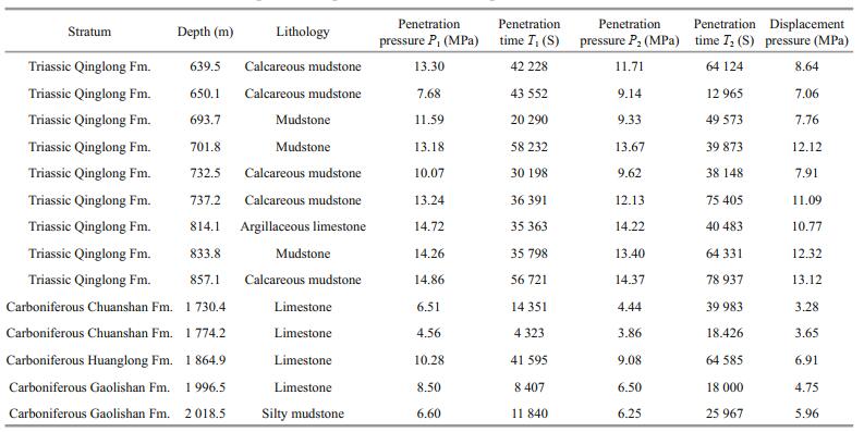
The Carboniferous rocks in SYSB are dominated by limestones and mudstones, with a stable horizon and an accumulated thickness over 300 m (Zhang et al., 2017; Wu et al., 2019; Fig. 2). Although the displacement pressures decrease to 3.28–6.91 MPa with an average of 4.91 MPa (Table 2), a medium to strong sealing capability still exists enabling effective hydrocarbon preservation in the S1–D3 reservoirs (Yuan et al., 2017; Wang et al., 2018; Zhang et al., 2019b).
4.4 Multiple hydrocarbon showsIn borehole CSDP-2, multilevel and multitype oilgas shows have been encountered in several intervals, including the T1q, P2l-d, P1q-g, and S1g layers, which confirms the good petroleum prospects of the Mesozoic-Paleozoic marine strata in SYSB (Fig. 2; Cai et al., 2019). In the sandstones near source rocks or inside thick source rocks, the direct oil shows are mainly oil spots and oil stains, with oil immersion in some parts (Fig. 6a–c). Especially in the P2l sandstones, such as the depth interval of 1 224.3–1 234.2 m, the crude oil seeps out from the reservoir fractures (Fig. 6c; Cai et al., 2019). In addition, gas logging data indicate that there are four high-value anomalous layers distributed in borehole CSDP-2 from top to bottom, namely, 1 330–1 480 m, 1 510–1 840 m, 1 940–2 200 m, and 2 650–2 840 m (Fig. 2). The content of total hydrocarbon can reach up to 66.18%, which is dominated by methane with an average of 87.4% (Fig. 2; Cai et al., 2019). Fluorescent logging data also reflect multiple hydrocarbon-bearing zones, the most prominent of which is located at 1 100–1 600 m in P2l, with the highest equivalent oil content of 44.3 mg/L and an average equivalent oil content of 15.0 mg/L (Fig. 2; Cai et al., 2019).

|
| Fig.6 Hydrocarbon shows in borehole CSDP-2 in the South Yellow Sea Basin -: represents for plane-polarized light. |
The extensive development of hydrocarbonbearing fluid inclusions in borehole CSDP-2 further supports multiple hydrocarbon charging stages in the Mesozoic-Paleozoic marine strata in SYSB. The hydrocarbon inclusions in quartz granules and their healed microfractures are distributed in clustered or zonal distributions (Fig. 6d), whose grains containing oil inclusions (GOI) values are generally less than 4% (Cai et al., 2019), reflecting the relatively small scale of hydrocarbon filling in the early stage. The secondphase inclusions are mainly contained in the subsequent quartz overgrowth, with GOI values ranging from 7%–30% (Fig. 6e; Cai et al., 2019), which corresponds to the major hydrocarbon filling stage. In the calcite cement formed at the late diagenetic stage (Zhang et al., 2016; Cai et al., 2020), the number of hydrocarbon inclusions is so small that their GOI values cannot be determined (Fig. 6f).
5 DISCUSSION 5.1 Near-source hydrocarbon accumulation revealed by oil-source rock correlationThe three oil sand samples obtained in this study are all from the Permian of borehole CSDP-2, and their corresponding depth points are located at 886.3 m in P2d, 1 225.8 m in P2l, and 1 654.7 m in P1q, which are named as the 1#, 2#, and 3# oil sands, respectively. The oil-source rock correlation results indicate that the Permian hydrocarbons in SYSB are characterized by near-source accumulation. The P2d 1# oil sand is closely related to the P2d source rocks and the upper part of the P2l source rocks, while the P2l 2# oil sand has a natural genetic relationship with the lower part of the P2l source rocks. The oil maturity in the P1q 3# oil sand is significantly lower than that in the source rocks in borehole CSDP-2, which may indicate other hydrocarbon sources.
As indicated by the Pr/Ph ratio in Table 1, the source rocks in borehole CSDP-2 can be subdivided into three categories. The Pr/Ph ratios of the type Ⅰ source rocks, distributed above 1 226.2 m, mainly range between 0.47 and 0.93. The type Ⅱ source rocks are concentrated in the depth range of 1 298.2–1 660.6 m, whose Pr/Ph ratios are generally lower than 0.32. The Pr/Ph ratios of the type III source rocks distributed below 2 414.6 m are somewhere in between, ranging from 0.24 to 0.67. In regard to the steranes and terpanes, the scatterplot of C24 tetracyclic terpane/C26 tricyclic terpane vs. C27/C29(αααR) shows two distinct clusters. The P2l 2# oil sand with a C24 tetracyclic terpane/C26 tricyclic terpane ratio of 0.41 and a C27/C29(αααR) ratio of 1.21 is in accordance with some of the characteristics of type Ⅱ source rocks. The C24 tetracyclic terpane/C26 tricyclic terpane ratio and C27/C29(αααR) ratio of the P1q 3# oil sand are 0.52 and 0.91, respectively, which somewhat conform to the characteristics of types Ⅰ and Ⅱ source rocks but are clearly different from those of type Ⅲ source rocks (Fig. 7a). In Fig. 7b, the P1q 3# oil sand with a 18α trisnorhopane/17α trisnorhopane (also known as Ts/Tm) ratio of 0.14 exhibits a significantly lower maturity compared with all the other source rock samples, suggesting that part of the oil may be derived from younger strata. The maturities of the P2d 1# and P2l 2# oil sands are similar to that of these three types of source rocks, revealing a genetic oil-source rock relationship.

|
| Fig.7 Scatterplots of certain biomarker parameters between the oil sand and source rock samples in borehole CSDP-2 |
According to the representative mass chromatograms of hopanes (Fig. 8), the near-source hydrocarbon accumulation phenomenon becomes more prominent. In all samples, the C30 hopane (C30H) content is the highest, followed by that of C29 norhopane (C29H). However, there is a difference in maturity as indicated by the Ts/Tm ratio and gammacerane (Ga) content. The Ts value of the P2d 1# oil sand is notably below the Tm value, and the Ts/Tm ratio is 0.694, representing a relatively low maturity (Fig. 8a). These typical characteristics of a low maturity and high Ga content are highly consistent with those of the P2d source rocks, such as the samples collected at 867.0 and 894.7 m, with Ts/Tm ratios of 0.794 and 0.796, respectively (Fig. 8b–c). In contrast, the P2l 2# oil sand and source rocks are characterized by a low Ga content and a relatively high Ts value and low Tm value, whose Ts/Tm ratio increases significantly to 0.971–1.464 (Fig. 8d–f). Consequently, there are different genetic relationships between the oil sands and source rock samples in P2d and P2l, supporting a near-source hydrocarbon accumulation in the Permian layer. In these tight reservoirs with strong heterogeneity (Fig. 5a), the oil and gas generated from source rocks can hardly migrate in large quantities, thus resulting in the near-source accumulation model.

|
| Fig.8 Representative hopane mass chromatograms for the oil sands and source rock samples in borehole CSDP-2 |
The simulation results of basin modeling indicate that the P1q-g source rocks exhibit two hydrocarbon generation peaks, and the generated hydrocarbon quantity in the first stage is nearly double that in the second stage (Table 3). The later subsidence of the P2l–d and T1q strata failed to compensate for their denudation thicknesses during the Indosinian period (Pang et al., 2019a, 2020a), and a second hydrocarbon generation peak was not observed in the P2l-d and T1q source rocks (Table 3). Most of the P1q-g source rocks in SYSB have entered the mature and highly mature stages (Fig. 9; Xiao et al., 2017; Cai et al., 2019), reaching the first hydrocarbon generation peak at ~230 Ma with a proportion of 62.41% and the second hydrocarbon generation peak at ~208 Ma with a proportion of 32.31% (Table 3). The P2l-d source rocks are currently in the mature stage, whose peak hydrocarbon generation period also occurred at ~208 Ma, with a hydrocarbon generation proportion as high as 95.64%. Then, affected by the Indonesian movement (Pang et al., 2019b), stratum uplift led to the rapid weakening of hydrocarbon generation (Table 3). The T1q source rocks of the Central Uplift are in the immature to low-mature stage due to shallow burial (Fig. 9), exhibiting a limited hydrocarbon generation capacity. However, The T1q source rocks in the Southern Depression are possibly in the mature and highly mature stages (Fig. 9), which exhibit a hydrocarbon generation peak at ~33 Ma, accounting for 71.27% of the hydrocarbon amount (Table 3).

|

|
| Fig.9 Hydrocarbon generation profile along the northwest-southeast direction in the South Yellow Sea Basin, as shown in line A–A' in Fig. 1 |
A hydrocarbon expulsion history similar to the above characteristics is also exhibited by the three sets of source rocks. The maximum hydrocarbon expulsion of the P1q-g and P2l-d source rocks both occurred at ~208 Ma, and their expulsion proportions were high and reached 85.05% and 96.68%, respectively. The expulsion peak of the T1q source rocks appeared at ~33 Ma, which is the same as the generation peak, but the expulsion proportion decreased slightly to 64.72% (Table 3).
Except for the T1q source rocks, the hydrocarbon accumulation with two charging peaks is also observed for both the P1q-g and P2l-d source rocks, and the accumulation amount in the first stage is much larger than that in the second stage (Table 3). The hydrocarbon charging of the P1q-g source rocks started at ~250 Ma and reached its first peak at ~208 Ma, with an accumulation amount of 72.30%. From 80–33 Ma ago, the second charging stage occurred, but only 20.16% of the accumulation amount was accrued (Table 3). The charging process of the P2l-d source rocks started later, reaching its first peak at ~65 Ma, with an accumulation amount of 72.64%. After ~33 Ma, the second charging stage of the P2l-d source rocks and continued charging of the T1q source rocks occurred simultaneously, effectively promoting hydrocarbon accumulation (Table 3).
In summary, three sets of marine source rocks guaranteed a crucial material foundation for hydrocarbon accumulation in SYSB, especially the Permian source rocks with a high hydrocarbon generation capacity and potential. In addition, the other three sets of continental source rocks also provided certain amounts of hydrocarbons through faults (Figs. 9 & 10), establishing multisource supply characteristics. Over geological time, hydrocarbon generation in successive periods and hydrocarbon charging in stages determined the characteristics of multistage accumulation (Table 3).

|
| Fig.10 Diagrammatic sketch of marine hydrocarbon accumulation in the South Yellow Sea Basin, as shown in line B–B' in the northwest-southeast direction in Fig. 1 |
Controlled by the depositional setting of marinecontinental transitional facies (Cai et al., 2017, 2018), the Permian sandstones, mudstones, and thin coal seams superimposed in SYSB are favorable for hydrocarbon migration over short distances. Since 252–250 Ma, the P1q-g, P2l-d, and T1q source rocks have been continuously generating and expelling hydrocarbons (Table 3) that were injected into the nearby P2l-d sandstones. Together, they constitute the hydrocarbon reservoir-forming assemblages of "lower-generation and upper-accumulation" and "self-generation and self-accumulation" (Fig. 10). Later, the three sets of continental source rocks distributed in the depression areas reached hydrocarbon generation and expulsion peaks in the Cretaceous, Paleocene-Oligocene, and Late Miocene (Xiao et al., 2019; Xu et al., 2019a; Song et al., 2020). These hydrocarbons may have migrated to the Central Uplift along the Indosinian unconformity and faults, thus forming the hydrocarbon reservoir-forming assemblage of "young source in old reservoir" (Fig. 10). In addition, the effective sealing of the T1q caprocks promotes the hydrocarbon accumulation (Table 2; Fig. 10). The hydrocarbon geological conditions of "multisource, multicharging, and multiple combinations" provide a scientific basis for the promising exploration prospects of the Permian strata.
Combined with the predicted Lower Cambrian and Upper Ordovician-Lower Silurian source rocks (Cheng et al., 2016; Han et al., 2016, 2019a; Wang et al., 2018), the Lower Silurian-Upper Devonian sandstones (Fig. 5a), and the Carboniferous caprocks (Table 2), there should be another set of reservoirforming assemblages in the Lower Paleozoic marine strata of SYSB (Fig. 10), which should be further investigated.
6 CONCLUSIONBased on the core and testing data measured from borehole CSDP-2, this study systematically investigated the marine hydrocarbon geological conditions in SYSB, including source rocks, reservoirs, caprocks and reservoir-forming assemblages. The following main conclusions can be drawn:
(1) Three sets of hydrocarbon source rocks (the T1q, P2l-d, and P1q-g source rocks) and two sets of reservoirs (the P2l-d and S1–D3 sandstones) constitute the geological foundation for marine hydrocarbon accumulation in SYSB, and they are effectively sealed by the T1q and Carboniferous caprocks, respectively.
(2) From ~252–250 Ma to now, the successive hydrocarbon generation and expulsion from the three sets of marine source rocks ensure continuous hydrocarbon charging, indicating multistage hydrocarbon accumulation in SYSB. The three sets of continental source rocks in the depression areas, especially in the Northern Depression, may supplement additional hydrocarbon sources for the Central Uplift through faults and the Indosinian unconformity.
(3) The low porosity and permeability of the tight sandstone reservoirs are not conducive to longdistance hydrocarbon migration, so the hydrocarbons discharged from source rocks accumulate in the nearby sandstones. The Permian source rocks with high organic matter abundance and high thermal maturity, and the source rock-reservoir interbedding relationship in the Permian strata have resulted in two types of hydrocarbon reservoir-forming assemblages, i.e., "lower-generation and upper-accumulation" and "self-generation and self-accumulation", leading to the favorable exploration strata with multiple hydrocarbon shows.
7 DATA AVAILABILITY STATEMENTAll data generated and/or analyzed during this study are available from the corresponding author on reasonable request.
Borkloe J K, Pan R F, Jin J N, Nyantakyi E K, Meng J H. 2016. Evaluation of shale gas potential of Cambrian Jiulaodong Formation in Wei-201 well block in Sichuan Basin, China. AAPG Bulletin, 4(2): T123-T140.
|
Cai L X, Guo X W, Xu Z H, Zhang X H, Li W Q, Xiao G L, Zhu X Q, Hou F H. 2018. Depositional environment of Upper Paleozoic in the Central Uplift of the South Yellow Sea Basin. Acta Sedimentologica Sinica, 36(4): 695-705.
(in Chinese with English abstract) |
Cai L X, Guo X W, Zhang X H, Zeng Z G, Xiao G L, Pang Y M, Wang S P. 2020. Pore-throat structures of the Permian Longtan Formation tight sandstones in the South Yellow Sea Basin, China: a case study from borehole CSDP-2. Journal of Petroleum Science and Engineering, 186: 106733.
DOI:10.1016/j.petrol.2019.106733 |
Cai L X, Wang J, Guo X W, Xiao G L, Zhu X Q, Pang Y M. 2017. Characteristics of sedimentary facies and source rocks of Mesozoic-Paleozoic in Central Uplift of South Yellow Sea: a case study of CSDP-2 coring well. Journal of Jilin University (Earth Science Edition), 47(4): 1030-1046.
(in Chinese with English abstract) |
Cai L X, Xiao G L, Guo X W, Wang J, Wu Z Q, Li B G. 2019. Assessment of Mesozoic and Upper Paleozoic source rocks in the South Yellow Sea Basin based on the continuous borehole CSDP-2. Marine and Petroleum Geology, 101: 30-42.
DOI:10.1016/j.marpetgeo.2018.11.028 |
Cao Q, Ye J R, Shi W Z, Chen C F. 2009. Preliminary prediction and evaluation of source rocks in low-exploration basins:a case study on the northeast sag of the Northern South Yellow Sea Basin in China. Acta Petrolei Sinica, 30(4): 522-529.
(in Chinese with English abstract) |
Chang X C, Shi B B, Han Z Z, Li T T. 2017. C5-C13 light hydrocarbons of crude oils from northern Halahatang oilfield (Tarim Basin, NW China) characterized by comprehensive two-dimensional gas chromatography. Journal of Petroleum Science and Engineering, 157: 223-231.
DOI:10.1016/j.petrol.2017.07.043 |
Chang X C, Wang Y, Xu Y H, Cui J, Wang T. 2018. On the changes of polycyclic aromatic compounds in waterflooded oil and their implications for geochemical interpretation. Organic Geochemistry, 120: 56-74.
DOI:10.1016/j.orggeochem.2018.03.011 |
Chen C F. 2019. Kinetics of hydrocarbon generation of carbonate rocks in South Yellow Sea Basin. Earth Science, 44(3): 872-879.
(in Chinese with English abstract) |
Chen L, Lu Y C, Fu X F, Xing F C, Wang C, Luo C. 2017. Oolitic shoal complexes characterization of the Lower Triassic Feixianguan Formation in the Yuanba Gas Field, Northeast Sichuan Basin, China. Marine and Petroleum Geology, 83: 35-49.
DOI:10.1016/j.marpetgeo.2017.03.009 |
Cheng Q S, Gong J M, Li Z G, Chen J W, Zhang M, Chen Z Q, Tian R C. 2016. Cambrian source rocks in the land area of Yangtze block and implications for oil and gas exploration in the South Yellow Sea. Marine Geology Frontiers, 32(1): 66-72.
(in Chinese with English abstract) |
Choi S C, Ryu I C, Götze H J. 2015. Depth distribution of the sedimentary basin and Moho undulation in the Yellow Sea, NE Asia interpreted by using satellite-derived gravity field. Geophysical Journal International, 202(1): 41-53.
DOI:10.1093/gji/ggv108 |
Deng Y R, Ren Z L, Ma W Q, Chen X P, Yang G L, Nanka E W. 2018. Reservoir properties and hydrocarbon charging threshold of Chang 8 tight sandstones in Fuxian area, Ordos Basin. Petroleum Geology and Experiment, 40(2): 288-294.
(in Chinese with English abstract) |
Feng Z Q, Dong D Z, Tian J Q, Qiu Z, Wu W, Zhang C. 2018. Geochemical characteristics of Longmaxi Formation shale gas in the Weiyuan area, Sichuan Basin, China. Journal of Petroleum Science and Engineering, 167: 538-548.
DOI:10.1016/j.petrol.2018.04.030 |
Fu Y X, Tan S Z, Hou K W. 2019. Formation conditions and resource potentiality of Taizhou formation in North Sag of South Yellow Sea Basin. Journal of Jilin University(Earth Science Edition), 49(1): 230-239.
(in Chinese with English abstract) |
Gao S L, Tan S Z, Hou K W, Chen Z L, Xu Z Z. 2015. Distribution pattern of the Jurassic in the South Yellow Sea and its tectonic implications. Marine Geology Frontiers, 31(4): 7-12.
(in Chinese with English abstract) |
Gao X H, Zhang X H, Cai L X, Guo X W, Li W Q. 2019. Silurian-Carboniferous petrographic features and depositional facies in the Well CSDP-2 in the Central Uplift of the South Yellow Sea Basin. Journal of Jilin University (Earth Science Edition), 49(1): 53-64.
(in Chinese with English abstract) |
Guo X W, Xu H H, Zhu X Q, Pang Y M, Zhang X H, Lu H N. 2019. Discovery of Late Devonian plants from the southern Yellow Sea borehole of China and its palaeogeographical implications. Palaeogeography, Palaeoclimatology, Palaeoecology, 531: 108444.
DOI:10.1016/j.palaeo.2017.08.039 |
Hakimi M H, Ahmed A F. 2016. Petroleum source rock characterisation and hydrocarbon generation modeling of the Cretaceous sediments in the Jiza sub-basin, eastern Yemen. Marine and Petroleum Geology, 75: 356-373.
DOI:10.1016/j.marpetgeo.2016.04.008 |
Han C, Han M, Jiang Z X, Han Z Z, Li H, Song Z G, Zhong W J, Liu K X, Wang C H. 2019a. Source analysis of quartz from the Upper Ordovician and Lower Silurian black shale and its effects on shale gas reservoir in the Southern Sichuan Basin and its periphery, China. Geological Journal, 54(1): 438-449.
|
Han C, Jiang Z X, Han M, Wu M H, Lin W. 2016. The lithofacies and reservoir characteristics of the Upper Ordovician and Lower Silurian black shale in the Southern Sichuan Basin and its periphery, China. Marine and Petroleum Geology, 75: 181-191.
DOI:10.1016/j.marpetgeo.2016.04.014 |
Han W X, Chang X C, Tao S Z, Hou L H, Ma W J, Yao J L, Meng S Q. 2019b. Geochemical characteristics and genesis of pre-salt gases in the Ordos Basin, China. Journal of Petroleum Science and Engineering, 179: 92-103.
DOI:10.1016/j.petrol.2019.04.042 |
Hao T Y, Huang S, Xu Y, Li Z W, Zhang L L, Wang J L, Suh M C, Kim K K. 2010. Geophysical understandings on deep structure in Yellow Sea. Chinese Journal of Geophysics, 53(6): 1315-1326.
(in Chinese with English abstract) |
Hu F. 2010. Hydrocarbon resources potential study in Mesozoic-Palaeozoic marine strata in the South Yellow Sea Basin. Offshore Oil, 30(3): 1-8.
(in Chinese with English abstract) |
Jiang S H, Gao S, Li S Z, Cao W, Wang G, Zhang H X, Zhao F Y. 2017. Gravity-magnetic anomaly and tectonic units in West Pacific Continent-Ocean Connection Zone. Earth Science Frontiers, 24(4): 152-170.
(in Chinese with English abstract) |
Korsch R J, Mai H Z, Sun Z C, Gorter J D. 1991. The Sichuan basin, southwest China: a late proterozoic (Sinian)petroleum province. Precambrian Research, 54(1): 45-63.
DOI:10.1016/0301-9268(91)90068-L |
Li M Y, Zhu R, Lou Z H, Yin W, Hu Z Q, Zhu H Q, Jin A M. 2019. Diagenesis and its impact on the reservoir quality of the fourth member of Xujiahe Formation, Western Sichuan Depression, China. Marine and Petroleum Geology, 103: 485-498.
DOI:10.1016/j.marpetgeo.2019.03.011 |
Li T D, Mo J, Xu H. 2003. Geological structures and petroleum resources in Yellow Sea. China Offshore Oil and Gas(Geology), 17(2): 79-83, 88.
(in Chinese with English abstract) |
Li W Y, Liu Y X, Xu J C. 2013. Comparative analysis and hydrocarbon exploration on South Yellow Sea Basin. Acta Geologica Sinica, 87(S1): 563-564.
|
Li W Y, Liu Y X, Xu J C. 2014. Onshore-offshore structure and hydrocarbon potential of the South Yellow Sea. Journal of Asian Earth Sciences, 90(4): 127-136.
|
Li X T, Wu Z Q, Zhang X H. 2015. Petroleum geology of the Cretaceous in the northern depression of South Yellow Sea Basin: evidence from seismic attribute analysis. Marine Geology & Quaternary Geology, 35(6): 119-126.
(in Chinese with English abstract) |
Li Y, Chang X C, Yin W, Sun T T, Song T T. 2017. Quantitative impact of diagenesis on reservoir quality of the Triassic Chang 6 tight oil sandstones, Zhenjing area, Ordos Basin, China. Marine and Petroleum Geology, 86: 1014-1028.
DOI:10.1016/j.marpetgeo.2017.07.005 |
Liang J, Zhang P H, Chen J W, Gong J M, Yuan Y. 2017. Hydrocarbon preservation conditions in MesozoicPaleozoic marine strata in the South Yellow Sea Basin. Natural Gas Industry, 37(5): 10-19.
(in Chinese with English abstract) |
Liu G D. 2002. Building the next Great Wall-the second round of oil & gas exploration of China. Progress in Geophysics, 17(2): 185-190.
|
Liu R, Zhou H W, Zhang L, Zhong Z Q, Zeng W, Xiang H, Jin S, Lu X Q, Li C Z. 2010. Zircon U-Pb ages and Hf isotope compositions of the Mayuan migmatite complex, NW Fujian Province, Southeast China: constraints on the timing and nature of a regional tectonothermal event associated with the Caledonian orogeny. Lithos, 119(3-4): 163-180.
DOI:10.1016/j.lithos.2010.06.004 |
Liu Y F, Hu W X, Cao J, Wang X L, Tang Q S, Wu H G, Kang X. 2018. Diagenetic constraints on the heterogeneity of tight sandstone reservoirs: a case study on the Upper Triassic Xujiahe Formation in the Sichuan Basin, southwest China. Marine and Petroleum Geology, 92: 650-669.
DOI:10.1016/j.marpetgeo.2017.11.027 |
Lu L Z. 1989. The metamorphic series and crustal evolution of the basement of the Yangtze platform. Journal of Southeast Asian Earth Sciences, 3(1-4): 293-301.
DOI:10.1016/0743-9547(89)90034-2 |
Ma Y S, He D F, Cai X Y, Liu B. 2017. Distribution and fundamental science questions for petroleum geology of marine carbonate in China. Acta Petrologica Sinica, 33(4): 1007-1020.
(in Chinese with English abstract) |
Ma Y S, Zhang S C, Guo T L, Zhu G Y, Cai X Y, Li M W. 2008. Petroleum geology of the Puguang sour gas field in the Sichuan Basin, SW China. Marine and Petroleum Geology, 25(4-5): 357-370.
DOI:10.1016/j.marpetgeo.2008.01.010 |
Pang X Q, Li M W, Li S M, Jin Z J, Xu Z L, Chen A D. 2003. Origin of crude oils in the Jinhu Depression of North Jiangsu-South Yellow Sea Basin, eastern China. Organic Geochemistry, 34(4): 553-573.
DOI:10.1016/S0146-6380(02)00243-7 |
Pang Y M, Guo X W, Han Z Z, Zhang X H, Zhu X Q, Hou F H, Han C, Song Z G, Xiao G L. 2019a. MesozoicCenozoic denudation and thermal history in the Central Uplift of the South Yellow Sea basin and the implications for hydrocarbon systems: constraints from the CSDP-2 borehole. Marine and Petroleum Geology, 99: 355-369.
DOI:10.1016/j.marpetgeo.2018.10.027 |
Pang Y M, Guo X W, Zhang X H, Han Z Z, Zhu X Q, Hou F H, Cai L X. 2019b. Denudation of indosinian unconformity and tectonic evolution in the central uplift of South Yellow Sea Basin-Insights from CSDP-2 well. Geotectonica et Metallogenia, 43(2): 235-245.
(in Chinese with English abstract) |
Pang Y M, Guo X W, Zhang X H, Zhu X Q, Hou F H, Wen Z H, Han Z Z. 2020a. Late Mesozoic and Cenozoic tectonothermal history and geodynamic implications of the Great Xingoan Range, NE China. Journal of Asian Earth Sciences, 189: 104155.
DOI:10.1016/j.jseaes.2019.104155 |
Pang Y M, Zhang X H, Guo X W, Xiao G L, Han Z Z. 2017a. Basin modeling in the initial stage of exploration: a case study from the North Subbasin of the South Yellow Sea Basin. Acta Oceanologica Sinica, 36(9): 65-78.
DOI:10.1007/s13131-017-1112-1 |
Pang Y M, Zhang X H, Guo X W, Xiao G L, Zhu X Q. 2017b. Mesozoic and Cenozoic tectono-thermal evolution modeling in the Northern South Yellow Sea Basin. Chinese Journal of Geophysics, 60(8): 3177-3190.
(in Chinese with English abstract) DOI:10.6038/cjg20170824 |
Pang Y M, Zhang X H, Xiao G L, Shang L N, Guo X W, Wen Z H. 2018. The Mesozoic-Cenozoic igneous intrusions and related sediment-dominated hydrothermal activities in the South Yellow Sea Basin, the Western Pacific continental margin. Journal of Marine Systems, 180: 152-161.
DOI:10.1016/j.jmarsys.2016.11.011 |
Pang Y M, Guo X W, Shi B B, Zhang X H, Cai L X, Han Z Z, Chang X C, Xiao G L. 2020b. Hydrocarbon generation evaluation, burial history, and thermal maturity of the Lower Triassic-Silurian organic-rich sedimentary rocks in the Central Uplift of the South Yellow Sea Basin, East Asia. Energy & Fuels, https: //doi.org/10.1021/acs.energyfuels.0c00552.
|
Peters K E. 1986. Guidelines for evaluating petroleum source rock using programmed pyrolysis. AAPG Bulletin, 70(3): 318-329.
|
Seeley M E, Wang Q, Bacosa H, Rosenheim B E, Liu Z F. 2018. Environmental petroleum pollution analysis using ramped pyrolysis-gas chromatography-mass spectrometry. Organic Geochemistry, 124: 180-189.
DOI:10.1016/j.orggeochem.2018.07.012 |
Shi B B, Chang X C, Wei Y, Li Y, Mao L X. 2019. Quantitative evaluation model for tight sandstone reservoirs based on statistical methods-A case study of the Triassic Chang 8 tight sandstones, Zhenjing area, Ordos Basin, China. Journal of Petroleum Science and Engineering, 173: 601-616.
DOI:10.1016/j.petrol.2018.10.035 |
Song Y, Hu S Z, Xu J Y, Shen C B, Li S F, Su P, Xie W Q. 2020. Lacustrine environmental evolution and implications on source rock deposition in the Upper Cretaceous-Paleocene of the South Yellow Sea Basin, offshore eastern China. Marine and Petroleum Geology, 113: 104135.
DOI:10.1016/j.marpetgeo.2019.104135 |
Suo Y H, Li S Z, Dai L M, Liu X, Zhou L H. 2012. Cenozoic tectonic migration and basin evolution in East Asia and its continental margins. Acta Petrologica Sinica, 28(8): 2602-2618.
(in Chinese with English abstract) |
Tan S Z, Chen C F, Xu Z Z, Hou K W, Wang J. 2018. Geochemical characteristics and hydrocarbon generation potentials of Paleozoic source rocks in the Southern Yellow Sea basin. Marine Geology and Quaternary Geology, 38(3): 116-124.
(in Chinese with English abstract) |
Wang G W, Chang X C, Yin W, Li Y, Song T T. 2017. Impact of diagenesis on reservoir quality and heterogeneity of the Upper Triassic Chang 8 tight oil sandstones in the Zhenjing area, Ordos Basin, China. Marine and Petroleum Geology, 83: 84-96.
DOI:10.1016/j.marpetgeo.2017.03.008 |
Wang J Q, Gong J M, Zhang L, Cheng H Y, Liao J, Chen J W, Sun J, Yang C S. 2018. Discussion on preservation conditions of shale gas with pSandwichq structure in South Yellow Sea basin. Marine Geology & Quaternary Geology, 38(3): 134-142.
(in Chinese with English abstract) |
Wang L J, Ye J R, Wu C L. 2005. Petroleum geological characteristics of Pre-Tertiary in South Yellow Sea Basin. Natural Gas Industry, 25(7): 1-3.
(in Chinese with English abstract) |
Wang Y J, Fan W M, Zhao G C, Ji S C, Peng T P. 2007. Zircon U-Pb geochronology of gneissic rocks in the Yunkai massif and its implications on the Caledonian event in the South China Block. Gondwana Research, 12(4): 404-416.
DOI:10.1016/j.gr.2006.10.003 |
Wang Y Z, Xie Q W, Cao Y C, Lin M R, Wang Y S, Li Y Z, Wang X, Xi K L, Mi L S, Guo Y C, Du Y J. 2020b. Influence of multistage oil emplacement on carbonate cementation in the Eocene Shahejie Formation, Dongying Sag, Bohai Bay Basin, China. Marine and Petroleum Geology, 112: 104063.
DOI:10.1016/j.marpetgeo.2019.104063 |
Wang Y, Chang X C, Sun Y Z, Shi B B, Qin S J. 2020a. Investigation of fluid inclusion and oil geochemistry to delineate the charging history of Upper Triassic Chang 6, Chang 8, and Chang 9 tight oil reservoirs, Southeastern Ordos Basin, China. Marine and Petroleum Geology, 113: 104115.
DOI:10.1016/j.marpetgeo.2019.104115 |
Wei G Q, Chen G S, Du S M, Zhang L, Yang W. 2008. Petroleum systems of the oldest gas field in China:neoproterozoic gas pools in the Weiyuan gas field, Sichuan Basin. Marine and Petroleum Geology, 25(4-5): 371-386.
DOI:10.1016/j.marpetgeo.2008.01.009 |
Wu Z Q, Zhang X H, Zhao W N, Qi J H, Cai L X. 2019. Marine oil and gas exploration prospects, problem and strategies in South Yellow Sea. Journal of Jilin University (Earth Science Edition), 49(1): 26-38.
(in Chinese with English abstract) |
Xi K L, Cao Y C, Liu K Y, Wu S T, Yuan G H, Zhu R K, Kashif M, Zhao Y W. 2019. Diagenesis of tight sandstone reservoirs in the Upper Triassic Yanchang Formation, southwestern Ordos Basin, China. Marine and Petroleum Geology, 99: 548-562.
DOI:10.1016/j.marpetgeo.2018.10.031 |
Xiao G L, Cai L X, Guo X W, Dong H P, Pang Y M. 2019. Exploration enlightenment on residual pBlack Jurassicq in Chinese offshore from exploration breakthrough in eastern sag of the North Yellow Sea Basin. Journal of Jilin University (Earth Science Edition), 49(1): 115-130.
(in Chinese with English abstract) |
Xiao G L, Cai L X, Guo X W, Wu Z Q, Dong H P, Li B G. 2017. Detailed assessment of Meso-Paleozoic hydrocarbon source rocks: implications from Well CSDP-2 on the Central Uplift of the South Yellow Sea Basin. Marine Geology Frontiers, 33(12): 24-36.
(in Chinese with English abstract) |
Xiao G L, Zhang Y G, Wu Z Q, Lei B H, Sun J, Wang J Q. 2014. Comparative assessment of hydrocarbon resource potential in the South Yellow Sea Basin. Marine Geology Frontiers, 30(7): 25-33.
(in Chinese with English abstract) |
Xiao G L. 2002. Reassessment of petroleum geologic features and potential reserves in the South Yellow Sea Basin. Marine Geology & Quaternary Geology, 22(2): 81-87.
(in Chinese with English abstract) |
Xie Z Y, Wei G Q, Li J, Yang W, Zhang G W, Guo J Y, Zhang L. 2013. Reservoir characteristics and accumulation modes of large carbonate gas fields in China. Acta Petrolei Sinica, 34(S1): 29-40.
(in Chinese with English abstract) |
Xiong M J, Zhang J S, Zhang W S, Yin C T. 2019. Heterogeneous tide-surge interaction during co-occurrence of tropical and extratropical cyclones in the radial sand ridges of the southern Yellow Sea. Journal of Oceanology and Limnology, 37(6): 1879-1898.
DOI:10.1007/s00343-019-8264-0 |
Xu J Y, Zhu X F, Song Y, Hu S Z. 2019a. Geochemical characteristics and oil-source correlation of Paleogene source rocks in the South Yellow Sea Basin. Earth Science, 44(3): 848-858.
(in Chinese with English abstract) |
Xu M, Chen J W, Liang J, Zhang Y G, Lei B H, Shi J, Wang J Q, Liu J, Liu H. 2019b. Basement structures underneath the northern South Yellow Sea basin (East China):implications for the collision between the North China and South China blocks. Journal of Asian Earth Sciences, 186: 104040.
DOI:10.1016/j.jseaes.2019.104040 |
Xu X M, Hong Y H, Zhou Q Z, Liu J Z, Yuan L R, Wang J H. 2018. Century-scale high-resolution black carbon records in sediment cores from the South Yellow Sea, China. Journal of Oceanology and Limnology, 36(1): 114-127.
DOI:10.1007/s00343-017-6214-2 |
Xu Y, Li Z W, Kim K H, Hao T Y, Liu J S. 2009. Crustal velocity structure and collision boundary between the Sino-Korea and Yangtze blocks in the Yellow Sea. Chinese Journal of Geophysics, 52(3): 646-652.
(in Chinese with English abstract) |
Xu Z Y, Jiang S, Yao G S, Liang X, Xiong S Y. 2019c. Tectonic and depositional setting of the lower Cambrian and lower Silurian marine shales in the Yangtze Platform, South China: implications for shale gas exploration and production. Journal of Asian Earth Sciences, 170: 1-19.
DOI:10.1016/j.jseaes.2018.10.023 |
Yang R, Hu Q H, He S, Hao F, Guo X S, Yi J Z, He X P. 2018. Pore structure, wettability and tracer migration in four leading shale formations in the Middle Yangtze Platform, China. Marine and Petroleum Geology, 89: 415-427.
DOI:10.1016/j.marpetgeo.2017.10.010 |
Yang T, Cao Y C, Friis H, Liu K Y, Wang Y Z, Zhou L L, Yuan G H, Xi K L, Zhang S M. 2020. Diagenesis and reservoir quality of lacustrine deep-water gravity-flow sandstones in the Eocene Shahejie Formation in the Dongying sag, Jiyang depression, eastern China. AAPG Bulletin, DOI: 10.1306/1016191619917211.
|
Yang T, Cao Y C, Wang Y Z, Liu K Y, He C, Zhang S M. 2019. Determining permeability cut-off values for net pay study of a low-permeability clastic reservoir: a case study of the Dongying Sag, eastern China. Journal of Petroleum Science and Engineering, 178: 262-271.
DOI:10.1016/j.petrol.2019.03.030 |
Yao Y J, Xia B, Feng Z Q, Wang L L, Xu X. 2005. Tectonic evolution of the South Yellow Sea since the Paleozoic. Petroleum Geology and Experiment, 27(2): 124-128.
(in Chinese with English abstract) |
Yi S, Yi S, Batten D J, Yun H, Park S J. 2003. Cretaceous and Cenozoic non-marine deposits of the Northern South Yellow Sea Basin, offshore western Korea:palynostratigraphy and palaeoenvironments. Palaeogeography, Palaeoclimatology, Palaeoecology, 191(1): 15-44.
DOI:10.1016/S0031-0182(02)00637-5 |
Yuan Y, Chen J W, Liang J, Xu M, Lei B H, Zhang Y X, Cheng Q S, Wang J Q. 2019. Hydrocarbon geological conditions and exploration potential of Mesozoic-Paleozoic marine strata in the South Yellow Sea Basin. Journal of Ocean University of China, 18(6): 1329-1343.
DOI:10.1007/s11802-019-3853-2 |
Yuan Y, Chen J W, Liang J, Zhang P H. 2017. Source-reservoirseal assemblage of marine Mesozoic-Paleozoic in South Yellow Sea Basin by land-ocean comparison. Petroleum Geology and Experiment, 39(2): 195-212.
(in Chinese with English abstract) |
Yue D L, Wu S H, Xu Z Y, Xiong L, Chen D X, Ji Y L, Zhou Y. 2018. Reservoir quality, natural fractures, and gas productivity of upper Triassic Xujiahe tight gas sandstones in western Sichuan Basin, China. Marine and Petroleum Geology, 89: 370-386.
DOI:10.1016/j.marpetgeo.2017.10.007 |
Zhang P H, Chen J W, Liang J, Gong J M, Yuan Y, Dong G, Zhang Y G. 2016. Diagenesis and characteristics of the marine reservoirs in the South Yellow Sea Basin. Marine Geology Frontiers, 32(1): 35-42.
(in Chinese with English abstract) |
Zhang W S, Teng L, Zhang J S, Xiong M J, Yin C T. 2019a. Numerical study on effect of tidal phase on storm surge in the South Yellow Sea. Journal of Oceanology and Limnology, 37(6): 2-2055.
|
Zhang X H, Guo X W, Wu Z Q, Xiao G L, Zhang X H, Zhu X Q. 2019b. Preliminary results and geological significance of Well CSDP-2 in the Central Uplift of South Yellow Sea Basin. Chinese Journal of Geophysics, 62(1): 197-218.
(in Chinese with English abstract) |
Zhang X H, Xiao G L, Wu Z Q, Li S L. 2017. Understanding and Discussion on Some Geological Problems of Oil and Gas Exploration in the South Yellow Sea. Science Press, Beijing. 302-31.
(in Chinese)
|
Zhang X H, Yang J Y, Li G, Yang Y Q. 2015. Basement structure and distribution of Mesozoic-Paleozoic marine strata in the South Yellow Sea Basin. Chinese Journal of Geophysics, 58(1): 96-107.
DOI:10.1002/cjg2.20158 |
Zhang Z P, Wang Y, Li J J, Liu S L, Yun Y B, Li J C. 2014. Dynamic evolution assessment of the Paleozoic hydrocarbon cap rocks in Bachu-Magati area, Tarim Basin. Oil and Gas Geology, 35(6): 839-852.
(in Chinese with English abstract) |
Zhao S J, Li S Z, Suo Y H, Guo L L, Dai L M, Jiang S H, Wang G. 2017. Structure and formation mechanism of the Yellow Sea Basin. Earth Science Frontiers, 24(4): 239-248.
(in Chinese with English abstract) |
Zhou X F, Zhang Y S, Yan D T, Tang J R, Wu Z X, Ma Z S, Zhou F, Zhao R, He J, Yu C. 2018. Quantitative evaluation of sealing capacity of Tertiary mudstone caprock in Lenghu area, Qaidam Basin. Earth Science, 43(S2): 226-233.
(in Chinese with English abstract) |
Zhu Q, Lin J, Hong Y H, Yuan L R, Liu J Z, Xu X M, Wang J H. 2018. Centennial-scale records of total organic carbon in sediment cores from the South Yellow Sea, China. Journal of Oceanology and Limnology, 36(1): 128-138.
DOI:10.1007/s00343-017-6215-1 |