 2021, Vol. 39
Institute of Oceanology, Chinese Academy of Sciences
Article Information
- ZHU Yingtao, FENG Xiuli, ZHU Longhai, ZHONG Wei
- Origin and geochemistry of surface sediments in the mud deposit area offshore the Shandong Peninsula, China
- Journal of Oceanology and Limnology, 39(2): 483-499
- http://dx.doi.org/10.1007/s00343-020-9300-9
Article History
- Received Nov. 12, 2019
- accepted in principle Apr. 1, 2020
- accepted for publication May. 13, 2020


2 Key Lab of Submarine Geoscience and Prospecting Techniques, Ministry of Education, Ocean University of China, Qingdao 266100, China
The North Yellow Sea (NYS) is a typical shallow continental shelf sea in China. It is connected to the Bohai Sea in the west and the South Yellow Sea in the south; it has an average water depth of ~38 m. The NYS is an important transport channel for sediments between the inner and outer seas and is a sink for sediment from multiple sources, including the Changjiang (Yangtze), Huanghe (Yellow), and Yalu rivers in China and several smaller rivers in Korea (e.g., Keum and Yeongsan) (Liu et al., 2009; Li et al., 2014). Hence, the NYS is significant for the study of sediment sources and sinks in China's offshore waters (Li et al., 2004; Lü et al., 2005). The waters near the Shandong Peninsula, which separates the South Yellow Sea from the NYS, have generally been the focus of source and sink studies (Yang et al., 2005). High sea level in the Holocene produced the NYS circulation, which includes the South Liaoning Coastal Current (SLCC) in the north, the North Shandong Peninsula Coastal Current (NSCC) in the south, and the Yellow Sea Warm Current (YSWC) entering from the northern South Yellow Sea (Teague and Jacobs, 2000; Xu et al., 2009). The SLCC mainly carries material from the Yalu River along the eastern side of the Liaodong Peninsula and then flows into the Bohai Sea via the Laotieshan waterway; it maintains a relatively constant flow throughout the year. The NSCC mainly carries Huanghe River sediment across the Bohai Strait before heading eastward along the north bank of the Shandong Peninsula. In winter, it can continue to flow southward along the Chengshantou coast under a strong northerly wind, before weakening or even disappearing in summer (Bao et al., 2009). The YSWC develops strongly in winter, and carries high-temperature high-salinity water and sediment from the Changjiang River, Huanghe River and Korean rivers (e.g., Keum and Yeongsan) into the NYS along the western side of the Yellow Sea Trough, before it turns west and crosses the Bohai Strait into the Bohai Sea (Beardsley et al., 1985; Liu et al., 2009; Xu et al., 2009; Yu et al., 2010). A rich supply of sediments constitutes the present sedimentary system of the NYS, and includes muddy sediment accumulation in the middle of the NYS and along the coast of the Shandong Peninsula (Cheng, 2000; Qi et al., 2004; Yang and Liu, 2007).
Sediment provenance in the NYS has received considerable attention in previous studies. Researchers have reached a consensus regarding sediment sources in the western, central, and northeastern regions of the NYS using several proxies, such as clay minerals (Li et al., 2014) and major and trace elements (Liu et al., 2009; Fang et al., 2015). Surface sediments in the northeastern NYS are believed to originate mainly from the Yalu River; sediments in the western region are sourced mainly from the Huanghe River (Li et al., 2014). In the central region, surface sediments are a mixture from the Huanghe and Changjiang rivers, and Korean rivers (Lan et al., 2015a, b). However, there is still some controversy over the provenance of surface sediments in the northeastern region off the Shandong Peninsula. Based on geochemical studies of surface sediments in the coastal waters off the Shandong Peninsula, Dou et al. (2012) and Li et al. (2012) concluded that the sediments originate mainly from the Huanghe River. In contrast, a different study on rare earth elements in a sediment core (NYS-101) indicated that since the initiation of modern Yellow Sea circulation (~6.5 ka), sediments in the muddy area off the Shandong Peninsula are from a mixture of Huanghe and Changjiang rivers, and Korean river sediments carried by the NSCC and YSWC (Liu et al., 2009).
Most previous studies on NYS sediment provenance were focused purely on grain size compositions, sedimentary geochemistry, and clay mineralogy among different study areas. However, relatively little attention focused on providing quantitative estimations of sediment provenance and measuring sediment transportation. To address this issue, this study qualitatively identified the main sediment source areas through grain size analysis and major and trace element geochemistry of surface sediment samples. To better understand the surface sediment provenance in the muddy deposition area off the northeastern Shandong Peninsula, surface sediment samples and thermohaline data from 62 stations in coastal waters were collected (Fig. 1). The contribution of each river to the surface sediments of the study area was calculated quantitatively by the least-squares method. Finally, the transport mode of the surface sediments from source to sink was discussed using the measured thermohaline characteristics. The quantitative calculation of sediment sources and the transport discussion shall improve our understanding of sedimentary mixing offshore the Shandong Peninsula.

|
| Fig.1 Distribution of circulation in winter and cold water masses in summer in the China seas (a) (according to Su, 2001; Zhang et al., 2008) and sampling sites in the study area (b) B.S.: Bohai Strait; NYS: North Yellow Sea; SYS: South Yellow Sea; SLCC: South Liaoning coastal current; SBCC: South Bohai coastal current; NSCC: North Shandong Peninsula coastal current; SSCC: South Shandong Peninsula coastal current; KCC: Korean Peninsula coastal current; NJCC: North Jiangsu coastal current; YSWC: Yellow Sea warm current; CDW: Changjiang River diluted water; KC: Kuroshio Current; YSCW: Yellow Sea Cold Water in summer (water surrounded by isotherms at 10 ℃). |
Surface sediment samples and winter thermohaline data from 62 stations were collected from the northeastern area offshore Shandong Peninsula from 22-25 December 2018. Water mass thermohaline data in summer were collected from 1-5 August 2018. The sampling sites are shown in Fig. 1b. Sediment samples were collected with a clam-type sediment sampler at a sediment depth of < 20 cm. Water depths in the study area were all < 40 m. Field measurements of thermohaline data were completed using a conductivity-temperature-depth profiler (CTD-NV, Teledyne RD Instruments, USA). The sampling frequency was set to 5 Hz.
2.2 Grain size analysesGrain size measurements were performed using a laser diffraction particle size analyzer (LS13320) over a range of 0.017-2 000 μm and a resolution of 0.1Φ. Before analysis, 5 mL of 30% H2O2 and 3 mL of 10% HCl were added to remove the organic matter and carbonate fractions, respectively. The mixture was subsequently rinsed several times with deionized water and then extracted via centrifugation. The samples were measured after ultrasonic oscillation. The relative error of repeated measurements was < 1%. The sediments were classified according to the Folk's classification system (Folk and Ward, 1957; Fig. 2). The grain size parameters were calculated using the moment method (McManus et al., 1999). The sample preparation and measurements were completed at the Ocean University of China in the Key Laboratory of Submarine Geosciences and Prospecting Technology.

|
| Fig.2 Sediments classified by Folk's classification system (Gravel free; according to Folk and Ward, 1957) |
Freeze-dried samples were ground to 200 mesh and subsequently redried. Each sample, weighed to an accuracy of 0.05 g, was placed in a polytetrafluoroethylene digestion tank, dissolved twice in HF-HNO3 (1:1, v: v), and then dried again at 190 ℃ for 48 h. Three milliliters of 50% HNO3 were then added to each sample, and the samples were dried at 150 ℃ for at least another 8 h. The samples were eventually removed and analyzed. Element concentrations were measured using inductively coupled plasma optical emission spectrometry (ICPOES; Al2O3, CaO, Fe2O3, K2O, MgO, Mn, Na2O, P, Ti, and Ba) and inductively coupled plasma mass spectrometry (ICP-MS; Li, V, Cr, Co, Ni, Cu, Zn, Sr, Nb, Pb, Sc, and Rb). Several samples were repeatedly analyzed to determine the measurement precision, and the elemental composition of a reference standard (GSD-9) was measured to confirm analytical accuracy. For most elements, the relative error was < 2%. The analyses were also performed in the Key Laboratory of Submarine Geosciences and Prospecting Technology (Ocean University of China).
3 RESULT 3.1 Sediment grain size compositionThe mean surface sediment grain size (Mz) varied between 4.94Φ and 6.33Φ, with an average of 5.77Φ. Fine-grained fractions were mainly distributed in Weihai Bay and the center of the study area with a Mz >5.7Φ, while the coarse fractions were mainly in the northwest and southeast with a Mz < 5.4Φ (Fig. 3). Two types of sediment were observed in the study area: sandy silt and silt (Figs. 2 & 3).

|
| Fig.3 The type distribution of surface sediment in the study area (left) and the plane distribution of sediment mean grain size (Mz) (right) |
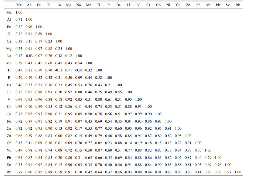
Major and trace element contents in surface sediments and materials transported from surrounding major rivers are shown in Table 1. In the surface sediments, the dominant element was Al (average=6.8%), followed by Fe (average=3.1%); Mn content exhibited the highest variation coefficient (20.1%), while Ti content had the lowest variation coefficient (5.0%). Among the trace elements, Ba had the highest concentration (average=457.0 μg/g), followed by Sr (average=194.4 μg/g); the variation coefficient of the Cu content was highest, reaching up to 18.9%, while the variation coefficient of the Ba content was lowest (5.9%). In general, the variation coefficients (C. V.) of elements were relatively low (C.V. < 21%), suggesting that the sediment composition at different stations was similar. The average content of each element fell within known ranges of four major rivers in China and Korea (Yang et al., 2003b, 2004b). The distribution of several selected element contents are displayed in Fig. 4. Major and trace element contents exhibited different distribution characteristics. The distribution of typical terrestrial elements, such as Al, Ti, and Sc, were similar, and all displayed high contents in nearshore areas and low values further offshore. Elements such as Ca and Sr that are strongly influenced by marine organisms were evenly distributed in the study area. There was only one zone in the southwestern region of the study area where the values of Ca and Sr were high, which may be due to the influence of nearshore shellfish culturing; here, the content of shells in the surface sediments was significantly higher than in other areas.

|

|
| Fig.4 The distribution of the typical elements of the surface sediments in the study area |
Figure 5 illustrates the distribution characteristics of surface and bottom water temperature and salinity in winter and summer. The summer surface water temperature varied between 20.4 ℃ and 28.8 ℃, and was characterized by lower temperatures nearshore and higher temperatures further offshore. The bottom water temperature varied between 14.2 ℃ and 21.0 ℃, and showed the opposite trend to surface waters with higher temperatures nearshore and lower temperatures offshore. Variations in temperatures of each water column layer were small in the shallow nearshore area, but there was a significant gradient further offshore. Overall, water temperatures were higher in upper layers and lower in deeper layers.

|
| Fig.5 The plane distribution of temperature and salinity of the surface and bottom water bodies in winter and summer |
In the study area, the distribution of thermohaline characteristics in winter surface and bottom waters was essentially consistent (Fig. 5). The temperature and salinity in coastal areas were globally lower than on the outer shelf. For the inshore low temperature and salinity area, the temperature was 6.2–7.8 ℃ and the salinity was 31.1–31.5; similar values were found throughout the coastal area centered around 37.7°N in a "tongue" shape from west to east. For the offshore high temperature and salinity area, the temperature was 9.8–10 ℃ and the salinity was 31.9–32.1, distributed in the northern part of the study area nearly parallel to the coastline. Between these two water mass areas with different properties, the temperature and salinity changed in a stepwise manner, forming a shear front in the east-west direction.
4 DISCUSSION 4.1 Qualitative identification of sediment provenanceElemental content in marine sediments is easily influenced by the particle size effect (Kremling and Streu, 1993). To analyze the influence of particle size on elements in the surface sediments, the correlation coefficients between several representative elements and Mz were analyzed (Fig. 6). The results showed that the elements Al, K, Mg, Fe, and Sc had a strong correlation with Mz (0.5 < R2 < 0.55). Therefore, particle size had some effect on sedimentary element contents in the study area.

|
| Fig.6 Correlation between element content and Mz |
To further examine the controlling factors on element content, an R-type factor and correlation analysis were conducted for the major and trace elements in 62 surface sediment samples using the statistical software SPSS19.0. Common factors with eigenvalues >1 were extracted using the principal component method and a covariance matrix. The results showed that the Kaiser-Meyer-Olkin value was 0.89 and the P-value of Bartlett's spherical test was 0, which indicates that the analysis was suitable and exhibited a high level of confidence. This method extracted two common factors (1 and 2) accounting for 94.21% of the total variance, suggesting that the major and trace element contents were mainly controlled by these two factors (Table 2).

Factor 1 was responsible for 83.64% of the total variance, which is significantly higher than factor 2. Therefore, factor 1 has a decisive influence on the elemental composition of surface sediments in the study area. Most elements have a high loading in factor 1 and a high correlation with Al and other rockforming elements (correlation coefficient R was generally >0.8). The high loading of the stable rockforming elements (e.g., Al, Fe, Mg, and Ti) and typical terrestrial elements (e.g., V, Cr, and Sc) in factor 1 indicates that terrestrial input is the main controlling factor of the element content. Factor 2 is responsible for 10.57% of the total variance and Ca, Na, and Sr have a higher loading in factor 2. Ca and Sr are two typical biological carbonate elements. Ca content (2.21%–3.5%) varied widely in surface sediments, and was substantially higher than in terrestrial matter from Korean rivers with some stations showing even higher values than input from the Changjiang River. The weak correlation between Ca and most of the rock-forming elements (e.g., Al and Ti) (Table 3) indicates that sedimentary Ca and Sr were affected by marine organisms. Na is an extremely mobile element, which is often transferred between seawater and sediments in adsorbed and free states (Li et al., 2017). Its correlation with terrestrial elements (e.g., Al and Ti) is noticeably weak, indicating that Na in the surface sediments was greatly affected by adsorption and eluviation during material transport. Therefore, factor 2 represents the marine biological carbonate component. Overall, terrestrial material input is the main controlling factor for the elemental composition of surface sediments.
The input of terrigenous material to the NYS mainly includes river-derived sediment, marine sediment transported from other areas and coastal erosion (Cheng, 2000). River-derived sediment is mainly distributed around the eastern Liaoning and northern Shandong peninsulas. According to Qin et al. (1989), the amount of Yalu River-derived sediment into the NYS is about 0.56×10⁶ t/a, accounting for about 60% of the total sediment transported into the NYS from the eastern Liaoning Peninsula. According to the Chinese Harbors and Embayments (volume 3; State Oceanic Administration, 1991), river-derived sediment from the northern Shandong Peninsula is about 1.4×10⁶ t/a (without considering river filtration efficiency). At present, most rivers are dammed and have reservoirs, which reduce the amount of sediment entering the NYS (Cheng, 2000). Therefore, sediment transported into the NYS is mainly from the Yalu River. Sediments from other marine areas are mainly from the Bohai and South Yellow Seas. The Huanghe River is the main sediment source into the Bohai Sea (Cheng, 2000) with a drainage area of 0.75×10⁶ km2 and annual sediment transport of 11×108 t (Milliman and Meade, 1983; Hay, 1998). According to Qin and Li (1986) and Martin et al. (1993), there is about (5– 10)×106 t/a of Huanghe River sediments entering the NYS through the Bohai Strait. Material in the South Yellow Sea mainly originates from the Changjiang, Huanghe, and Korean rivers (Yang and Youn, 2007). The Changjiang River flows into the East China Sea from a drainage area of about 1.8×10⁶ km2 and with a sediment discharge of 5×10⁸ t/a(Milliman and Meade, 1983; Hay, 1998). The Keum and Yeongsan rivers are representative Korean rivers flowing into the South Yellow Sea with drainage areas of 9.9×10³ km2 and 2.8×10³ km2, respectively. The sediment transport capacity of the Keum River is 5.6×10⁶ t/a, while the Yeongsan River is less than 1×10⁶ t/a (Schubel et al., 1984; Cho, 1994). Gao et al. (1996) estimated that sediment carried by the YSWC is about 3×10⁶ t/a and could be 1×10⁶t/a when it reaches the NYS. Therefore, material from other marine areas is mainly composed of sediments from the Huanghe, Changjiang, and Korean rivers. The study area is located near the coast of the Shandong Peninsula, which is dominated by bedrock. Under the influence of waves, the coast experiences a certain amount of erosion, but this quantity is relatively small compared with riverderived sediment (Cheng, 2000; Bi et al., 2011). In summary, terrigenous input to the NYS mainly includes sediments from the Yalu, Changjiang, Huanghe and Korean rivers.
The Korean (Keum and Yeongsan) river basins are mainly composed of Jurassic and Cretaceous granites, Precambrian gneiss, and Quaternary loose alluvial deposits; this differs from the Changjiang River Basin where Paleozoic carbonate rocks and transition metal deposits are widely distributed (Milliman and Meade, 1983). The Huanghe River sediments mainly exhibit loess characteristics (Yang and Li, 1999a). Archean metamorphic rocks and granite are widely distributed in the Yalu River Basin, whose element composition is similar to China-Korea quasi-platform granite and Korean Peninsula granite (State Oceanic Administration, 1998). Consequently, Huanghe River sediments are characterized by high contents of Ca and Sr (Yang and Li, 1999a, b), Changjiang River sediments are characterized by a relatively high content of trace elements (e.g., Co, V, and Cr) (Yang and Li, 1999b; Yang et al., 2003b), Yalu River sediments are characterized by high K content (Li et al., 2010), and the Korean river sediments are characterized by high Al, K, and Ba (Zhao et al., 1990; Cho et al., 1999; Kim et al., 1999).
Compared with individual element values, element ratios can better reflect characteristics in source regions (Yang et al., 2003a); elements normalized to Al are often used to distinguish the source of terrestrial material (Pattan et al., 2008; Tripathy et al., 2014; Li et al., 2017). Since the ratios of most elements to Al in the study area were weakly correlated with Mz, Sc was used instead of Al because it had a strong correlation with Al content and high loading in factor 1. Additionally, the use of normalization to Sc to identify sediment sources was better for eliminating the influence of particle size. According to the correlation graph of X/Sc and Mz (Fig. 7), ratios of selected elements were irrelevant to Mz, which indicated that the particle size effect was effectively eliminated. The contents of sedimentary Rb, Co, and Sc in the rivers of China and Korea were significantly different, and their loading in factor 1 was very high. Therefore, a binary diagram of Rb/Sc to Co/Sc was used to determine sediment provenance. As shown in Fig. 8, the drop point of sedimentary element ratios in the study area is closest to the Huanghe River, followed by the Changjiang and Yeongsan rivers; the Keum and Yalu rivers were the farthest. The sediment transport volume of the Yeongsan River is very small (< 0.2% of the Changjiang River), so its impact on sediments in the study area was correspondingly small. Therefore, surface sediments in the study area were mainly affected by material input from the Huanghe and Changjiang rivers. Sediments from the Korean rivers and the Yalu River had almost no influence on the sediments.

|
| Fig.7 Correlation coefficient of the element ratio and Mz |

|
| Fig.8 The binary diagram of Rb/Sc-Co/Sc Data of Changjiang River, Huanghe River, Keum River, and Yeongsan River are from Yang et al. (2003b); data of Yalu River are from Chen et al. (2000), Yang et al.(2002, 2003a). |
Performing a quantitative analysis is important when investigating sediment sources and sinks (Gao, 2003). The relative sedimentary contributions of two rivers (Huanghe and Changjiang rivers) to the study area were calculated to understand their influence on surface sediments. According to the law of conservation of matter, the mixture of sediments in these two regions (Huanghe and Changjiang rivers) must satisfy the following equation:

where X represents a sedimentary elemental ratio, Xi is the corresponding elemental ratio in a source i and fi represents the contribution of source i. Considering that 0 ≤fi≤1, the supply of material from three sources to the surface sediments of the study area was calculated by the least-squares method (Watson et al., 1990).
It is necessary for a quantitative estimation of sediment provenance to eliminate the factors first that influence sediment composition, such as marine biological actions, chemical actions, and effects from particle size during sedimentation. Therefore, the elements V, Cr, Co, Pb, Rb, and Sc were used because they exhibited a high loading in factor 1 and significant differences in sedimentary content of various rivers; their ratios to Al also exhibited poor correlation with Mz and were not affected by particle size (Fig. 7). Five ratios (V/Sc, Cr/Sc, Co/Sc, Pb/Sc, and Rb/Sc) were used to quantitatively examine the contribution of sediments from the Huanghe and Changjiang rivers to the surface sediments of the study area.
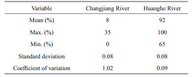
The results showed that the Huanghe River was the main source of surface sediments in the study area. The average relative contribution of the Huanghe River (92%) was significantly higher than the Changjiang River (8%) (Table 4) and had a relatively uniform contribution to each station in the study area (Fig. 9). The overall performance showed that contributions from both the Huanghe and Changjiang rivers were messy with no obvious pattern.
|

|
| Fig.9 The contribution plane distribution of the Huanghe River and the Changjiang River to the surface sediments in the study area |
Circulation in the NYS shows significant seasonal differences. In winter, NYS water masses are wellmixed vertically due to strong winds and waves. The current field of the NYS is the same at the bottom and the surface, with a cyclonic counterclockwise circulation (Miao et al., 1990, 1991; Lu et al., 2011). In summer, the overall circulation characteristics are not obvious and the upper and deeper water masses also display clear differences. The upper waters continue to exhibit a counterclockwise cyclonic circulation, but the effect is noticeably weaker than in winter. The deeper waters are mainly covered by cold water masses (Guan, 1963; Liu et al., 2004; Qiao et al., 2017), and only the SLCC carries Yalu River sediment into the NYS (Beardsley et al., 1985; Li et al., 2014; Wang et al., 2019).
In summer, the overall salinity (~32) in the study area was significantly higher than that in winter (Fig. 5), suggesting that the YSWC and NSCC weakened or even disappeared (Riedlinger and Jacobs, 2000; Bao et al., 2009). Sediments from the Huanghe, Changjiang, and Korean rivers were thus difficult to transport into the NYS without these currents. Only sediments from the Yalu River could be deposited in the NYS (Fig. 10). However, under the cold water masses in the NYS, material from the Yalu River was difficult to transport to the northeastern area off Shandong Peninsula, so it was mainly transported to the northern and western NYS by the SLCC. In winter, the YSWC and NSCC were obviously developed (Fig. 5). The high temperature and salinity YSWC and low temperature and salinity NSCC meet in a confluence area at about 37.7°N, which is consistent with previous studies showing that the YSWC moves westward around 123°E after entering the NYS (Zhang, 2018). Although Yalu River-derived sediment could reach the western NYS by cross-front sediment transport under winter winds (Shi et al., 2019), a limited amount of these sediments can diffused to the northeast of Shandong Peninsula in the distance under the influence of the east-west temperature and salinity fronts. Only the sediments carried by the YSWC and NSCC passed through the study area directly and were deposited (Fig. 10). In conclusion, the sediments in the study area were mainly carried by the YSWC and the NSCC in winter, as consistent with the results shown by the binary diagram of Co/Sc to Rb/Sc.

|
| Fig.10 Conceptual diagram of sediment transport model in summer and winter |
Sediments from the Changjiang River and Korean rivers were mainly carried into the NYS by the YSWC (Yang et al., 2004a; Lim et al., 2014). Although the Changjiang River flows into the East China Sea, its sediment transport capacity can reach 5×10⁸ t/a; in contrast, the transport capacity of the Korean rivers is less than 1% of the Changjiang River. Therefore, Korean river sediments carried by the YSWC can be ignored, as they are negligible compared with the Changjiang River. There were two main sedimentation modes for Huanghe River sediments into the study area: (1) they were mainly carried by the SBCC across the Bohai Strait in winter and continued eastward via the NSCC, with some sediment directly deposited in the study area; (2) they were initially carried by the SSCC into the South Yellow Sea and subsequently carried back to the NYS by the YSWC before deposition in the study area (Yang et al., 2003a, b). Huanghe River material carried by the NSCC was about (5–10)×106 t/a, much higher than material carried into the NYS by the YSWC. This difference means that the Huanghe River acts as the main sedimentary source in the study area with an average relative contribution of 92%.
The study area is a regular semidiurnal tidal sea and the M2 tidal constituent is the main component (Bian, 2012) with a velocity of 50–70 cm/s (Zhu et al., 2012). This is sufficient to achieve the dynamic conditions of sediment resuspension. Additionally, the wave base in waters near Weihai Bay can exceed 30 m in summer and winter (Zhong et al., 2020). As the water depth in this region of the study area is shallow (~22–30 m), the effect of waves and currents on sediment redistribution should not be ignored. Sediments from the Changjiang and Huanghe rivers repeatedly undergo cycles of resuspension-transportdeposition because of the joint action of tidal currents and waves, which produces a random mixing of sediments from these two major sources. Under the secondary transformation of waves and tides, Changjiang River material entering the study area from the north could be transported to the south along the coast, whereas Huanghe River material entering the nearshore study area could be transported further offshore. This activity could have disrupted the distribution of sediments with different relative contributions from the Huanghe and Changjiang rivers.
In summary, Huanghe River material carried by the NSCC in winter was the main source of sediments in the study area, and Changjiang River material carried by the YSWC also had a certain contribution. Tidal currents and waves mainly affected the secondary distribution of material from these two riverine sources.
5 CONCLUSION(1) The study area mainly contained two types of sediments: sandy silt and silt. Surface sediment Mz varied between 4.94Φ and 6.33Φ. Among the major elements, Al content was highest, followed by Fe. For trace elements, the content of Ba was highest, followed by Sr.
(2) The elemental content of the surface sediments was mainly controlled by the input of terrestrial material. Based on a binary diagram of Rb/Sc to Co/Sc, the Huanghe River was identified as the main source of surface sediments, but Changjiang River sediments also had a certain contribution.
(3) The results show that the contribution of Huanghe River sediment to the study area was up to 92%, while that of the Changjiang River was ~8%.
(4) The YSWC and the NSCC showed a confluence zone at 37.7°N in winter, and were the main transport forces for sediments from the two main river sources. However, there was a deficit of material transported into the study area in summer. The secondary distribution of river sediment from the two sources (Huanghe and Changjiang rivers) was controlled by tidal currents and waves.
6 DATA AVAILABILITY STATEMENTThe datasets generated during and/or analyzed during the current study are available from the corresponding author on reasonable request.
7 ACKNOWLEDGMENTThe authors would like to thank MA Li, QI Luyang, XIE Hang, and LIU Tao from the Ocean University of China for assistance with laboratory analyses.
Bao X W, Li N, Yao Z G, Wu D X. 2009. Seasonal variation characteristics of temperature and salinity of the North Yellow Sea. Periodical of Ocean University of China, 39(4): 553-562.
(in Chinese with English abstract) |
Beardsley R C, Limeburner R, Yu H, Cannon G A. 1985. Discharge of the Changjiang (Yangtze River) into the East China Sea. Continental Shelf Research, 4(1-2): 57-76.
DOI:10.1016/0278-4343(85)90022-6 |
Bi N H, Yang Z S, Wang H J, Fan D J, Sun X X, Lei K. 2011. Seasonal variation of suspended-sediment transport through the southern Bohai Strait. Estuarine, Coastal and Shelf Science, 93(3): 239-247.
DOI:10.1016/j.ecss.2011.03.007 |
Bian C W. 2012. Chinese coastal sediment transport in the Bohai Sea, Yellow Sea and East China Sea. PhD thesis. Ocean University of China, Qingdao. (in Chinese with English abstract)
|
Chen J S, Wang F Y, Li X D, Song J J. 2000. Geographical variations of trace elements in sediments of the major rivers in eastern China. Environmental Geology, 39(12): 1 334-1 340.
DOI:10.1007/s002540000224 |
Cheng P. 2000. Sediment characteristics and transport processes of fine-grained material over the Northern Yellow Sea. PhD thesis. The Institute of Oceanology, Chinese Academy of Sciences, Qingdao. (in Chinese with English abstract)
|
Cho Y G. 1994. Distribution and Origin of Metallic Elements in Marine Sediments Around Korean Peninsula. PhD thesis. Seoul National University, Seoul. p. 25-45.
|
Cho Y G, Lee C B, Choi M S. 1999. Geochemistry of surface sediments off the southern and western coasts of Korea. Marine Geology, 159(1-4): 111-129.
DOI:10.1016/S0025-3227(98)00194-7 |
Dou Y G, Li J, Yang S Y. 2012. Element compositions and provenance implication of surface sediments in offshore areas of the eastern Shandong Peninsula in China. Acta Oceanologica Sinica, 34(1): 109-119.
(in Chinese with English abstract) |
Fang H C, Huang P, Zhou Y, Zhang J, Li A C, Yan J S. 2015. Distribution and controlling factors of the major elements in surface sediments of the North Yellow Sea. Marine Sciences, 39(4): 108-116.
(in Chinese with English abstract) |
Folk R L, Ward A W C. 1957. Brazos River bar[Texas]; A study in the significance of grain size parameters. Journal of Sedimentary Research, 27(1): 3-26.
DOI:10.1306/74D70646-2B21-11D7-8648000102C1865D |
Gao S, Park Y A, Zhao Y Y, Qin Y S, Lee C B. 1996. Transport and resuspension of fine-grained sediments over the Southeastern Yellow Sea. In: Proceedings of the Korea-China International Seminar on Holocene and Late Pleistocene Environments in the Yellow Sea Basin. Seoul National University Press, Seoul. p. 83-98.
|
Gao S. 2003. Tracer methods in marine sediment dynamics. Acta Sedimentologica Sinica, 21(1): 61-65.
(in Chinese with English abstract) |
Guan B X. 1963. A preliminary study of the temperature variations and the characteristics of the circulation of the cold water mass of the Yellow Sea. Oceanologia et Limnologia Sinica, 5(4): 255-284.
(in Chinese with English abstract) |
Hay W W. 1998. Detrital sediment fluxes from continents to oceans. Chemical Geology, 145(3-4): 287-323.
DOI:10.1016/S0009-2541(97)00149-6 |
Kim G, Yang H S, Church T M. 1999. Geochemistry of alkaline earth elements (Mg, Ca, Sr, Ba) in the surface sediments of the Yellow Sea. Chemical Geology, 153(1-4): 1-10.
DOI:10.1016/S0009-2541(98)00149-1 |
Kremling K, Streu P. 1993. Saharan dust influenced trace element fluxes in deep North Atlantic subtropical waters. Deep Sea Research Part I: Oceanographic Research Papers, 40(6): 1 155-1 168.
DOI:10.1016/0967-0637(93)90131-L |
Lan X H, Chen X H, Mi B B, Li R H, Qin Y C, Wang Z B. 2015a. Distribution pattern and source of major and trace elements in the central North Yellow Sea since late Pleistocene. Marine Geology & Quaternary Geology, 35(4): 1-10.
(in Chinese with English abstract) |
Lan X H, Mi B B, Chen X H, Li R H, Wang Z B, Lu K. 2015b. Tracing of rare earth elements in late quaternary sediments from central North Yellow Sea. Journal of the Chinese Society of Rare Earths, 33(2): 241-252.
(in Chinese with English abstract) |
Li G G, Hu B Q, Li J, Bu R Y, Yang M, Dou Y G. 2012. Geochemistry of major elements in the surface sediments of the offshore area of Shandong Peninsula and its geological implication. Marine Geology & Quaternary Geology, 32(3): 45-54.
(in Chinese with English abstract) |
Li G X, Yue S H, Zhao D B, Sun Y T. 2004. Rapid deposition and dynamic processes in the modern Yellow River Mouth. Marine Geology & Quaternary Geology, 24(3): 29-36.
(in Chinese with English abstract) |
Li J R, Liu S F, Feng X L, Sun X Q, Shi X F. 2017. Major and trace element geochemistry of the mid-Bay of Bengal surface sediments: implications for provenance. Acta Oceanologica Sinica, 36(3): 82-90.
DOI:10.1007/s13131-017-1041-z |
Li J S, Gao J H, Li J, Wang Z Y, Yan J, Bai F L, Cheng Y. 2010. Distribution and controlling factors of major elements in sediments of the Yalu River estuary. Marine Geology & Quaternary Geology, 30(1): 25-31.
(in Chinese with English abstract) |
Li Y, Li A C, Huang P, Xu F J, Zheng X F. 2014. Clay minerals in surface sediment of the north Yellow Sea and their implication to provenance and transportation. Continental Shelf Research, 90: 33-40.
DOI:10.1016/j.csr.2014.01.020 |
Lim D, Jung H S, Choi J Y. 2014. REE partitioning in riverine sediments around the Yellow Sea and its importance in shelf sediment provenance. Marine Geology, 357: 12-24.
DOI:10.1016/j.margeo.2014.07.002 |
Liu J, Saito Y, Kong X H, Wang H, Zhao L. 2009. Geochemical characteristics of sediment as indicators of post-glacial environmental changes off the Shandong Peninsula in the Yellow Sea. Continental Shelf Research, 29(7): 846-855.
DOI:10.1016/j.csr.2009.01.002 |
Liu J P, Milliman J D, Gao S, Cheng P. 2004. Holocene development of the Yellow River-s subaqueous delta, North Yellow Sea. Marine Geology, 209(1-4): 45-67.
DOI:10.1016/j.margeo.2004.06.009 |
Lu J, Qiao F L, Wang X H, Wang Y G, Teng Y, Xia C S. 2011. A numerical study of transport dynamics and seasonal variability of the Yellow River sediment in the Bohai and Yellow seas. Estuarine, Coastal and Shelf Science, 95(1): 39-51.
DOI:10.1016/j.ecss.2011.08.001 |
Lü X X, Song J M, Li X G, Yuan H M, Zhan T R, Li N, Gao X L. 2005. Geochemical characteristics and early diagenesis of nitrogen in the northern Yellow Sea Sediments. Acta Geologica Sinica, 79(1): 114-123.
(in Chinese with English abstract) |
Martin J M, Zhang J, Shi M C, Zhou Q. 1993. Actual flux of the Huanghe (Yellow River) sediment to the Western Pacific Ocean. Netherlands Journal of Sea Research, 31(3): 243-254.
DOI:10.1016/0077-7579(93)90025-N |
McManus J, Berelson W M, Klinkhammer G P, Johnson K S, Coale K H, Anderson R F, Kumar N, Burdige D J, Hammond D E, Brumsack H J, McCorkle D C, Rushdi A. 1999. Geochemistry of barium in marine sediments: implications for its use as a paleoproxy. Geochimica et Cosmochimica Acta, 62(21-22): 3 453-3 473.
|
Milliman J D, Meade R H. 1983. World-wide delivery of river sediment to the oceans. The Journal of Geology, 91(1): 1-21.
DOI:10.1086/628741 |
Miao J B, Liu X Q, Xue Y. 1990. A preliminary study on the formation mechanism of the North Yellow Sea cold water mass I. Model solution. Chinese Science (Part B Chemical Life Science Geosciences), (12): 1 311-1 321.
(in Chinese) |
Miao J B, Liu X Q, Xue Y. 1991. A preliminary study of the formation mechanism of the north Yellow Sea cold water mass -II. Discussion of the model solution. Chinese Science (Series B Chemical Life Sciences Geosciences), (1): 74-81.
(in Chinese) |
Pattan J N, Parthiban G, PrakashBabu C, Khadge N H, Paropkari A L, Kodagali V N. 2008. A note on geochemistry of surface sediments from Krishna-Godavari Basin, East Coast of India. Journal of the Geological Society of India, 71(1): 107-114.
|
Qi J, Li F Y, Song J M, Gao S, Wang G Z, Cheng P. 2004. Sedimentation rate and flux of the North Yellow Sea. Marine Geology & Quaternary Geology, 24(2): 9-14.
(in Chinese with English abstract) |
Qiao S Q, Shi X F, Wang G Q, Zhou L, Hu B Q, Hu L M, Yang G, Liu Y G, Yao Z Q, Liu S F. 2017. Sediment accumulation and budget in the Bohai Sea, Yellow Sea and East China Sea. Marine Geology, 390: 270-281.
DOI:10.1016/j.margeo.2017.06.004 |
Qin Y S, Li F. 1986. The influence of the sediment from the Yellow River into the Bohai Sea and the Yellow Sea. Studia Marina Sinica, 27: 125-135.
(in Chinese) |
Qin Y S, Zhao Y Y, Chen L R, Chen S L. 1989. Yellow Sea Geology. Science Press, Beijing. p.1-289.
(in Chinese)
|
Riedlinger S K, Jacobs G A. 2000. Study of the dynamics of wind-driven transports into the Yellow Sea during winter. Journal of Geophysical Research: Oceans, 105(C12): 28 695-28 708.
DOI:10.1029/2000JC900127 |
Schubel J R, Shen H T, Park M J. 1984. A comparison of some characteristic sedimentation processes of estuaries entering the Yellow Sea. In: Park Y A, Pilkey O H, Kim S W eds. Marine Geology and Physical Processes of the Yellow Sea. Korea Institute of Energy Resources, Seoul. p. 286-308.
|
Shi Y, Gao J H, Sheng H, Du J, Jia J J, Wang Y P, Li J, Bai F L, Chen Y N. 2019. Cross-front sediment transport induced by quick oscillation of the Yellow Sea Warm Current: evidence from the sedimentary record. Geophysical Research Letters, 46(1): 226-234.
DOI:10.1029/2018GL080751 |
State Oceanic Administration. 1991. Chinese Harbours and Embayments (Part 3)-Northernand Eastern Shandong Peninsula. China Ocean Press, Beijing. p.1-488.
(in Chinese)
|
State Oceanic Administration. 1998. Chinese Harbours and Embayments (Volume 14): Important Estuaries. China Ocean Press, Beijing. p. 386-432. (in Chinese)
|
Su J L. 2001. A review of circulation dynamics of the coastal oceans near China. Acta Oceanologica Sinica, 23(4): 1-16.
(in Chinese with English abstract) |
Teague W J, Jacobs G A. 2000. Current observations on the development of the Yellow Sea Warm Current. Journal of Geophysical Research: Oceans, 105(C2): 3 401-3 411.
DOI:10.1029/1999JC900301 |
Tripathy G R, Singh S K, Ramaswamy V. 2014. Major and trace element geochemistry of Bay of Bengal sediments: implications to provenances and their controlling factors. Palaeogeography, Palaeoclimatology, Palaeoecology, 397: 20-30.
DOI:10.1016/j.palaeo.2013.04.012 |
Wang A M, Ralston D K, Bi N S, Cheng Z, Wu X, Wang H J. 2019. Seasonal variation in sediment transport and deposition on a muddy clinoform in the Yellow Sea. Continental Shelf Research, 179: 37-51.
DOI:10.1016/j.csr.2019.04.009 |
Watson J G, Robinson N F, Chow J C, Henry R C, Kim B M, Pace T G, Meyer E L, Nguyen Q. 1990. The USEPA/DRI chemical mass balance receptor model, CMB 7.0. Environmental Software, 5(1): 38-49.
DOI:10.1016/0266-9838(90)90015-X |
Xu L L, Wu D X, Lin X P, Ma C. 2009. The study of the Yellow Sea warm current and its seasonal variability. Journal of Hydrodynamics, Ser. B, 21(2): 159-165.
DOI:10.1016/S1001-6058(08)60133-X |
Yang S Y, Jung H, Li C X, Lim D I. 2004b. Major element geochemistry of sediments from Chinese and Korean Rivers. Geochimica, 33(1): 99-105.
(in Chinese with English abstract) |
Yang S Y, Jung H S, Lim D I, Li C X. 2003a. A review on the provenance discrimination of sediments in the Yellow Sea. Earth-Science Reviews, 63(1-2): 93-120.
DOI:10.1016/S0012-8252(03)00033-3 |
Yang S Y, Li C X. 1999a. Characteristic element compositions of the Yangtze and the Yellow River sediments and their geological background. Marine Geology & Quaternary Geology, 19(2): 19-26.
|
Yang S Y, Li C X. 1999b. Element composition and tracing in modern surface sediments of the Yangtze and Yellow Rivers. Progress in Natural Science, 9(10): 9 30-9 37.
(in Chinese) |
Yang S Y, Li C X, Jung H S, Lee H J. 2002. Discrimination of geochemical compositions between the Changjiang and the Huanghe sediments and its application for the identification of sediment source in the Jiangsu coastal plain, China. Marine Geology, 186(3-4): 229-241.
DOI:10.1016/S0025-3227(02)00335-3 |
Yang S Y, Li C X, Jung H, Lim D I, Choi M S. 2003b. Geochemistry of trace elements in Chinese and Korean River sediments. Marine Geology & Quaternary Geology, 23(2): 19-24.
(in Chinese with English abstract) |
Yang S Y, Lim D I, Jung H S, Oh B C. 2004a. Geochemical composition and provenance discrimination of coastal sediments around Cheju Island in the southeastern Yellow Sea. Marine Geology, 206(1-4): 41-53.
DOI:10.1016/j.margeo.2004.01.005 |
Yang S Y, Youn J S. 2007. Geochemical compositions and provenance discrimination of the central south Yellow Sea sediments. Marine Geology, 243(1-4): 229-241.
DOI:10.1016/j.margeo.2007.05.001 |
Yang Z S, Dai H M, Wang K R. 2005. Daily variations of water discharge and sediment discharge into the sea from Yellow River from 1950 to 2000 and relevant influential factors that generate these changes. Periodical of Ocean University of China, 35(2): 237-244.
(in Chinese with English abstract) |
Yang Z S, Liu J P. 2007. A unique Yellow River-derived distal subaqueous delta in the Yellow Sea. Marine Geology, 240(1-4): 169-176.
DOI:10.1016/j.margeo.2007.02.008 |
Yu F, Zhang Z X, Diao X Y, Guo J S. 2010. Observational evidence of the Yellow Sea warm current. Chinese Journal of Oceanology and Limnology, 28(3): 677-683.
DOI:10.1007/s00343-010-0006-2 |
Zhang K N. 2018. The influence of the North Yellow Sea cold water mass on the properties of suspended particulate matter and sedimentary environment. University of Chinese Academy of Sciences (The Institute of Oceanology, Chinese Academy of Sciences), Qingdao. (in Chinese with English abstract)
|
Zhang S W, Wang Q Y, Lü Y, Cui H, Yuan Y L. 2008. Observation of the seasonal evolution of the Yellow Sea Cold Water Mass in 1996-1998. Continental Shelf Research, 28(3): 442-457.
DOI:10.1016/j.csr.2007.10.002 |
Zhao Y Y, Qin Z Y, Li F Y, Chen Y W. 1990. On the source and genesis of the mud in the central area of the South Yellow Sea. Chinese Journal of Oceanology and Limnology, 8(1): 66-73.
DOI:10.1007/BF02846453 |
Zhong W, Zhu L H, Dong P, Hu R J, Wu J Z, Zhu Y T, Duan H Q. 2020. Mechanisms of sediment trapping in coastal embayments off the Shandong Peninsula in summer-A case study in Weihai Bay. Estuarine, Coastal and Shelf Science, 236: 106623.
DOI:10.1016/j.ecss.2020.106623 |
Zhu X M, Bao X W, Song D H, Qiao L L, Huang B G, Shi X G. 2012. Numerical study on the tides and tidal currents in Bohai Sea, Yellow Sea and East China Sea. Oceanologia et Limnologia Sinica, 43(6): 1 103-1 113.
(in Chinese with English abstract) |